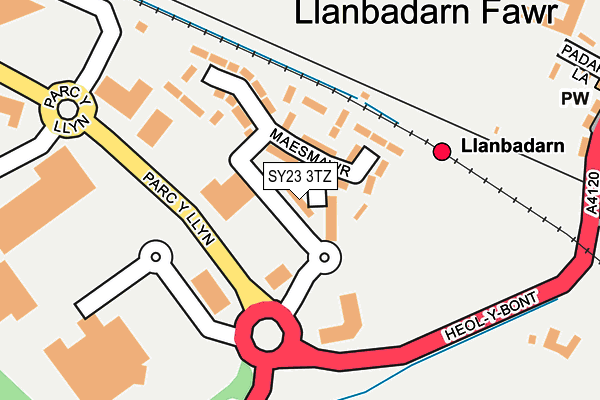
SY23 3TZ lies on Clos Ceitho in Llanbadarn Fawr, Aberystwyth. SY23 3TZ is located in the Llanbadarn Fawr electoral ward, within the unitary authority of Ceredigion and the Welsh Parliamentary constituency of Ceredigion. The Local Health Board is Hywel Dda University and the police force is Dyfed-Powys. This postcode has been in use since June 2000.


GetTheData
Source: OS OpenMap – Local (Ordnance Survey)
Source: OS VectorMap District (Ordnance Survey)
Licence: Open Government Licence (requires attribution)
| Easting | 259604 |
| Northing | 280674 |
| Latitude | 52.406009 |
| Longitude | -4.065284 |
GetTheData
Source: Open Postcode Geo
Licence: Open Government Licence
| Street | Clos Ceitho |
| Locality | Llanbadarn Fawr |
| Town/City | Aberystwyth |
| Country | Wales |
| Postcode District | SY23 |
➜ See where SY23 is on a map ➜ Where is Llanbadarn Fawr? | |
GetTheData
Source: Land Registry Price Paid Data
Licence: Open Government Licence
Elevation or altitude of SY23 3TZ as distance above sea level:
| Metres | Feet | |
|---|---|---|
| Elevation | 10m | 33ft |
Elevation is measured from the approximate centre of the postcode, to the nearest point on an OS contour line from OS Terrain 50, which has contour spacing of ten vertical metres.
➜ How high above sea level am I? Find the elevation of your current position using your device's GPS.
GetTheData
Source: Open Postcode Elevation
Licence: Open Government Licence
| Ward | Llanbadarn Fawr |
| Constituency | Ceredigion |
GetTheData
Source: ONS Postcode Database
Licence: Open Government Licence
| Maes Mawr | Aberystwyth | 66m |
| Morrisons (Morrisons Car Park) | Aberystwyth | 161m |
| Morrisons (Car Park) | Aberystwyth | 249m |
| Morrisons (Car Park) | Aberystwyth | 260m |
| Glynpadarn (Ffordd Sulien) | Llanbadarn Fawr | 346m |
| Llanbadarn (Vale Of Rheidol Railway) | Llanbadarn Fawr | 224m |
| Aberystwyth Station | 1.4km |
GetTheData
Source: NaPTAN
Licence: Open Government Licence
| Percentage of properties with Next Generation Access | 100.0% |
| Percentage of properties with Superfast Broadband | 100.0% |
| Percentage of properties with Ultrafast Broadband | 0.0% |
| Percentage of properties with Full Fibre Broadband | 0.0% |
Superfast Broadband is between 30Mbps and 300Mbps
Ultrafast Broadband is > 300Mbps
| Median download speed | 49.0Mbps |
| Average download speed | 41.5Mbps |
| Maximum download speed | 76.45Mbps |
| Median upload speed | 13.7Mbps |
| Average upload speed | 12.3Mbps |
| Maximum upload speed | 20.00Mbps |
| Percentage of properties unable to receive 2Mbps | 0.0% |
| Percentage of properties unable to receive 5Mbps | 0.0% |
| Percentage of properties unable to receive 10Mbps | 0.0% |
| Percentage of properties unable to receive 30Mbps | 0.0% |
GetTheData
Source: Ofcom
Licence: Ofcom Terms of Use (requires attribution)
Estimated total energy consumption in SY23 3TZ by fuel type, 2015.
| Consumption (kWh) | 140,173 |
|---|---|
| Meter count | 16 |
| Mean (kWh/meter) | 8,761 |
| Median (kWh/meter) | 8,843 |
| Consumption (kWh) | 32,199 |
|---|---|
| Meter count | 11 |
| Mean (kWh/meter) | 2,927 |
| Median (kWh/meter) | 2,620 |
GetTheData
Source: Postcode level gas estimates: 2015 (experimental)
Source: Postcode level electricity estimates: 2015 (experimental)
Licence: Open Government Licence
GetTheData
Source: ONS Postcode Database
Licence: Open Government Licence


➜ Get more ratings from the Food Standards Agency
GetTheData
Source: Food Standards Agency
Licence: FSA terms & conditions
| Last Collection | |||
|---|---|---|---|
| Location | Mon-Fri | Sat | Distance |
| Heol - Y - Llan | 16:45 | 11:45 | 461m |
| Penybont East | 16:45 | 11:45 | 534m |
| Minyddol | 17:00 | 11:45 | 563m |
GetTheData
Source: Dracos
Licence: Creative Commons Attribution-ShareAlike
The below table lists the International Territorial Level (ITL) codes (formerly Nomenclature of Territorial Units for Statistics (NUTS) codes) and Local Administrative Units (LAU) codes for SY23 3TZ:
| ITL 1 Code | Name |
|---|---|
| TLL | Wales |
| ITL 2 Code | Name |
| TLL1 | West Wales and The Valleys |
| ITL 3 Code | Name |
| TLL14 | South West Wales |
| LAU 1 Code | Name |
| W06000008 | Ceredigion |
GetTheData
Source: ONS Postcode Directory
Licence: Open Government Licence
The below table lists the Census Output Area (OA), Lower Layer Super Output Area (LSOA), and Middle Layer Super Output Area (MSOA) for SY23 3TZ:
| Code | Name | |
|---|---|---|
| OA | W00010060 | |
| LSOA | W01001935 | Ceredigion 003E |
| MSOA | W02000118 | Ceredigion 003 |
GetTheData
Source: ONS Postcode Directory
Licence: Open Government Licence
| SY23 3RW | Maesmawr | 96m |
| SY23 3TJ | Clos Non | 96m |
| SY23 3TQ | Clos Dewi | 97m |
| SY23 3TX | Clos Deiniol | 147m |
| SY23 3RB | Penybont Road | 337m |
| SY23 3QU | 342m | |
| SY23 3GJ | Clos Gwilym | 349m |
| SY23 3RQ | Lewis Terrace | 355m |
| SY23 3RG | Padarn Terrace | 357m |
| SY23 3GN | Clos Gwilym | 374m |
GetTheData
Source: Open Postcode Geo; Land Registry Price Paid Data
Licence: Open Government Licence