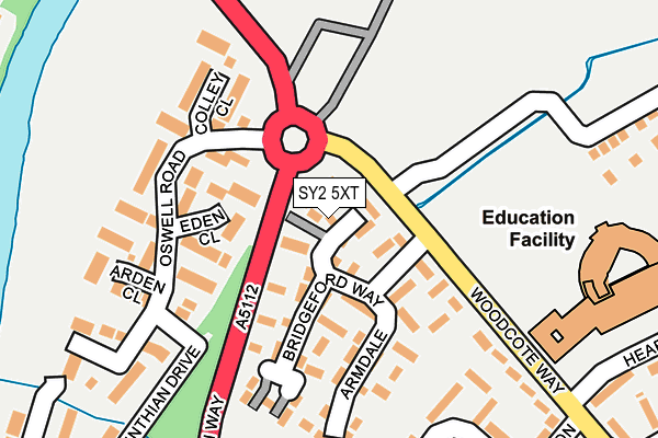
SY2 5XT lies on Lowfield in Shrewsbury. SY2 5XT is located in the Underdale electoral ward, within the unitary authority of Shropshire and the English Parliamentary constituency of Shrewsbury and Atcham. The Sub Integrated Care Board (ICB) Location is NHS Shropshire, Telford and Wrekin ICB - M2L0M and the police force is West Mercia. This postcode has been in use since January 1993.


GetTheData
Source: OS OpenMap – Local (Ordnance Survey)
Source: OS VectorMap District (Ordnance Survey)
Licence: Open Government Licence (requires attribution)
| Easting | 350797 |
| Northing | 313817 |
| Latitude | 52.719755 |
| Longitude | -2.729879 |
GetTheData
Source: Open Postcode Geo
Licence: Open Government Licence
| Street | Lowfield |
| Town/City | Shrewsbury |
| Country | England |
| Postcode District | SY2 |
➜ See where SY2 is on a map ➜ Where is Shrewsbury? | |
GetTheData
Source: Land Registry Price Paid Data
Licence: Open Government Licence
Elevation or altitude of SY2 5XT as distance above sea level:
| Metres | Feet | |
|---|---|---|
| Elevation | 50m | 164ft |
Elevation is measured from the approximate centre of the postcode, to the nearest point on an OS contour line from OS Terrain 50, which has contour spacing of ten vertical metres.
➜ How high above sea level am I? Find the elevation of your current position using your device's GPS.
GetTheData
Source: Open Postcode Elevation
Licence: Open Government Licence
| Ward | Underdale |
| Constituency | Shrewsbury And Atcham |
GetTheData
Source: ONS Postcode Database
Licence: Open Government Licence
| Bridgeford Way Jct (Telford Way) | Monkmoor | 103m |
| Hearne Way Jct (Telford Way) | Monkmoor | 231m |
| Aston Butts Jct (Judith Butts Gardens) | Monkmoor | 238m |
| Rushton Road Jct (Judith Butts Gardens) | Monkmoor | 281m |
| No. 4 (Rushton Road) | Monkmoor | 283m |
| Shrewsbury Station | 1.6km |
GetTheData
Source: NaPTAN
Licence: Open Government Licence
| Percentage of properties with Next Generation Access | 100.0% |
| Percentage of properties with Superfast Broadband | 100.0% |
| Percentage of properties with Ultrafast Broadband | 0.0% |
| Percentage of properties with Full Fibre Broadband | 0.0% |
Superfast Broadband is between 30Mbps and 300Mbps
Ultrafast Broadband is > 300Mbps
| Median download speed | 40.0Mbps |
| Average download speed | 34.8Mbps |
| Maximum download speed | 70.46Mbps |
| Median upload speed | 10.0Mbps |
| Average upload speed | 8.7Mbps |
| Maximum upload speed | 19.53Mbps |
| Percentage of properties unable to receive 2Mbps | 0.0% |
| Percentage of properties unable to receive 5Mbps | 0.0% |
| Percentage of properties unable to receive 10Mbps | 0.0% |
| Percentage of properties unable to receive 30Mbps | 0.0% |
GetTheData
Source: Ofcom
Licence: Ofcom Terms of Use (requires attribution)
Estimated total energy consumption in SY2 5XT by fuel type, 2015.
| Consumption (kWh) | 166,595 |
|---|---|
| Meter count | 21 |
| Mean (kWh/meter) | 7,933 |
| Median (kWh/meter) | 7,751 |
| Consumption (kWh) | 67,301 |
|---|---|
| Meter count | 21 |
| Mean (kWh/meter) | 3,205 |
| Median (kWh/meter) | 2,848 |
GetTheData
Source: Postcode level gas estimates: 2015 (experimental)
Source: Postcode level electricity estimates: 2015 (experimental)
Licence: Open Government Licence
GetTheData
Source: ONS Postcode Database
Licence: Open Government Licence


➜ Get more ratings from the Food Standards Agency
GetTheData
Source: Food Standards Agency
Licence: FSA terms & conditions
| Last Collection | |||
|---|---|---|---|
| Location | Mon-Fri | Sat | Distance |
| Armdale | 19:00 | 12:00 | 97m |
| Oswell Road | 19:00 | 12:00 | 113m |
| Monkmoor Road P.o. | 18:45 | 11:45 | 429m |
GetTheData
Source: Dracos
Licence: Creative Commons Attribution-ShareAlike
The below table lists the International Territorial Level (ITL) codes (formerly Nomenclature of Territorial Units for Statistics (NUTS) codes) and Local Administrative Units (LAU) codes for SY2 5XT:
| ITL 1 Code | Name |
|---|---|
| TLG | West Midlands (England) |
| ITL 2 Code | Name |
| TLG2 | Shropshire and Staffordshire |
| ITL 3 Code | Name |
| TLG22 | Shropshire |
| LAU 1 Code | Name |
| E06000051 | Shropshire |
GetTheData
Source: ONS Postcode Directory
Licence: Open Government Licence
The below table lists the Census Output Area (OA), Lower Layer Super Output Area (LSOA), and Middle Layer Super Output Area (MSOA) for SY2 5XT:
| Code | Name | |
|---|---|---|
| OA | E00147631 | |
| LSOA | E01028989 | Shropshire 018F |
| MSOA | E02006032 | Shropshire 018 |
GetTheData
Source: ONS Postcode Directory
Licence: Open Government Licence
| SY2 5YW | Eden Close | 88m |
| SY2 5XX | Bridgeford Way | 95m |
| SY2 5YL | Oswell Road | 169m |
| SY2 5YN | Colley Close | 176m |
| SY2 5YP | Arden Close | 204m |
| SY2 5SG | Woodcote Way | 223m |
| SY2 5SD | Judith Butts Gardens | 228m |
| SY2 5HW | Drake Close | 243m |
| SY2 5SF | Rushton Road | 278m |
| SY2 5SA | Aston Butts | 294m |
GetTheData
Source: Open Postcode Geo; Land Registry Price Paid Data
Licence: Open Government Licence