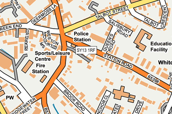
SY13 1RF is located in the Whitchurch South electoral ward, within the unitary authority of Shropshire and the English Parliamentary constituency of North Shropshire. The Sub Integrated Care Board (ICB) Location is NHS Shropshire, Telford and Wrekin ICB - M2L0M and the police force is West Mercia. This postcode has been in use since January 1980.


GetTheData
Source: OS OpenMap – Local (Ordnance Survey)
Source: OS VectorMap District (Ordnance Survey)
Licence: Open Government Licence (requires attribution)
| Easting | 354612 |
| Northing | 341438 |
| Latitude | 52.968368 |
| Longitude | -2.677257 |
GetTheData
Source: Open Postcode Geo
Licence: Open Government Licence
| Country | England |
| Postcode District | SY13 |
➜ See where SY13 is on a map ➜ Where is Whitchurch? | |
GetTheData
Source: Land Registry Price Paid Data
Licence: Open Government Licence
Elevation or altitude of SY13 1RF as distance above sea level:
| Metres | Feet | |
|---|---|---|
| Elevation | 100m | 328ft |
Elevation is measured from the approximate centre of the postcode, to the nearest point on an OS contour line from OS Terrain 50, which has contour spacing of ten vertical metres.
➜ How high above sea level am I? Find the elevation of your current position using your device's GPS.
GetTheData
Source: Open Postcode Elevation
Licence: Open Government Licence
| Ward | Whitchurch South |
| Constituency | North Shropshire |
GetTheData
Source: ONS Postcode Database
Licence: Open Government Licence
| Queens Road Jct (Station Road) | Whitchurch | 44m |
| Queens Road Jct (Station Road) | Whitchurch | 66m |
| Wayland Road Jct (Station Road) | Whitchurch | 302m |
| Smithfield Shopping Centre (Brownlow Street) | Whitchurch | 304m |
| Wayland Road Jct (Station Road) | Whitchurch | 313m |
| Whitchurch (Shrops) Station | 0.4km |
GetTheData
Source: NaPTAN
Licence: Open Government Licence
GetTheData
Source: ONS Postcode Database
Licence: Open Government Licence


➜ Get more ratings from the Food Standards Agency
GetTheData
Source: Food Standards Agency
Licence: FSA terms & conditions
| Last Collection | |||
|---|---|---|---|
| Location | Mon-Fri | Sat | Distance |
| Fountain | 17:30 | 11:30 | 184m |
| Station Road | 17:30 | 11:45 | 354m |
| Brownlow Road | 17:30 | 11:15 | 372m |
GetTheData
Source: Dracos
Licence: Creative Commons Attribution-ShareAlike
The below table lists the International Territorial Level (ITL) codes (formerly Nomenclature of Territorial Units for Statistics (NUTS) codes) and Local Administrative Units (LAU) codes for SY13 1RF:
| ITL 1 Code | Name |
|---|---|
| TLG | West Midlands (England) |
| ITL 2 Code | Name |
| TLG2 | Shropshire and Staffordshire |
| ITL 3 Code | Name |
| TLG22 | Shropshire |
| LAU 1 Code | Name |
| E06000051 | Shropshire |
GetTheData
Source: ONS Postcode Directory
Licence: Open Government Licence
The below table lists the Census Output Area (OA), Lower Layer Super Output Area (LSOA), and Middle Layer Super Output Area (MSOA) for SY13 1RF:
| Code | Name | |
|---|---|---|
| OA | E00147146 | |
| LSOA | E01028895 | Shropshire 001D |
| MSOA | E02006015 | Shropshire 001 |
GetTheData
Source: ONS Postcode Directory
Licence: Open Government Licence
| SY13 1RD | Station Road | 61m |
| SY13 1RE | Station Road | 72m |
| SY13 1QJ | Bridgewater Street | 99m |
| SY13 1PU | Talbot Street | 113m |
| SY13 1PT | Talbot Street | 126m |
| SY13 1TJ | Anchor Close | 130m |
| SY13 1RG | Queens Road | 130m |
| SY13 1UU | Weston Court Mews | 133m |
| SY13 1QF | Brook Road | 154m |
| SY13 1RQ | Salisbury Road | 176m |
GetTheData
Source: Open Postcode Geo; Land Registry Price Paid Data
Licence: Open Government Licence