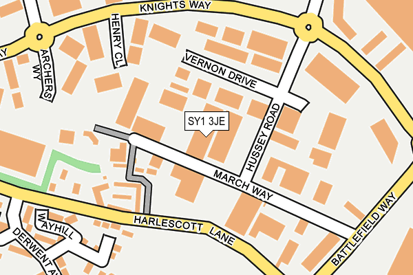
SY1 3JE lies on March Way in Battlefield Enterprise Park, Shrewsbury. SY1 3JE is located in the Harlescott electoral ward, within the unitary authority of Shropshire and the English Parliamentary constituency of Shrewsbury and Atcham. The Sub Integrated Care Board (ICB) Location is NHS Shropshire, Telford and Wrekin ICB - M2L0M and the police force is West Mercia. This postcode has been in use since January 1991.


GetTheData
Source: OS OpenMap – Local (Ordnance Survey)
Source: OS VectorMap District (Ordnance Survey)
Licence: Open Government Licence (requires attribution)
| Easting | 350288 |
| Northing | 316517 |
| Latitude | 52.743978 |
| Longitude | -2.737824 |
GetTheData
Source: Open Postcode Geo
Licence: Open Government Licence
| Street | March Way |
| Locality | Battlefield Enterprise Park |
| Town/City | Shrewsbury |
| Country | England |
| Postcode District | SY1 |
| ➜ SY1 open data dashboard ➜ See where SY1 is on a map ➜ Where is Shrewsbury? | |
GetTheData
Source: Land Registry Price Paid Data
Licence: Open Government Licence
Elevation or altitude of SY1 3JE as distance above sea level:
| Metres | Feet | |
|---|---|---|
| Elevation | 70m | 230ft |
Elevation is measured from the approximate centre of the postcode, to the nearest point on an OS contour line from OS Terrain 50, which has contour spacing of ten vertical metres.
➜ How high above sea level am I? Find the elevation of your current position using your device's GPS.
GetTheData
Source: Open Postcode Elevation
Licence: Open Government Licence
| Ward | Harlescott |
| Constituency | Shrewsbury And Atcham |
GetTheData
Source: ONS Postcode Database
Licence: Open Government Licence
| January 2024 | Violence and sexual offences | On or near Rutland | 382m |
| October 2023 | Anti-social behaviour | On or near Rutland | 382m |
| October 2023 | Anti-social behaviour | On or near Rutland | 382m |
| ➜ March Way crime map and outcomes | |||
GetTheData
Source: data.police.uk
Licence: Open Government Licence
| Hussey Road Jct (Knights Way) | Battlefield | 206m |
| Burnt Tree (Knights Way) | Battlefield | 271m |
| Ford Garage (Battlefield Way) | Battlefield | 273m |
| Little Harlescott Lane Jct (Derwent Avenue) | Little Harlescott | 292m |
| Little Harlescott Lane Jct (Derwent Avenue) | Little Harlescott | 299m |
| Shrewsbury Station | 3.7km |
GetTheData
Source: NaPTAN
Licence: Open Government Licence
Estimated total energy consumption in SY1 3JE by fuel type, 2015.
| Consumption (kWh) | 268,338 |
|---|---|
| Meter count | 14 |
| Mean (kWh/meter) | 19,167 |
| Median (kWh/meter) | 15,399 |
GetTheData
Source: Postcode level gas estimates: 2015 (experimental)
Source: Postcode level electricity estimates: 2015 (experimental)
Licence: Open Government Licence
GetTheData
Source: ONS Postcode Database
Licence: Open Government Licence


➜ Get more ratings from the Food Standards Agency
GetTheData
Source: Food Standards Agency
Licence: FSA terms & conditions
| Last Collection | |||
|---|---|---|---|
| Location | Mon-Fri | Sat | Distance |
| Battlefield Enterprise Park | 18:45 | 11:30 | 78m |
| Battlefield Enterprise Park | 18:45 | 79m | |
| Littleover Avenue | 19:15 | 12:00 | 411m |
GetTheData
Source: Dracos
Licence: Creative Commons Attribution-ShareAlike
| Facility | Distance |
|---|---|
| Waincott Recreation Ground Waincott, Shrewsbury Grass Pitches | 452m |
| Kynaston Road Recreation Ground Kynaston Road, Shrewsbury Grass Pitches | 602m |
| The Grange Primary School Bainbridge Green, Shrewsbury Grass Pitches, Sports Hall | 879m |
GetTheData
Source: Active Places
Licence: Open Government Licence
| School | Phase of Education | Distance |
|---|---|---|
| Harlescott House School Harlescott House Lane, Shrewsbury, Shropshire, SY1 3BA | Not applicable | 180m |
| Greenacres Primary School Rutland, Off York Road, Harlescott Grange, Shrewsbury, SY1 3QG | Primary | 328m |
| The Prepatoria School 7 Park Plaza, Battlefield Enterprise Park, Shrewsbury, Shropshire, SY1 3AF | Not applicable | 409m |
GetTheData
Source: Edubase
Licence: Open Government Licence
The below table lists the International Territorial Level (ITL) codes (formerly Nomenclature of Territorial Units for Statistics (NUTS) codes) and Local Administrative Units (LAU) codes for SY1 3JE:
| ITL 1 Code | Name |
|---|---|
| TLG | West Midlands (England) |
| ITL 2 Code | Name |
| TLG2 | Shropshire and Staffordshire |
| ITL 3 Code | Name |
| TLG22 | Shropshire |
| LAU 1 Code | Name |
| E06000051 | Shropshire |
GetTheData
Source: ONS Postcode Directory
Licence: Open Government Licence
The below table lists the Census Output Area (OA), Lower Layer Super Output Area (LSOA), and Middle Layer Super Output Area (MSOA) for SY1 3JE:
| Code | Name | |
|---|---|---|
| OA | E00147456 | |
| LSOA | E01028958 | Shropshire 015E |
| MSOA | E02006029 | Shropshire 015 |
GetTheData
Source: ONS Postcode Directory
Licence: Open Government Licence
| SY1 3TF | Vernon Drive | 65m |
| SY1 3BA | Harlescott Lane | 180m |
| SY1 3SP | Chatwood Court | 191m |
| SY1 3TJ | Henry Close | 198m |
| SY1 3RH | Willington Close | 251m |
| SY1 3RZ | Wayhill | 253m |
| SY1 3RY | Little Harlescott Lane | 256m |
| SY1 3RJ | Chevin Close | 285m |
| SY1 3RU | Derwent Avenue | 318m |
| SY1 3RG | Allestree Close | 340m |
GetTheData
Source: Open Postcode Geo; Land Registry Price Paid Data
Licence: Open Government Licence