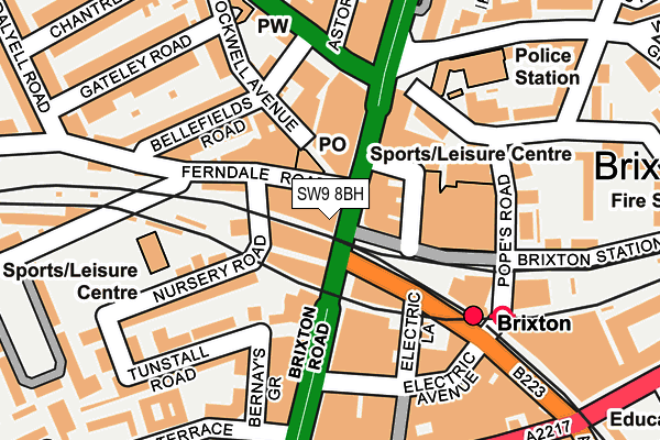
SW9 8BH is located in the Brixton North electoral ward, within the London borough of Lambeth and the English Parliamentary constituency of Vauxhall. The Sub Integrated Care Board (ICB) Location is NHS South East London ICB - 72Q and the police force is Metropolitan Police. This postcode has been in use since June 1999.


GetTheData
Source: OS OpenMap – Local (Ordnance Survey)
Source: OS VectorMap District (Ordnance Survey)
Licence: Open Government Licence (requires attribution)
| Easting | 531048 |
| Northing | 175543 |
| Latitude | 51.463696 |
| Longitude | -0.114890 |
GetTheData
Source: Open Postcode Geo
Licence: Open Government Licence
| Country | England |
| Postcode District | SW9 |
➜ See where SW9 is on a map ➜ Where is London? | |
GetTheData
Source: Land Registry Price Paid Data
Licence: Open Government Licence
Elevation or altitude of SW9 8BH as distance above sea level:
| Metres | Feet | |
|---|---|---|
| Elevation | 20m | 66ft |
Elevation is measured from the approximate centre of the postcode, to the nearest point on an OS contour line from OS Terrain 50, which has contour spacing of ten vertical metres.
➜ How high above sea level am I? Find the elevation of your current position using your device's GPS.
GetTheData
Source: Open Postcode Elevation
Licence: Open Government Licence
| Ward | Brixton North |
| Constituency | Vauxhall |
GetTheData
Source: ONS Postcode Database
Licence: Open Government Licence
| Brixton | Brixton | 81m |
| Brixton (Atlantic Road) | Brixton | 122m |
| Brixton (Brixton Road) | Brixton | 133m |
| Brixton Academy (Stockwell Road) | Brixton | 134m |
| Gresham Rd Brixton Police Stn (Gresham Road) | Brixton | 162m |
| Brixton Underground Station | Brixton | 120m |
| Clapham North Underground Station | Clapham | 1,061m |
| Stockwell Underground Station | Stockwell | 1,086m |
| Brixton Station | 0.1km |
| Loughborough Junction Station | 0.9km |
| Clapham High Street Station | 1.2km |
GetTheData
Source: NaPTAN
Licence: Open Government Licence
GetTheData
Source: ONS Postcode Database
Licence: Open Government Licence


➜ Get more ratings from the Food Standards Agency
GetTheData
Source: Food Standards Agency
Licence: FSA terms & conditions
| Last Collection | |||
|---|---|---|---|
| Location | Mon-Fri | Sat | Distance |
| 250 Ferndale Road | 17:30 | 12:00 | 52m |
| Electric Avenue | 17:30 | 12:00 | 159m |
| 10 Acre Lane | 17:30 | 12:00 | 325m |
GetTheData
Source: Dracos
Licence: Creative Commons Attribution-ShareAlike
The below table lists the International Territorial Level (ITL) codes (formerly Nomenclature of Territorial Units for Statistics (NUTS) codes) and Local Administrative Units (LAU) codes for SW9 8BH:
| ITL 1 Code | Name |
|---|---|
| TLI | London |
| ITL 2 Code | Name |
| TLI4 | Inner London - East |
| ITL 3 Code | Name |
| TLI45 | Lambeth |
| LAU 1 Code | Name |
| E09000022 | Lambeth |
GetTheData
Source: ONS Postcode Directory
Licence: Open Government Licence
The below table lists the Census Output Area (OA), Lower Layer Super Output Area (LSOA), and Middle Layer Super Output Area (MSOA) for SW9 8BH:
| Code | Name | |
|---|---|---|
| OA | E00015390 | |
| LSOA | E01003053 | Lambeth 015B |
| MSOA | E02000632 | Lambeth 015 |
GetTheData
Source: ONS Postcode Directory
Licence: Open Government Licence
| SW9 7DG | Brixton Road | 45m |
| SW9 8ED | Brixton Road | 46m |
| SW9 8PA | Brixton Station Road | 58m |
| SW9 8EA | Brixton Road | 88m |
| SW9 7DE | Brixton Road | 94m |
| SW9 8BN | Tunstall Road | 103m |
| SW9 8BP | Nursery Road | 109m |
| SW9 8BA | Ferndale Road | 110m |
| SW9 7QF | Canterbury Crescent | 119m |
| SW9 9UH | Bellefields Road | 121m |
GetTheData
Source: Open Postcode Geo; Land Registry Price Paid Data
Licence: Open Government Licence