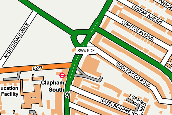
SW4 9DF is located in the Clapham Common & Abbeville electoral ward, within the London borough of Lambeth and the English Parliamentary constituency of Streatham. The Sub Integrated Care Board (ICB) Location is NHS South East London ICB - 72Q and the police force is Metropolitan Police. This postcode has been in use since April 2006.


GetTheData
Source: OS OpenMap – Local (Ordnance Survey)
Source: OS VectorMap District (Ordnance Survey)
Licence: Open Government Licence (requires attribution)
| Easting | 528865 |
| Northing | 174321 |
| Latitude | 51.453215 |
| Longitude | -0.146768 |
GetTheData
Source: Open Postcode Geo
Licence: Open Government Licence
| Country | England |
| Postcode District | SW4 |
➜ See where SW4 is on a map ➜ Where is London? | |
GetTheData
Source: Land Registry Price Paid Data
Licence: Open Government Licence
Elevation or altitude of SW4 9DF as distance above sea level:
| Metres | Feet | |
|---|---|---|
| Elevation | 30m | 98ft |
Elevation is measured from the approximate centre of the postcode, to the nearest point on an OS contour line from OS Terrain 50, which has contour spacing of ten vertical metres.
➜ How high above sea level am I? Find the elevation of your current position using your device's GPS.
GetTheData
Source: Open Postcode Elevation
Licence: Open Government Licence
| Ward | Clapham Common & Abbeville |
| Constituency | Streatham |
GetTheData
Source: ONS Postcode Database
Licence: Open Government Licence
| Clapham South (Balham Hill) | Clapham South | 103m |
| Cavendish Road Clapham South Station | Clapham Park | 107m |
| Cavendish Road Clapham South Station (Cavendish Road) | Clapham Park | 113m |
| Clapham South | Clapham South | 118m |
| Clapham South (Balham Hill) | Clapham South | 121m |
| Clapham South Underground Station | Clapham South | 84m |
| Clapham Common Underground Station | Clapham | 1,115m |
| Balham Underground Station | Balham | 1,186m |
| Clapham North Underground Station | Clapham | 1,764m |
| Balham Station | 1.2km |
| Wandsworth Common Station | 1.4km |
| Clapham High Street Station | 1.7km |
GetTheData
Source: NaPTAN
Licence: Open Government Licence
GetTheData
Source: ONS Postcode Database
Licence: Open Government Licence


➜ Get more ratings from the Food Standards Agency
GetTheData
Source: Food Standards Agency
Licence: FSA terms & conditions
| Last Collection | |||
|---|---|---|---|
| Location | Mon-Fri | Sat | Distance |
| 1 Westbury Parade | 17:30 | 12:00 | 110m |
| Nightingale Lane | 17:30 | 12:00 | 122m |
| 63 Balham Hill | 17:30 | 12:00 | 233m |
GetTheData
Source: Dracos
Licence: Creative Commons Attribution-ShareAlike
The below table lists the International Territorial Level (ITL) codes (formerly Nomenclature of Territorial Units for Statistics (NUTS) codes) and Local Administrative Units (LAU) codes for SW4 9DF:
| ITL 1 Code | Name |
|---|---|
| TLI | London |
| ITL 2 Code | Name |
| TLI4 | Inner London - East |
| ITL 3 Code | Name |
| TLI45 | Lambeth |
| LAU 1 Code | Name |
| E09000022 | Lambeth |
GetTheData
Source: ONS Postcode Directory
Licence: Open Government Licence
The below table lists the Census Output Area (OA), Lower Layer Super Output Area (LSOA), and Middle Layer Super Output Area (MSOA) for SW4 9DF:
| Code | Name | |
|---|---|---|
| OA | E00015257 | |
| LSOA | E01003030 | Lambeth 019D |
| MSOA | E02000636 | Lambeth 019 |
GetTheData
Source: ONS Postcode Directory
Licence: Open Government Licence
| SW4 9DX | Clapham Common South Side | 28m |
| SW4 9DP | Cavendish Parade | 29m |
| SW4 9DY | Maud Chadburn Place | 51m |
| SW4 9DW | Cavendish Parade | 68m |
| SW12 9PQ | Anchor Mews | 79m |
| SW12 9DY | Balham Hill | 90m |
| SW12 9PA | Englewood Road | 119m |
| SW12 9NZ | Englewood Road | 127m |
| SW4 9DN | Clapham Common South Side | 139m |
| SW12 9DX | Balham Hill | 147m |
GetTheData
Source: Open Postcode Geo; Land Registry Price Paid Data
Licence: Open Government Licence