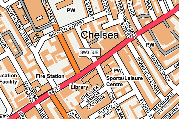
SW3 5UB is located in the Stanley electoral ward, within the London borough of Kensington and Chelsea and the English Parliamentary constituency of Chelsea and Fulham. The Sub Integrated Care Board (ICB) Location is NHS North West London ICB - W2U3Z and the police force is Metropolitan Police. This postcode has been in use since January 2019.


GetTheData
Source: OS OpenMap – Local (Ordnance Survey)
Source: OS VectorMap District (Ordnance Survey)
Licence: Open Government Licence (requires attribution)
| Easting | 527276 |
| Northing | 178155 |
| Latitude | 51.488030 |
| Longitude | -0.168220 |
GetTheData
Source: Open Postcode Geo
Licence: Open Government Licence
| Country | England |
| Postcode District | SW3 |
➜ See where SW3 is on a map ➜ Where is Chelsea? | |
GetTheData
Source: Land Registry Price Paid Data
Licence: Open Government Licence
Elevation or altitude of SW3 5UB as distance above sea level:
| Metres | Feet | |
|---|---|---|
| Elevation | 10m | 33ft |
Elevation is measured from the approximate centre of the postcode, to the nearest point on an OS contour line from OS Terrain 50, which has contour spacing of ten vertical metres.
➜ How high above sea level am I? Find the elevation of your current position using your device's GPS.
GetTheData
Source: Open Postcode Elevation
Licence: Open Government Licence
| Ward | Stanley |
| Constituency | Chelsea And Fulham |
GetTheData
Source: ONS Postcode Database
Licence: Open Government Licence
| Chelsea Old Town Hall | Chelsea | 44m |
| Chelsea Old Town Hall (King's Road) | Chelsea | 55m |
| Sydney Street Old Town Hall | Chelsea | 64m |
| Sydney Street Old Town Hall | Chelsea | 68m |
| Cale St Royal Brompton Hosp (Sydney Street) | Chelsea | 231m |
| South Kensington Underground Station | South Kensington | 789m |
| Sloane Square Underground Station | Sloane Square | 949m |
| Gloucester Road Underground Station | Gloucester Road | 1,221m |
| Imperial Wharf Station | 1.8km |
| London Victoria Station | 1.8km |
| Battersea Park Station | 1.9km |
GetTheData
Source: NaPTAN
Licence: Open Government Licence
GetTheData
Source: ONS Postcode Database
Licence: Open Government Licence


➜ Get more ratings from the Food Standards Agency
GetTheData
Source: Food Standards Agency
Licence: FSA terms & conditions
| Last Collection | |||
|---|---|---|---|
| Location | Mon-Fri | Sat | Distance |
| 123 Kings Road | 17:30 | 12:00 | 149m |
| Oakley Street | 17:30 | 12:00 | 205m |
| Manresa Road | 17:30 | 12:00 | 233m |
GetTheData
Source: Dracos
Licence: Creative Commons Attribution-ShareAlike
The below table lists the International Territorial Level (ITL) codes (formerly Nomenclature of Territorial Units for Statistics (NUTS) codes) and Local Administrative Units (LAU) codes for SW3 5UB:
| ITL 1 Code | Name |
|---|---|
| TLI | London |
| ITL 2 Code | Name |
| TLI3 | Inner London - West |
| ITL 3 Code | Name |
| TLI33 | Kensington & Chelsea and Hammersmith & Fulham |
| LAU 1 Code | Name |
| E09000020 | Kensington and Chelsea |
GetTheData
Source: ONS Postcode Directory
Licence: Open Government Licence
The below table lists the Census Output Area (OA), Lower Layer Super Output Area (LSOA), and Middle Layer Super Output Area (MSOA) for SW3 5UB:
| Code | Name | |
|---|---|---|
| OA | E00014653 | |
| LSOA | E01002914 | Kensington and Chelsea 019E |
| MSOA | E02000595 | Kensington and Chelsea 019 |
GetTheData
Source: ONS Postcode Directory
Licence: Open Government Licence
| SW3 5UA | Kings Road | 30m |
| SW3 3TR | Chelsea Manor Street | 50m |
| SW3 3TT | Chelsea Manor Street | 64m |
| SW3 5TX | Kings Road | 68m |
| SW3 5RP | Chelsea Manor Street | 73m |
| SW3 3TS | Chelsea Manor Street | 75m |
| SW3 6NJ | Sydney Street | 91m |
| SW3 3UB | Britten Street | 98m |
| SW3 5SR | Flood Street | 102m |
| SW3 3UD | Britten Street | 103m |
GetTheData
Source: Open Postcode Geo; Land Registry Price Paid Data
Licence: Open Government Licence