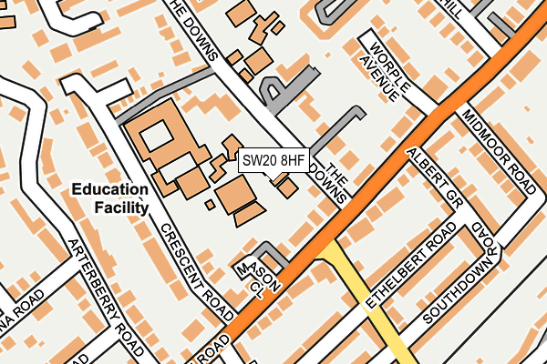
SW20 8HF lies on The Downs in London. SW20 8HF is located in the Raynes Park electoral ward, within the London borough of Merton and the English Parliamentary constituency of Wimbledon. The Sub Integrated Care Board (ICB) Location is NHS South West London ICB - 36L and the police force is Metropolitan Police. This postcode has been in use since January 1980.


GetTheData
Source: OS OpenMap – Local (Ordnance Survey)
Source: OS VectorMap District (Ordnance Survey)
Licence: Open Government Licence (requires attribution)
| Easting | 523758 |
| Northing | 169938 |
| Latitude | 51.414961 |
| Longitude | -0.221735 |
GetTheData
Source: Open Postcode Geo
Licence: Open Government Licence
| Street | The Downs |
| Town/City | London |
| Country | England |
| Postcode District | SW20 |
➜ See where SW20 is on a map ➜ Where is Wimbledon? | |
GetTheData
Source: Land Registry Price Paid Data
Licence: Open Government Licence
Elevation or altitude of SW20 8HF as distance above sea level:
| Metres | Feet | |
|---|---|---|
| Elevation | 30m | 98ft |
Elevation is measured from the approximate centre of the postcode, to the nearest point on an OS contour line from OS Terrain 50, which has contour spacing of ten vertical metres.
➜ How high above sea level am I? Find the elevation of your current position using your device's GPS.
GetTheData
Source: Open Postcode Elevation
Licence: Open Government Licence
| Ward | Raynes Park |
| Constituency | Wimbledon |
GetTheData
Source: ONS Postcode Database
Licence: Open Government Licence
17, THE DOWNS, LONDON, SW20 8HF 2019 22 AUG £4,388,210 |
17, THE DOWNS, LONDON, SW20 8HF 1998 21 DEC £1,500,000 |
GetTheData
Source: HM Land Registry Price Paid Data
Licence: Contains HM Land Registry data © Crown copyright and database right 2025. This data is licensed under the Open Government Licence v3.0.
| Lower Downs Road Wimbledon (Worple Road) | Bushey Mead | 142m |
| Lower Downs Road Wimbledon (Worple Road) | Bushey Mead | 153m |
| Albert Grove (Worple Road) | Bushey Mead | 159m |
| Albert Grove (Worple Road) | Bushey Mead | 166m |
| Arterberry Road (Worple Road) | Bushey Mead | 326m |
| Dundonald Road Tram Stop (Dundonald Road) | Wimbledon | 1,021m |
| Wimbledon Underground Station | Wimbledon | 1,264m |
| Wimbledon Tram Stop (The Broadway) | Wimbledon | 1,299m |
| Merton Park Tram Stop (Off Rutlish Road) | Merton | 1,437m |
| Wimbledon Chase Station | 0.8km |
| Raynes Park Station | 0.9km |
| Wimbledon Station | 1.3km |
GetTheData
Source: NaPTAN
Licence: Open Government Licence
GetTheData
Source: ONS Postcode Database
Licence: Open Government Licence


➜ Get more ratings from the Food Standards Agency
GetTheData
Source: Food Standards Agency
Licence: FSA terms & conditions
| Last Collection | |||
|---|---|---|---|
| Location | Mon-Fri | Sat | Distance |
| 24 The Downs | 16:00 | 12:00 | 101m |
| Stanton Road | 16:00 | 12:00 | 263m |
| 18a Arterberry Road | 16:00 | 12:00 | 267m |
GetTheData
Source: Dracos
Licence: Creative Commons Attribution-ShareAlike
The below table lists the International Territorial Level (ITL) codes (formerly Nomenclature of Territorial Units for Statistics (NUTS) codes) and Local Administrative Units (LAU) codes for SW20 8HF:
| ITL 1 Code | Name |
|---|---|
| TLI | London |
| ITL 2 Code | Name |
| TLI6 | Outer London - South |
| ITL 3 Code | Name |
| TLI63 | Merton, Kingston upon Thames and Sutton |
| LAU 1 Code | Name |
| E09000024 | Merton |
GetTheData
Source: ONS Postcode Directory
Licence: Open Government Licence
The below table lists the Census Output Area (OA), Lower Layer Super Output Area (LSOA), and Middle Layer Super Output Area (MSOA) for SW20 8HF:
| Code | Name | |
|---|---|---|
| OA | E00017446 | |
| LSOA | E01003442 | Merton 010A |
| MSOA | E02000698 | Merton 010 |
GetTheData
Source: ONS Postcode Directory
Licence: Open Government Licence
| SW20 8HX | The Downs | 69m |
| SW20 8HU | The Downs | 71m |
| SW20 8HY | The Downs | 75m |
| SW20 8HT | The Downs | 83m |
| SW20 8HZ | The Downs | 88m |
| SW20 8UA | The Downs | 93m |
| SW20 8JE | The Downs | 96m |
| SW20 8HB | Worple Road | 99m |
| SW20 8JA | The Downs | 105m |
| SW20 8HA | Crescent Road | 129m |
GetTheData
Source: Open Postcode Geo; Land Registry Price Paid Data
Licence: Open Government Licence