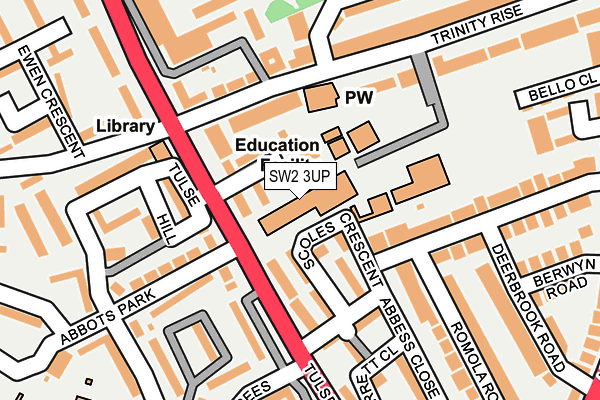
SW2 3UP is located in the St Martin's electoral ward, within the London borough of Lambeth and the English Parliamentary constituency of Dulwich and West Norwood. The Sub Integrated Care Board (ICB) Location is NHS South East London ICB - 72Q and the police force is Metropolitan Police. This postcode has been in use since January 1980.


GetTheData
Source: OS OpenMap – Local (Ordnance Survey)
Source: OS VectorMap District (Ordnance Survey)
Licence: Open Government Licence (requires attribution)
| Easting | 531466 |
| Northing | 173379 |
| Latitude | 51.444152 |
| Longitude | -0.109705 |
GetTheData
Source: Open Postcode Geo
Licence: Open Government Licence
| Country | England |
| Postcode District | SW2 |
➜ See where SW2 is on a map ➜ Where is London? | |
GetTheData
Source: Land Registry Price Paid Data
Licence: Open Government Licence
Elevation or altitude of SW2 3UP as distance above sea level:
| Metres | Feet | |
|---|---|---|
| Elevation | 50m | 164ft |
Elevation is measured from the approximate centre of the postcode, to the nearest point on an OS contour line from OS Terrain 50, which has contour spacing of ten vertical metres.
➜ How high above sea level am I? Find the elevation of your current position using your device's GPS.
GetTheData
Source: Open Postcode Elevation
Licence: Open Government Licence
| Ward | St Martin's |
| Constituency | Dulwich And West Norwood |
GetTheData
Source: ONS Postcode Database
Licence: Open Government Licence
| Upper Tulse Hill (Tulse Hill) | Tulse Hill | 115m |
| High Trees (Tulse Hill) | Tulse Hill | 133m |
| High Trees (Tulse Hill) | Tulse Hill | 160m |
| St Martins Estate (Upper Tulse Hill) | Tulse Hill | 192m |
| Upper Tulse Hill (Tulse Hill) | Tulse Hill | 210m |
| Tulse Hill Station | 0.6km |
| Herne Hill Station | 1.1km |
| West Dulwich Station | 1.3km |
GetTheData
Source: NaPTAN
Licence: Open Government Licence
GetTheData
Source: ONS Postcode Database
Licence: Open Government Licence


➜ Get more ratings from the Food Standards Agency
GetTheData
Source: Food Standards Agency
Licence: FSA terms & conditions
| Last Collection | |||
|---|---|---|---|
| Location | Mon-Fri | Sat | Distance |
| Abbots Park | 17:30 | 12:00 | 211m |
| Norwood Road | 17:30 | 12:00 | 325m |
| Tulse Hill | 17:30 | 12:00 | 350m |
GetTheData
Source: Dracos
Licence: Creative Commons Attribution-ShareAlike
The below table lists the International Territorial Level (ITL) codes (formerly Nomenclature of Territorial Units for Statistics (NUTS) codes) and Local Administrative Units (LAU) codes for SW2 3UP:
| ITL 1 Code | Name |
|---|---|
| TLI | London |
| ITL 2 Code | Name |
| TLI4 | Inner London - East |
| ITL 3 Code | Name |
| TLI45 | Lambeth |
| LAU 1 Code | Name |
| E09000022 | Lambeth |
GetTheData
Source: ONS Postcode Directory
Licence: Open Government Licence
The below table lists the Census Output Area (OA), Lower Layer Super Output Area (LSOA), and Middle Layer Super Output Area (MSOA) for SW2 3UP:
| Code | Name | |
|---|---|---|
| OA | E00016008 | |
| LSOA | E01003169 | Lambeth 025D |
| MSOA | E02000642 | Lambeth 025 |
GetTheData
Source: ONS Postcode Directory
Licence: Open Government Licence
| SW2 3UL | Skiffington Close | 33m |
| SW2 3UJ | Tulse Hill | 65m |
| SW2 3DT | Scoles Crescent | 77m |
| SW2 3UH | Ashurst Gardens | 92m |
| SW2 3DD | Talcott Path | 97m |
| SW2 3QE | Tulse Hill | 103m |
| SW2 3QF | Tulse Hill | 108m |
| SW2 3QA | Tulse Hill | 116m |
| SW2 3PJ | Tulse Hill | 129m |
| SW2 2QN | Ropers Walk | 133m |
GetTheData
Source: Open Postcode Geo; Land Registry Price Paid Data
Licence: Open Government Licence