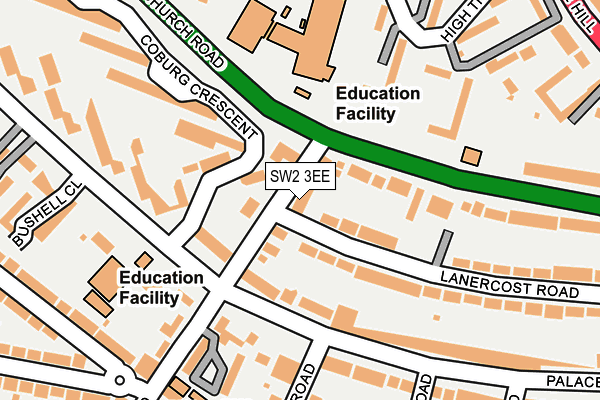
SW2 3EE lies on Hillside Road in London. SW2 3EE is located in the St Martin's electoral ward, within the London borough of Lambeth and the English Parliamentary constituency of Streatham. The Sub Integrated Care Board (ICB) Location is NHS South East London ICB - 72Q and the police force is Metropolitan Police. This postcode has been in use since January 1980.


GetTheData
Source: OS OpenMap – Local (Ordnance Survey)
Source: OS VectorMap District (Ordnance Survey)
Licence: Open Government Licence (requires attribution)
| Easting | 531235 |
| Northing | 172982 |
| Latitude | 51.440638 |
| Longitude | -0.113149 |
GetTheData
Source: Open Postcode Geo
Licence: Open Government Licence
| Street | Hillside Road |
| Town/City | London |
| Country | England |
| Postcode District | SW2 |
➜ See where SW2 is on a map ➜ Where is London? | |
GetTheData
Source: Land Registry Price Paid Data
Licence: Open Government Licence
Elevation or altitude of SW2 3EE as distance above sea level:
| Metres | Feet | |
|---|---|---|
| Elevation | 60m | 197ft |
Elevation is measured from the approximate centre of the postcode, to the nearest point on an OS contour line from OS Terrain 50, which has contour spacing of ten vertical metres.
➜ How high above sea level am I? Find the elevation of your current position using your device's GPS.
GetTheData
Source: Open Postcode Elevation
Licence: Open Government Licence
| Ward | St Martin's |
| Constituency | Streatham |
GetTheData
Source: ONS Postcode Database
Licence: Open Government Licence
1, HILLSIDE ROAD, LONDON, SW2 3EE 2022 29 JUL £2,200,000 |
2, HILLSIDE ROAD, LONDON, SW2 3EE 1997 11 JUL £252,000 |
GetTheData
Source: HM Land Registry Price Paid Data
Licence: Contains HM Land Registry data © Crown copyright and database right 2025. This data is licensed under the Open Government Licence v3.0.
| Lanercost Road (Hillside Avenue) | Tulse Hill | 41m |
| Christchurch Road Hillside Rd (Christchurch Road) | Tulse Hill | 66m |
| Christchurch Road Hillside Rd (Christchurch Road) | Tulse Hill | 152m |
| Palace Road (Sw2) (Hillside Avenue) | Tulse Hill | 168m |
| Palace Road (Sw2) (Hillside Avenue) | Tulse Hill | 216m |
| Tulse Hill Station | 0.6km |
| Streatham Hill Station | 1km |
| West Norwood Station | 1.2km |
GetTheData
Source: NaPTAN
Licence: Open Government Licence
| Percentage of properties with Next Generation Access | 100.0% |
| Percentage of properties with Superfast Broadband | 100.0% |
| Percentage of properties with Ultrafast Broadband | 50.0% |
| Percentage of properties with Full Fibre Broadband | 0.0% |
Superfast Broadband is between 30Mbps and 300Mbps
Ultrafast Broadband is > 300Mbps
| Percentage of properties unable to receive 2Mbps | 0.0% |
| Percentage of properties unable to receive 5Mbps | 0.0% |
| Percentage of properties unable to receive 10Mbps | 0.0% |
| Percentage of properties unable to receive 30Mbps | 0.0% |
GetTheData
Source: Ofcom
Licence: Ofcom Terms of Use (requires attribution)
GetTheData
Source: ONS Postcode Database
Licence: Open Government Licence


➜ Get more ratings from the Food Standards Agency
GetTheData
Source: Food Standards Agency
Licence: FSA terms & conditions
| Last Collection | |||
|---|---|---|---|
| Location | Mon-Fri | Sat | Distance |
| Palace Road | 17:30 | 12:00 | 126m |
| 98 Christchurch Road | 17:30 | 12:00 | 177m |
| Palace Road | 17:30 | 12:00 | 221m |
GetTheData
Source: Dracos
Licence: Creative Commons Attribution-ShareAlike
The below table lists the International Territorial Level (ITL) codes (formerly Nomenclature of Territorial Units for Statistics (NUTS) codes) and Local Administrative Units (LAU) codes for SW2 3EE:
| ITL 1 Code | Name |
|---|---|
| TLI | London |
| ITL 2 Code | Name |
| TLI4 | Inner London - East |
| ITL 3 Code | Name |
| TLI45 | Lambeth |
| LAU 1 Code | Name |
| E09000022 | Lambeth |
GetTheData
Source: ONS Postcode Directory
Licence: Open Government Licence
The below table lists the Census Output Area (OA), Lower Layer Super Output Area (LSOA), and Middle Layer Super Output Area (MSOA) for SW2 3EE:
| Code | Name | |
|---|---|---|
| OA | E00015808 | |
| LSOA | E01003133 | Lambeth 027C |
| MSOA | E02000644 | Lambeth 027 |
GetTheData
Source: ONS Postcode Directory
Licence: Open Government Licence
| SW2 3EY | Christchurch Road | 41m |
| SW2 3DE | Christchurch Road | 58m |
| SW2 3DR | Lanercost Road | 59m |
| SW2 3EH | Hillside Road | 70m |
| SW2 3ED | Palace Road | 106m |
| SW2 3HU | Coburg Crescent | 133m |
| SW2 3DS | Lanercost Close | 133m |
| SW2 3EW | Palace Road | 147m |
| SW2 3NP | Palace Road | 167m |
| SW2 3PF | Tulse Hill | 174m |
GetTheData
Source: Open Postcode Geo; Land Registry Price Paid Data
Licence: Open Government Licence