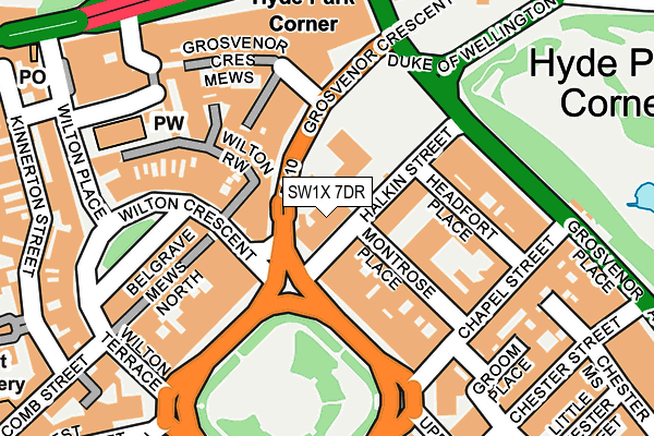
SW1X 7DR is located in the Knightsbridge & Belgravia electoral ward, within the London borough of Westminster and the English Parliamentary constituency of Cities of London and Westminster. The Sub Integrated Care Board (ICB) Location is NHS North West London ICB - W2U3Z and the police force is Metropolitan Police. This postcode has been in use since January 1980.


GetTheData
Source: OS OpenMap – Local (Ordnance Survey)
Source: OS VectorMap District (Ordnance Survey)
Licence: Open Government Licence (requires attribution)
| Easting | 528302 |
| Northing | 179593 |
| Latitude | 51.500721 |
| Longitude | -0.152953 |
GetTheData
Source: Open Postcode Geo
Licence: Open Government Licence
| Country | England |
| Postcode District | SW1X |
➜ See where SW1X is on a map ➜ Where is City of Westminster? | |
GetTheData
Source: Land Registry Price Paid Data
Licence: Open Government Licence
Elevation or altitude of SW1X 7DR as distance above sea level:
| Metres | Feet | |
|---|---|---|
| Elevation | 10m | 33ft |
Elevation is measured from the approximate centre of the postcode, to the nearest point on an OS contour line from OS Terrain 50, which has contour spacing of ten vertical metres.
➜ How high above sea level am I? Find the elevation of your current position using your device's GPS.
GetTheData
Source: Open Postcode Elevation
Licence: Open Government Licence
| Ward | Knightsbridge & Belgravia |
| Constituency | Cities Of London And Westminster |
GetTheData
Source: ONS Postcode Database
Licence: Open Government Licence
| Hyde Park Corner (Grosvenor Place) | Hyde Park Corner | 150m |
| Grosvenor Place Hyde Park Corner (Grosvenor Place) | Hyde Park Corner | 185m |
| Hyde Park Corner (Duke Of Wellington Place) | Hyde Park Corner | 219m |
| Hyde Park Corner (Knightsbridge) | Hyde Park Corner | 221m |
| Hyde Park Corner (Knightsbridge) | Hyde Park Corner | 224m |
| Hyde Park Corner Underground Station | Hyde Park Corner | 260m |
| Knightsbridge Underground Station | Knightsbridge | 535m |
| Victoria Underground Station | Victoria | 839m |
| Sloane Square Underground Station | Sloane Square | 970m |
| Green Park Underground Station | Green Park | 989m |
| London Victoria Station | 0.8km |
| London Charing Cross Station | 2.1km |
| London Paddington Station | 2.3km |
GetTheData
Source: NaPTAN
Licence: Open Government Licence
GetTheData
Source: ONS Postcode Database
Licence: Open Government Licence


➜ Get more ratings from the Food Standards Agency
GetTheData
Source: Food Standards Agency
Licence: FSA terms & conditions
| Last Collection | |||
|---|---|---|---|
| Location | Mon-Fri | Sat | Distance |
| Wilton Crescent | 18:30 | 11:30 | 122m |
| Chapel Street | 18:30 | 11:30 | 187m |
| Belgrave Square | 18:30 | 11:30 | 194m |
GetTheData
Source: Dracos
Licence: Creative Commons Attribution-ShareAlike
The below table lists the International Territorial Level (ITL) codes (formerly Nomenclature of Territorial Units for Statistics (NUTS) codes) and Local Administrative Units (LAU) codes for SW1X 7DR:
| ITL 1 Code | Name |
|---|---|
| TLI | London |
| ITL 2 Code | Name |
| TLI3 | Inner London - West |
| ITL 3 Code | Name |
| TLI32 | Westminster |
| LAU 1 Code | Name |
| E09000033 | Westminster |
GetTheData
Source: ONS Postcode Directory
Licence: Open Government Licence
The below table lists the Census Output Area (OA), Lower Layer Super Output Area (LSOA), and Middle Layer Super Output Area (MSOA) for SW1X 7DR:
| Code | Name | |
|---|---|---|
| OA | E00023669 | |
| LSOA | E01004691 | Westminster 019E |
| MSOA | E02000978 | Westminster 019 |
GetTheData
Source: ONS Postcode Directory
Licence: Open Government Licence
| SW1X 7DJ | Halkin Street | 57m |
| SW1X 7EE | Grosvenor Crescent | 74m |
| SW1X 7DT | Montrose Place | 84m |
| SW1X 7ET | Pembroke Close | 93m |
| SW1X 7DU | Montrose Place | 97m |
| SW1X 7DE | Headfort Place | 115m |
| SW1X 7NS | Wilton Row | 123m |
| SW1X 7EU | Grosvenor Crescent Mews | 125m |
| SW1X 7SH | Grosvenor Place | 138m |
| SW1X 7NR | Wilton Row | 138m |
GetTheData
Source: Open Postcode Geo; Land Registry Price Paid Data
Licence: Open Government Licence