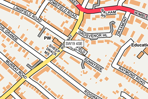
SW19 4SE lies on Linden Cottages in London. SW19 4SE is located in the Village electoral ward, within the London borough of Merton and the English Parliamentary constituency of Wimbledon. The Sub Integrated Care Board (ICB) Location is NHS South West London ICB - 36L and the police force is Metropolitan Police. This postcode has been in use since January 1980.


GetTheData
Source: OS OpenMap – Local (Ordnance Survey)
Source: OS VectorMap District (Ordnance Survey)
Licence: Open Government Licence (requires attribution)
| Easting | 524119 |
| Northing | 170816 |
| Latitude | 51.422773 |
| Longitude | -0.216239 |
GetTheData
Source: Open Postcode Geo
Licence: Open Government Licence
| Street | Linden Cottages |
| Town/City | London |
| Country | England |
| Postcode District | SW19 |
➜ See where SW19 is on a map ➜ Where is Wimbledon? | |
GetTheData
Source: Land Registry Price Paid Data
Licence: Open Government Licence
Elevation or altitude of SW19 4SE as distance above sea level:
| Metres | Feet | |
|---|---|---|
| Elevation | 50m | 164ft |
Elevation is measured from the approximate centre of the postcode, to the nearest point on an OS contour line from OS Terrain 50, which has contour spacing of ten vertical metres.
➜ How high above sea level am I? Find the elevation of your current position using your device's GPS.
GetTheData
Source: Open Postcode Elevation
Licence: Open Government Licence
| Ward | Village |
| Constituency | Wimbledon |
GetTheData
Source: ONS Postcode Database
Licence: Open Government Licence
| Wimbledon Village Ridgway (Ridgway) | Wimbledon | 117m |
| Wimbledon Village Ridgway (Ridgway) | Wimbledon | 129m |
| Wimbledon Telephone Exchange (Ridgway) | Wimbledon | 197m |
| High Street Wimbledon Village (Wimbledon High Street) | Wimbledon | 215m |
| High Street Wimbledon Village (Wimbledon High Street) | Wimbledon | 226m |
| Wimbledon Underground Station | Wimbledon | 696m |
| Wimbledon Tram Stop (The Broadway) | Wimbledon | 751m |
| Dundonald Road Tram Stop (Dundonald Road) | Wimbledon | 833m |
| Merton Park Tram Stop (Off Rutlish Road) | Merton | 1,463m |
| Wimbledon Park Underground Station | Wimbledon Park | 1,745m |
| Wimbledon Station | 0.7km |
| Wimbledon Chase Station | 1.5km |
| Raynes Park Station | 1.8km |
GetTheData
Source: NaPTAN
Licence: Open Government Licence
| Percentage of properties with Next Generation Access | 100.0% |
| Percentage of properties with Superfast Broadband | 100.0% |
| Percentage of properties with Ultrafast Broadband | 0.0% |
| Percentage of properties with Full Fibre Broadband | 0.0% |
Superfast Broadband is between 30Mbps and 300Mbps
Ultrafast Broadband is > 300Mbps
| Percentage of properties unable to receive 2Mbps | 0.0% |
| Percentage of properties unable to receive 5Mbps | 0.0% |
| Percentage of properties unable to receive 10Mbps | 0.0% |
| Percentage of properties unable to receive 30Mbps | 0.0% |
GetTheData
Source: Ofcom
Licence: Ofcom Terms of Use (requires attribution)
GetTheData
Source: ONS Postcode Database
Licence: Open Government Licence


➜ Get more ratings from the Food Standards Agency
GetTheData
Source: Food Standards Agency
Licence: FSA terms & conditions
| Last Collection | |||
|---|---|---|---|
| Location | Mon-Fri | Sat | Distance |
| 36 Ridgway | 17:30 | 12:00 | 131m |
| 44 Raymond Road | 17:30 | 12:00 | 182m |
| Belvedere Grove | 17:30 | 12:00 | 198m |
GetTheData
Source: Dracos
Licence: Creative Commons Attribution-ShareAlike
The below table lists the International Territorial Level (ITL) codes (formerly Nomenclature of Territorial Units for Statistics (NUTS) codes) and Local Administrative Units (LAU) codes for SW19 4SE:
| ITL 1 Code | Name |
|---|---|
| TLI | London |
| ITL 2 Code | Name |
| TLI6 | Outer London - South |
| ITL 3 Code | Name |
| TLI63 | Merton, Kingston upon Thames and Sutton |
| LAU 1 Code | Name |
| E09000024 | Merton |
GetTheData
Source: ONS Postcode Directory
Licence: Open Government Licence
The below table lists the Census Output Area (OA), Lower Layer Super Output Area (LSOA), and Middle Layer Super Output Area (MSOA) for SW19 4SE:
| Code | Name | |
|---|---|---|
| OA | E00017541 | |
| LSOA | E01003461 | Merton 004E |
| MSOA | E02000692 | Merton 004 |
GetTheData
Source: ONS Postcode Directory
Licence: Open Government Licence
| SW19 4SF | Ridgway | 28m |
| SW19 4SD | Oldfield Road | 34m |
| SW19 4SB | Ridgway | 43m |
| SW19 4SL | Sunnyside | 48m |
| SW19 4SN | Ridgway | 52m |
| SW19 4SA | Grosvenor Hill | 55m |
| SW19 4QL | Sheep Walk Mews | 71m |
| SW19 4QW | Ridgway | 81m |
| SW19 4RZ | Grosvenor Hill | 85m |
| SW19 4RT | Grosvenor Hill | 88m |
GetTheData
Source: Open Postcode Geo; Land Registry Price Paid Data
Licence: Open Government Licence