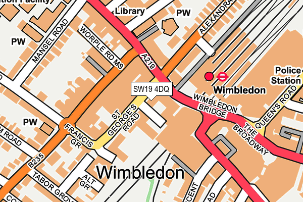
SW19 4DQ is located in the Hillside electoral ward, within the London borough of Merton and the English Parliamentary constituency of Wimbledon. The Sub Integrated Care Board (ICB) Location is NHS South West London ICB - 36L and the police force is Metropolitan Police. This postcode has been in use since April 1986.


GetTheData
Source: OS OpenMap – Local (Ordnance Survey)
Source: OS VectorMap District (Ordnance Survey)
Licence: Open Government Licence (requires attribution)
| Easting | 524703 |
| Northing | 170633 |
| Latitude | 51.421000 |
| Longitude | -0.207908 |
GetTheData
Source: Open Postcode Geo
Licence: Open Government Licence
| Country | England |
| Postcode District | SW19 |
➜ See where SW19 is on a map ➜ Where is Wimbledon? | |
GetTheData
Source: Land Registry Price Paid Data
Licence: Open Government Licence
Elevation or altitude of SW19 4DQ as distance above sea level:
| Metres | Feet | |
|---|---|---|
| Elevation | 20m | 66ft |
Elevation is measured from the approximate centre of the postcode, to the nearest point on an OS contour line from OS Terrain 50, which has contour spacing of ten vertical metres.
➜ How high above sea level am I? Find the elevation of your current position using your device's GPS.
GetTheData
Source: Open Postcode Elevation
Licence: Open Government Licence
| Ward | Hillside |
| Constituency | Wimbledon |
GetTheData
Source: ONS Postcode Database
Licence: Open Government Licence
| Wimbledon (Wimbledon Bridge) | Wimbledon | 84m |
| Wimbledon (Wimbledon Bridge) | Wimbledon | 102m |
| Francis Grove (Worple Road) | Wimbledon | 107m |
| Alexandra Rd Wimbledon Stn (Alexandra Road) | Wimbledon | 113m |
| Wimbledon | Wimbledon | 113m |
| Wimbledon Underground Station | Wimbledon | 97m |
| Wimbledon Tram Stop (The Broadway) | Wimbledon | 147m |
| Dundonald Road Tram Stop (Dundonald Road) | Wimbledon | 384m |
| Merton Park Tram Stop (Off Rutlish Road) | Merton | 948m |
| South Wimbledon Underground Station | South Wimbledon | 1,276m |
| Wimbledon Station | 0.1km |
| Wimbledon Chase Station | 1.3km |
| Haydons Road Station | 1.4km |
GetTheData
Source: NaPTAN
Licence: Open Government Licence
GetTheData
Source: ONS Postcode Database
Licence: Open Government Licence


➜ Get more ratings from the Food Standards Agency
GetTheData
Source: Food Standards Agency
Licence: FSA terms & conditions
| Last Collection | |||
|---|---|---|---|
| Location | Mon-Fri | Sat | Distance |
| Wimbledon Station Approach | 17:30 | 12:00 | 85m |
| Post Office | 17:30 | 12:00 | 94m |
| Post Ofice | 17:30 | 12:00 | 191m |
GetTheData
Source: Dracos
Licence: Creative Commons Attribution-ShareAlike
The below table lists the International Territorial Level (ITL) codes (formerly Nomenclature of Territorial Units for Statistics (NUTS) codes) and Local Administrative Units (LAU) codes for SW19 4DQ:
| ITL 1 Code | Name |
|---|---|
| TLI | London |
| ITL 2 Code | Name |
| TLI6 | Outer London - South |
| ITL 3 Code | Name |
| TLI63 | Merton, Kingston upon Thames and Sutton |
| LAU 1 Code | Name |
| E09000024 | Merton |
GetTheData
Source: ONS Postcode Directory
Licence: Open Government Licence
The below table lists the Census Output Area (OA), Lower Layer Super Output Area (LSOA), and Middle Layer Super Output Area (MSOA) for SW19 4DQ:
| Code | Name | |
|---|---|---|
| OA | E00017226 | |
| LSOA | E01003402 | Merton 004B |
| MSOA | E02000692 | Merton 004 |
GetTheData
Source: ONS Postcode Directory
Licence: Open Government Licence
| SW19 7NF | Wimbledon Hill Road | 59m |
| SW19 7NE | Wimbledon Hill Road | 101m |
| SW19 4DA | The Pavement | 109m |
| SW19 4BG | Worple Road | 131m |
| SW19 4BH | Worple Road | 131m |
| SW19 4BJ | Worple Road | 131m |
| SW19 7ND | St Marks Place | 135m |
| SW19 3TA | Hartfield Road | 140m |
| SW19 4DL | Francis Grove | 153m |
| SW19 4DB | Worple Road Mews | 154m |
GetTheData
Source: Open Postcode Geo; Land Registry Price Paid Data
Licence: Open Government Licence