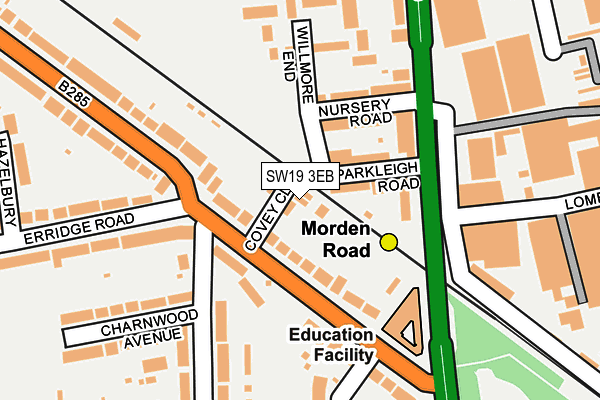
SW19 3EB lies on Covey Close in London. SW19 3EB is located in the Merton Park electoral ward, within the London borough of Merton and the English Parliamentary constituency of Wimbledon. The Sub Integrated Care Board (ICB) Location is NHS South West London ICB - 36L and the police force is Metropolitan Police. This postcode has been in use since June 1998.


GetTheData
Source: OS OpenMap – Local (Ordnance Survey)
Source: OS VectorMap District (Ordnance Survey)
Licence: Open Government Licence (requires attribution)
| Easting | 525687 |
| Northing | 169354 |
| Latitude | 51.409289 |
| Longitude | -0.194241 |
GetTheData
Source: Open Postcode Geo
Licence: Open Government Licence
| Street | Covey Close |
| Town/City | London |
| Country | England |
| Postcode District | SW19 |
➜ See where SW19 is on a map ➜ Where is London? | |
GetTheData
Source: Land Registry Price Paid Data
Licence: Open Government Licence
Elevation or altitude of SW19 3EB as distance above sea level:
| Metres | Feet | |
|---|---|---|
| Elevation | 20m | 66ft |
Elevation is measured from the approximate centre of the postcode, to the nearest point on an OS contour line from OS Terrain 50, which has contour spacing of ten vertical metres.
➜ How high above sea level am I? Find the elevation of your current position using your device's GPS.
GetTheData
Source: Open Postcode Elevation
Licence: Open Government Licence
| Ward | Merton Park |
| Constituency | Wimbledon |
GetTheData
Source: ONS Postcode Database
Licence: Open Government Licence
5, COVEY CLOSE, LONDON, SW19 3EB 2024 13 NOV £600,000 |
2013 12 DEC £395,000 |
1998 7 AUG £134,950 |
1, COVEY CLOSE, LONDON, SW19 3EB 1998 16 JAN £169,950 |
GetTheData
Source: HM Land Registry Price Paid Data
Licence: Contains HM Land Registry data © Crown copyright and database right 2025. This data is licensed under the Open Government Licence v3.0.
| Morden Road Tram Stop (Morden Road) | Merton Park | 123m |
| Morden Road Tram Stop (Morden Road) | Merton Park | 213m |
| Dorset Road Morden (Morden Road) | Morden | 268m |
| Dorset Road Morden (Morden Road) | Morden | 324m |
| Kenley Road Circle Gardens | Merton Park | 463m |
| Morden Road Tram Stop (Morden Road) | Merton Park | 108m |
| Merton Park Tram Stop (Off Rutlish Road) | Merton | 681m |
| South Wimbledon Underground Station | South Wimbledon | 687m |
| Morden Underground Station | Morden | 796m |
| Phipps Bridge Tram Stop (New Close-phipps Bridge) | Morden | 1,059m |
| South Merton Station | 1km |
| Wimbledon Chase Station | 1.4km |
| Morden South Station | 1.5km |
GetTheData
Source: NaPTAN
Licence: Open Government Licence
| Percentage of properties with Next Generation Access | 100.0% |
| Percentage of properties with Superfast Broadband | 100.0% |
| Percentage of properties with Ultrafast Broadband | 100.0% |
| Percentage of properties with Full Fibre Broadband | 100.0% |
Superfast Broadband is between 30Mbps and 300Mbps
Ultrafast Broadband is > 300Mbps
| Percentage of properties unable to receive 2Mbps | 0.0% |
| Percentage of properties unable to receive 5Mbps | 0.0% |
| Percentage of properties unable to receive 10Mbps | 0.0% |
| Percentage of properties unable to receive 30Mbps | 0.0% |
GetTheData
Source: Ofcom
Licence: Ofcom Terms of Use (requires attribution)
GetTheData
Source: ONS Postcode Database
Licence: Open Government Licence


➜ Get more ratings from the Food Standards Agency
GetTheData
Source: Food Standards Agency
Licence: FSA terms & conditions
| Last Collection | |||
|---|---|---|---|
| Location | Mon-Fri | Sat | Distance |
| 2 Erridge Road | 17:30 | 12:00 | 109m |
| Parkleigh Road | 17:30 | 12:00 | 123m |
| Lombard Road | 17:30 | 12:00 | 229m |
GetTheData
Source: Dracos
Licence: Creative Commons Attribution-ShareAlike
The below table lists the International Territorial Level (ITL) codes (formerly Nomenclature of Territorial Units for Statistics (NUTS) codes) and Local Administrative Units (LAU) codes for SW19 3EB:
| ITL 1 Code | Name |
|---|---|
| TLI | London |
| ITL 2 Code | Name |
| TLI6 | Outer London - South |
| ITL 3 Code | Name |
| TLI63 | Merton, Kingston upon Thames and Sutton |
| LAU 1 Code | Name |
| E09000024 | Merton |
GetTheData
Source: ONS Postcode Directory
Licence: Open Government Licence
The below table lists the Census Output Area (OA), Lower Layer Super Output Area (LSOA), and Middle Layer Super Output Area (MSOA) for SW19 3EB:
| Code | Name | |
|---|---|---|
| OA | E00017326 | |
| LSOA | E01003426 | Merton 015D |
| MSOA | E02000703 | Merton 015 |
GetTheData
Source: ONS Postcode Directory
Licence: Open Government Licence
| SW19 3EF | Dorset Road | 64m |
| SW19 3BU | Parkleigh Road | 64m |
| SW19 3BT | Nursery Road | 92m |
| SW19 3BX | Morden Road | 107m |
| SW19 3EQ | Dorset Road | 132m |
| SW19 3BP | Morden Road | 135m |
| SW19 3DE | Willmore End | 164m |
| SW19 3DF | Willmore End | 184m |
| SW19 3EH | Sandbourne Avenue | 191m |
| SW19 3EJ | Charnwood Avenue | 213m |
GetTheData
Source: Open Postcode Geo; Land Registry Price Paid Data
Licence: Open Government Licence