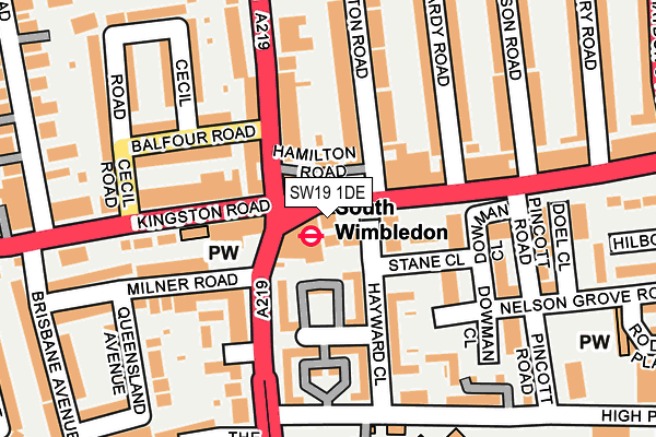
SW19 1DE is located in the Abbey electoral ward, within the London borough of Merton and the English Parliamentary constituency of Wimbledon. The Sub Integrated Care Board (ICB) Location is NHS South West London ICB - 36L and the police force is Metropolitan Police. This postcode has been in use since January 1980.


GetTheData
Source: OS OpenMap – Local (Ordnance Survey)
Source: OS VectorMap District (Ordnance Survey)
Licence: Open Government Licence (requires attribution)
| Easting | 525844 |
| Northing | 170049 |
| Latitude | 51.415501 |
| Longitude | -0.191739 |
GetTheData
Source: Open Postcode Geo
Licence: Open Government Licence
| Country | England |
| Postcode District | SW19 |
➜ See where SW19 is on a map ➜ Where is Merton? | |
GetTheData
Source: Land Registry Price Paid Data
Licence: Open Government Licence
Elevation or altitude of SW19 1DE as distance above sea level:
| Metres | Feet | |
|---|---|---|
| Elevation | 20m | 66ft |
Elevation is measured from the approximate centre of the postcode, to the nearest point on an OS contour line from OS Terrain 50, which has contour spacing of ten vertical metres.
➜ How high above sea level am I? Find the elevation of your current position using your device's GPS.
GetTheData
Source: Open Postcode Elevation
Licence: Open Government Licence
| Ward | Abbey |
| Constituency | Wimbledon |
GetTheData
Source: ONS Postcode Database
Licence: Open Government Licence
| South Wimbledon (Merton High Street) | South Wimbledon | 14m |
| South Wimbledon (Merton High Street) | South Wimbledon | 30m |
| Morden Rd South Wimbledon Stn (Morden Road) | Merton | 99m |
| Morden Rd South Wimbledon Stn (Morden Road) | Merton | 119m |
| Morden Road Kingston Road (Kingston Road) | Merton | 121m |
| South Wimbledon Underground Station | South Wimbledon | 28m |
| Merton Park Tram Stop (Off Rutlish Road) | Merton | 693m |
| Morden Road Tram Stop (Morden Road) | Merton Park | 741m |
| Colliers Wood Underground Station | Collier's Wood | 995m |
| Dundonald Road Tram Stop (Dundonald Road) | Wimbledon | 1,132m |
| Haydons Road Station | 1.1km |
| Wimbledon Station | 1.2km |
| South Merton Station | 1.7km |
GetTheData
Source: NaPTAN
Licence: Open Government Licence
| Percentage of properties with Next Generation Access | 100.0% |
| Percentage of properties with Superfast Broadband | 100.0% |
| Percentage of properties with Ultrafast Broadband | 0.0% |
| Percentage of properties with Full Fibre Broadband | 0.0% |
Superfast Broadband is between 30Mbps and 300Mbps
Ultrafast Broadband is > 300Mbps
| Percentage of properties unable to receive 2Mbps | 0.0% |
| Percentage of properties unable to receive 5Mbps | 0.0% |
| Percentage of properties unable to receive 10Mbps | 0.0% |
| Percentage of properties unable to receive 30Mbps | 0.0% |
GetTheData
Source: Ofcom
Licence: Ofcom Terms of Use (requires attribution)
GetTheData
Source: ONS Postcode Database
Licence: Open Government Licence


➜ Get more ratings from the Food Standards Agency
GetTheData
Source: Food Standards Agency
Licence: FSA terms & conditions
| Last Collection | |||
|---|---|---|---|
| Location | Mon-Fri | Sat | Distance |
| Balfour Road | 17:30 | 12:00 | 107m |
| 85 Merton High Street | 17:30 | 12:00 | 148m |
| Griffiths Road | 17:30 | 12:00 | 402m |
GetTheData
Source: Dracos
Licence: Creative Commons Attribution-ShareAlike
The below table lists the International Territorial Level (ITL) codes (formerly Nomenclature of Territorial Units for Statistics (NUTS) codes) and Local Administrative Units (LAU) codes for SW19 1DE:
| ITL 1 Code | Name |
|---|---|
| TLI | London |
| ITL 2 Code | Name |
| TLI6 | Outer London - South |
| ITL 3 Code | Name |
| TLI63 | Merton, Kingston upon Thames and Sutton |
| LAU 1 Code | Name |
| E09000024 | Merton |
GetTheData
Source: ONS Postcode Directory
Licence: Open Government Licence
The below table lists the Census Output Area (OA), Lower Layer Super Output Area (LSOA), and Middle Layer Super Output Area (MSOA) for SW19 1DE:
| Code | Name | |
|---|---|---|
| OA | E00016977 | |
| LSOA | E01003360 | Merton 006B |
| MSOA | E02000694 | Merton 006 |
GetTheData
Source: ONS Postcode Directory
Licence: Open Government Licence
| SW19 1AU | Merton High Street | 32m |
| SW19 2XJ | Hayward Close | 37m |
| SW19 3BH | Morden Road | 73m |
| SW19 2TH | Becket Close | 79m |
| SW19 1AX | Merton High Street | 85m |
| SW19 2XQ | Stane Close | 89m |
| SW19 2TQ | Gilbert Close | 90m |
| SW19 1EQ | Merton Road | 95m |
| SW19 2LF | Pincott Road | 128m |
| SW19 1JX | Kingston Road | 137m |
GetTheData
Source: Open Postcode Geo; Land Registry Price Paid Data
Licence: Open Government Licence