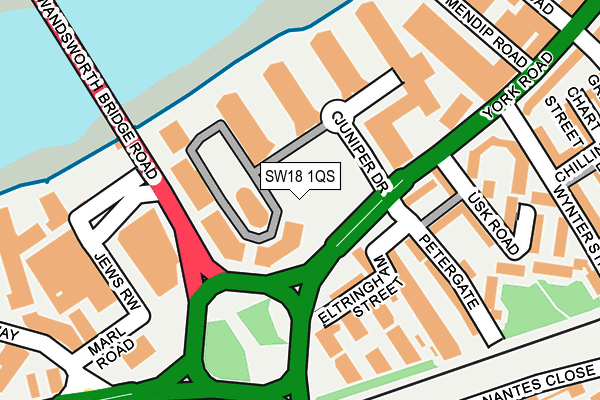
SW18 1QS is located in the St Mary's electoral ward, within the London borough of Wandsworth and the English Parliamentary constituency of Battersea. The Sub Integrated Care Board (ICB) Location is NHS South West London ICB - 36L and the police force is Metropolitan Police. This postcode has been in use since April 2017.


GetTheData
Source: OS OpenMap – Local (Ordnance Survey)
Source: OS VectorMap District (Ordnance Survey)
Licence: Open Government Licence (requires attribution)
| Easting | 526189 |
| Northing | 175417 |
| Latitude | 51.463667 |
| Longitude | -0.184844 |
GetTheData
Source: Open Postcode Geo
Licence: Open Government Licence
| Country | England |
| Postcode District | SW18 |
| ➜ SW18 open data dashboard ➜ See where SW18 is on a map ➜ Where is London? | |
GetTheData
Source: Land Registry Price Paid Data
Licence: Open Government Licence
| Ward | St Mary's |
| Constituency | Battersea |
GetTheData
Source: ONS Postcode Database
Licence: Open Government Licence
| January 2024 | Vehicle crime | On or near Lovetts Place | 421m |
| January 2024 | Vehicle crime | On or near Lovetts Place | 421m |
| December 2023 | Violence and sexual offences | On or near Hibbert Street | 341m |
| ➜ Get more crime data in our Crime section | |||
GetTheData
Source: data.police.uk
Licence: Open Government Licence
| Petergate (York Road) | Wandsworth | 93m |
| Bridgend Road | Wandsworth | 98m |
| Petergate (York Road) | Wandsworth | 103m |
| Bridgend Road | Wandsworth | 127m |
| Swandon Way | Wandsworth | 232m |
| Parsons Green Underground Station | Parsons Green | 1,718m |
| Wandsworth Town Station | 0.4km |
| Clapham Junction Station | 1km |
| Imperial Wharf Station | 1.3km |
GetTheData
Source: NaPTAN
Licence: Open Government Licence
➜ Broadband speed and availability dashboard for SW18 1QS
| Percentage of properties with Next Generation Access | 100.0% |
| Percentage of properties with Superfast Broadband | 100.0% |
| Percentage of properties with Ultrafast Broadband | 100.0% |
| Percentage of properties with Full Fibre Broadband | 100.0% |
Superfast Broadband is between 30Mbps and 300Mbps
Ultrafast Broadband is > 300Mbps
| Median download speed | 58.0Mbps |
| Average download speed | 58.0Mbps |
| Maximum download speed | 58.01Mbps |
| Median upload speed | 7.7Mbps |
| Average upload speed | 7.7Mbps |
| Maximum upload speed | 7.71Mbps |
| Percentage of properties unable to receive 2Mbps | 0.0% |
| Percentage of properties unable to receive 5Mbps | 0.0% |
| Percentage of properties unable to receive 10Mbps | 0.0% |
| Percentage of properties unable to receive 30Mbps | 0.0% |
➜ Broadband speed and availability dashboard for SW18 1QS
GetTheData
Source: Ofcom
Licence: Ofcom Terms of Use (requires attribution)
GetTheData
Source: ONS Postcode Database
Licence: Open Government Licence


➜ Get more ratings from the Food Standards Agency
GetTheData
Source: Food Standards Agency
Licence: FSA terms & conditions
| Last Collection | |||
|---|---|---|---|
| Location | Mon-Fri | Sat | Distance |
| York Road | 17:30 | 12:00 | 132m |
| Old York Road | 17:30 | 12:00 | 370m |
| 200 York Road | 17:30 | 12:00 | 396m |
GetTheData
Source: Dracos
Licence: Creative Commons Attribution-ShareAlike
| Facility | Distance |
|---|---|
| Battersea Sports Centre Hope Street, London Sports Hall, Health and Fitness Gym, Artificial Grass Pitch, Studio | 383m |
| Virgin Active (Wandsworth Smugglers Way) Smugglers Way, London Swimming Pool, Health and Fitness Gym, Studio | 396m |
| Anytime Fitness (London Fulham) Peterborough Road, London Health and Fitness Gym, Studio | 630m |
GetTheData
Source: Active Places
Licence: Open Government Licence
| School | Phase of Education | Distance |
|---|---|---|
| St Faith's CofE Primary School Alma Road, East Hill, London, SW18 1AE | Primary | 494m |
| Thomas's Fulham Hugon Road, Fulham, London, SW6 3ES | Not applicable | 683m |
| Park House School 48 North Side, Wandsworth Common, London, London, SW18 2SL | Not applicable | 717m |
GetTheData
Source: Edubase
Licence: Open Government Licence
| Risk of SW18 1QS flooding from rivers and sea | Very Low |
| ➜ SW18 1QS flood map | |
GetTheData
Source: Open Flood Risk by Postcode
Licence: Open Government Licence
The below table lists the International Territorial Level (ITL) codes (formerly Nomenclature of Territorial Units for Statistics (NUTS) codes) and Local Administrative Units (LAU) codes for SW18 1QS:
| ITL 1 Code | Name |
|---|---|
| TLI | London |
| ITL 2 Code | Name |
| TLI3 | Inner London - West |
| ITL 3 Code | Name |
| TLI34 | Wandsworth |
| LAU 1 Code | Name |
| E09000032 | Wandsworth |
GetTheData
Source: ONS Postcode Directory
Licence: Open Government Licence
The below table lists the Census Output Area (OA), Lower Layer Super Output Area (LSOA), and Middle Layer Super Output Area (MSOA) for SW18 1QS:
| Code | Name | |
|---|---|---|
| OA | E00171082 | |
| LSOA | E01033101 | Wandsworth 004F |
| MSOA | E02000926 | Wandsworth 004 |
GetTheData
Source: ONS Postcode Directory
Licence: Open Government Licence
| SW18 1GY | Juniper Drive | 58m |
| SW18 1TS | Juniper Drive | 73m |
| SW18 1TT | Juniper Drive | 73m |
| SW18 1GX | Juniper Drive | 78m |
| SW18 1TW | Juniper Drive | 91m |
| SW18 1TZ | Juniper Drive | 91m |
| SW18 1FR | Juniper Drive | 93m |
| SW18 1FS | Juniper Drive | 93m |
| SW18 1GJ | Juniper Drive | 114m |
| SW18 1GL | Juniper Drive | 114m |
GetTheData
Source: Open Postcode Geo; Land Registry Price Paid Data
Licence: Open Government Licence