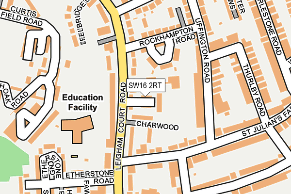
SW16 2RT lies on Chestnut Close in London. SW16 2RT is located in the Knight's Hill electoral ward, within the London borough of Lambeth and the English Parliamentary constituency of Dulwich and West Norwood. The Sub Integrated Care Board (ICB) Location is NHS South East London ICB - 72Q and the police force is Metropolitan Police. This postcode has been in use since July 1990.


GetTheData
Source: OS OpenMap – Local (Ordnance Survey)
Source: OS VectorMap District (Ordnance Survey)
Licence: Open Government Licence (requires attribution)
| Easting | 531233 |
| Northing | 171749 |
| Latitude | 51.429557 |
| Longitude | -0.113660 |
GetTheData
Source: Open Postcode Geo
Licence: Open Government Licence
| Street | Chestnut Close |
| Town/City | London |
| Country | England |
| Postcode District | SW16 |
➜ See where SW16 is on a map ➜ Where is London? | |
GetTheData
Source: Land Registry Price Paid Data
Licence: Open Government Licence
Elevation or altitude of SW16 2RT as distance above sea level:
| Metres | Feet | |
|---|---|---|
| Elevation | 80m | 262ft |
Elevation is measured from the approximate centre of the postcode, to the nearest point on an OS contour line from OS Terrain 50, which has contour spacing of ten vertical metres.
➜ How high above sea level am I? Find the elevation of your current position using your device's GPS.
GetTheData
Source: Open Postcode Elevation
Licence: Open Government Licence
| Ward | Knight's Hill |
| Constituency | Dulwich And West Norwood |
GetTheData
Source: ONS Postcode Database
Licence: Open Government Licence
| Julians Primary School | West Norwood | 86m |
| Rockhampton Road | West Norwood | 127m |
| Julians Primary School | West Norwood | 214m |
| St Peters Church (Sw16) | West Norwood | 225m |
| Canterbury Grove | West Norwood | 300m |
| West Norwood Station | 0.7km |
| Tulse Hill Station | 1.3km |
| Streatham Station | 1.3km |
GetTheData
Source: NaPTAN
Licence: Open Government Licence
| Percentage of properties with Next Generation Access | 0.0% |
| Percentage of properties with Superfast Broadband | 0.0% |
| Percentage of properties with Ultrafast Broadband | 0.0% |
| Percentage of properties with Full Fibre Broadband | 0.0% |
Superfast Broadband is between 30Mbps and 300Mbps
Ultrafast Broadband is > 300Mbps
| Percentage of properties unable to receive 2Mbps | 0.0% |
| Percentage of properties unable to receive 5Mbps | 0.0% |
| Percentage of properties unable to receive 10Mbps | 0.0% |
| Percentage of properties unable to receive 30Mbps | 100.0% |
GetTheData
Source: Ofcom
Licence: Ofcom Terms of Use (requires attribution)
GetTheData
Source: ONS Postcode Database
Licence: Open Government Licence


➜ Get more ratings from the Food Standards Agency
GetTheData
Source: Food Standards Agency
Licence: FSA terms & conditions
| Last Collection | |||
|---|---|---|---|
| Location | Mon-Fri | Sat | Distance |
| Thurlby Road | 17:30 | 12:00 | 164m |
| 202 Casewick Road | 17:30 | 12:00 | 282m |
| St.julians Farm Road | 17:30 | 12:00 | 336m |
GetTheData
Source: Dracos
Licence: Creative Commons Attribution-ShareAlike
The below table lists the International Territorial Level (ITL) codes (formerly Nomenclature of Territorial Units for Statistics (NUTS) codes) and Local Administrative Units (LAU) codes for SW16 2RT:
| ITL 1 Code | Name |
|---|---|
| TLI | London |
| ITL 2 Code | Name |
| TLI4 | Inner London - East |
| ITL 3 Code | Name |
| TLI45 | Lambeth |
| LAU 1 Code | Name |
| E09000022 | Lambeth |
GetTheData
Source: ONS Postcode Directory
Licence: Open Government Licence
The below table lists the Census Output Area (OA), Lower Layer Super Output Area (LSOA), and Middle Layer Super Output Area (MSOA) for SW16 2RT:
| Code | Name | |
|---|---|---|
| OA | E00015572 | |
| LSOA | E01003083 | Lambeth 030A |
| MSOA | E02000647 | Lambeth 030 |
GetTheData
Source: ONS Postcode Directory
Licence: Open Government Licence
| SW16 2SG | Chestnut Close | 20m |
| SW16 2SH | Chestnut Close | 30m |
| SW16 2SB | Leigham Court Road | 40m |
| SE27 0NG | Rockhampton Close | 73m |
| SW16 2SA | Charwood | 82m |
| SW16 2RB | Leigham Court Road | 89m |
| SE27 0RW | Uffington Road | 104m |
| SW16 2RD | Leigham Court Road | 107m |
| SW16 2RE | Leigham Court Road | 130m |
| SE27 0RP | St Julians Farm Road | 134m |
GetTheData
Source: Open Postcode Geo; Land Registry Price Paid Data
Licence: Open Government Licence