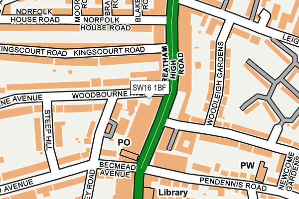
SW16 1BF lies on Woodbourne Avenue in London. SW16 1BF is located in the Streatham St Leonard's electoral ward, within the London borough of Lambeth and the English Parliamentary constituency of Streatham. The Sub Integrated Care Board (ICB) Location is NHS South East London ICB - 72Q and the police force is Metropolitan Police. This postcode has been in use since June 2009.


GetTheData
Source: OS OpenMap – Local (Ordnance Survey)
Source: OS VectorMap District (Ordnance Survey)
Licence: Open Government Licence (requires attribution)
| Easting | 530159 |
| Northing | 172142 |
| Latitude | 51.433337 |
| Longitude | -0.128956 |
GetTheData
Source: Open Postcode Geo
Licence: Open Government Licence
| Street | Woodbourne Avenue |
| Town/City | London |
| Country | England |
| Postcode District | SW16 |
➜ See where SW16 is on a map ➜ Where is Streatham? | |
GetTheData
Source: Land Registry Price Paid Data
Licence: Open Government Licence
Elevation or altitude of SW16 1BF as distance above sea level:
| Metres | Feet | |
|---|---|---|
| Elevation | 50m | 164ft |
Elevation is measured from the approximate centre of the postcode, to the nearest point on an OS contour line from OS Terrain 50, which has contour spacing of ten vertical metres.
➜ How high above sea level am I? Find the elevation of your current position using your device's GPS.
GetTheData
Source: Open Postcode Elevation
Licence: Open Government Licence
| Ward | Streatham St Leonard's |
| Constituency | Streatham |
GetTheData
Source: ONS Postcode Database
Licence: Open Government Licence
| Becmead Avenue (Streatham High Road) | Streatham | 60m |
| Becmead Avenue (Streatham High Road) | Streatham | 80m |
| Becmead Avenue (Streatham High Road) | Streatham | 91m |
| Becmead Avenue (Streatham High Road) | Streatham | 111m |
| Kingscourt Road (Streatham High Road) | Streatham | 131m |
| Streatham Hill Station | 0.6km |
| Streatham Station | 0.9km |
| Streatham Common Station | 1.7km |
GetTheData
Source: NaPTAN
Licence: Open Government Licence
| Percentage of properties with Next Generation Access | 100.0% |
| Percentage of properties with Superfast Broadband | 100.0% |
| Percentage of properties with Ultrafast Broadband | 100.0% |
| Percentage of properties with Full Fibre Broadband | 0.0% |
Superfast Broadband is between 30Mbps and 300Mbps
Ultrafast Broadband is > 300Mbps
| Percentage of properties unable to receive 2Mbps | 0.0% |
| Percentage of properties unable to receive 5Mbps | 0.0% |
| Percentage of properties unable to receive 10Mbps | 0.0% |
| Percentage of properties unable to receive 30Mbps | 0.0% |
GetTheData
Source: Ofcom
Licence: Ofcom Terms of Use (requires attribution)
GetTheData
Source: ONS Postcode Database
Licence: Open Government Licence


➜ Get more ratings from the Food Standards Agency
GetTheData
Source: Food Standards Agency
Licence: FSA terms & conditions
| Last Collection | |||
|---|---|---|---|
| Location | Mon-Fri | Sat | Distance |
| Post Office | 17:30 | 12:00 | 50m |
| 180-182 Streatham High Road | 17:15 | 12:00 | 109m |
| 180-182 Streatham High Road | 17:15 | 12:00 | 114m |
GetTheData
Source: Dracos
Licence: Creative Commons Attribution-ShareAlike
The below table lists the International Territorial Level (ITL) codes (formerly Nomenclature of Territorial Units for Statistics (NUTS) codes) and Local Administrative Units (LAU) codes for SW16 1BF:
| ITL 1 Code | Name |
|---|---|
| TLI | London |
| ITL 2 Code | Name |
| TLI4 | Inner London - East |
| ITL 3 Code | Name |
| TLI45 | Lambeth |
| LAU 1 Code | Name |
| E09000022 | Lambeth |
GetTheData
Source: ONS Postcode Directory
Licence: Open Government Licence
The below table lists the Census Output Area (OA), Lower Layer Super Output Area (LSOA), and Middle Layer Super Output Area (MSOA) for SW16 1BF:
| Code | Name | |
|---|---|---|
| OA | E00015745 | |
| LSOA | E01003118 | Lambeth 029C |
| MSOA | E02000646 | Lambeth 029 |
GetTheData
Source: ONS Postcode Directory
Licence: Open Government Licence
| SW16 1BP | Woodbourne Avenue | 8m |
| SW16 1UR | Woodbourne Close | 56m |
| SW16 1BJ | Streatham High Road | 84m |
| SW16 1PS | Streatham High Road | 84m |
| SW16 2TA | Gracefield Gardens | 85m |
| SW16 1BW | Streatham High Road | 93m |
| SW16 2SZ | Gracefield Gardens | 96m |
| SW16 1UB | Ockley Road | 103m |
| SW16 1UP | Woodbourne Avenue | 107m |
| SW16 2SY | Woodleigh Gardens | 131m |
GetTheData
Source: Open Postcode Geo; Land Registry Price Paid Data
Licence: Open Government Licence