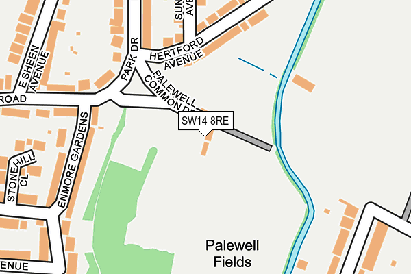
SW14 8RE lies on Palewell Common Drive in London. SW14 8RE is located in the East Sheen electoral ward, within the London borough of Richmond upon Thames and the English Parliamentary constituency of Richmond Park. The Sub Integrated Care Board (ICB) Location is NHS South West London ICB - 36L and the police force is Metropolitan Police. This postcode has been in use since January 1980.


GetTheData
Source: OS OpenMap – Local (Ordnance Survey)
Source: OS VectorMap District (Ordnance Survey)
Licence: Open Government Licence (requires attribution)
| Easting | 520996 |
| Northing | 174837 |
| Latitude | 51.459587 |
| Longitude | -0.259784 |
GetTheData
Source: Open Postcode Geo
Licence: Open Government Licence
| Street | Palewell Common Drive |
| Town/City | London |
| Country | England |
| Postcode District | SW14 |
➜ See where SW14 is on a map ➜ Where is London? | |
GetTheData
Source: Land Registry Price Paid Data
Licence: Open Government Licence
Elevation or altitude of SW14 8RE as distance above sea level:
| Metres | Feet | |
|---|---|---|
| Elevation | 10m | 33ft |
Elevation is measured from the approximate centre of the postcode, to the nearest point on an OS contour line from OS Terrain 50, which has contour spacing of ten vertical metres.
➜ How high above sea level am I? Find the elevation of your current position using your device's GPS.
GetTheData
Source: Open Postcode Elevation
Licence: Open Government Licence
| Ward | East Sheen |
| Constituency | Richmond Park |
GetTheData
Source: ONS Postcode Database
Licence: Open Government Licence
| Kings Road (Sw14) | East Sheen | 613m |
| Kings Road (Sw14) (Upper Richmond Road West) | East Sheen | 633m |
| Thornton Road Palewell Park (Upper Richmond Road West) | East Sheen | 659m |
| Richmond Park Road | East Sheen | 702m |
| Priests Bridge (Upper Richmond Road West) | East Sheen | 730m |
| Mortlake Station | 1.1km |
| Barnes Bridge Station | 1.5km |
| Barnes Station | 1.5km |
GetTheData
Source: NaPTAN
Licence: Open Government Licence
GetTheData
Source: ONS Postcode Database
Licence: Open Government Licence


➜ Get more ratings from the Food Standards Agency
GetTheData
Source: Food Standards Agency
Licence: FSA terms & conditions
| Last Collection | |||
|---|---|---|---|
| Location | Mon-Fri | Sat | Distance |
| Hertford Avenue | 17:30 | 12:00 | 144m |
| East Sheen Avenue | 17:30 | 12:00 | 284m |
| Palewell Park | 17:30 | 12:00 | 462m |
GetTheData
Source: Dracos
Licence: Creative Commons Attribution-ShareAlike
The below table lists the International Territorial Level (ITL) codes (formerly Nomenclature of Territorial Units for Statistics (NUTS) codes) and Local Administrative Units (LAU) codes for SW14 8RE:
| ITL 1 Code | Name |
|---|---|
| TLI | London |
| ITL 2 Code | Name |
| TLI7 | Outer London - West and North West |
| ITL 3 Code | Name |
| TLI75 | Hounslow and Richmond upon Thames |
| LAU 1 Code | Name |
| E09000027 | Richmond upon Thames |
GetTheData
Source: ONS Postcode Directory
Licence: Open Government Licence
The below table lists the Census Output Area (OA), Lower Layer Super Output Area (LSOA), and Middle Layer Super Output Area (MSOA) for SW14 8RE:
| Code | Name | |
|---|---|---|
| OA | E00019124 | |
| LSOA | E01003809 | Richmond upon Thames 005D |
| MSOA | E02000788 | Richmond upon Thames 005 |
GetTheData
Source: ONS Postcode Directory
Licence: Open Government Licence
| SW14 8EH | Hertford Avenue | 150m |
| SW14 8EQ | Hertford Avenue | 177m |
| SW14 8RF | Enmore Gardens | 189m |
| SW14 8RY | Vicarage Road | 209m |
| SW14 8RD | Park Drive | 234m |
| SW14 8RA | Sunbury Avenue | 242m |
| SW14 8RB | Park Drive | 246m |
| SW14 8RP | Stonehill Close | 273m |
| SW14 8AX | East Sheen Avenue | 278m |
| SW14 8RU | Vicarage Road | 310m |
GetTheData
Source: Open Postcode Geo; Land Registry Price Paid Data
Licence: Open Government Licence