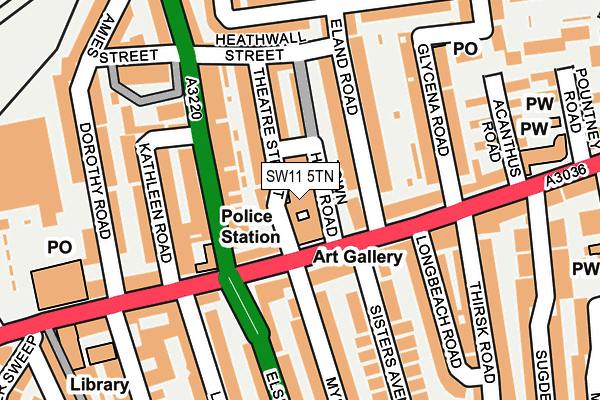
SW11 5TN is located in the Shaftesbury & Queenstown electoral ward, within the London borough of Wandsworth and the English Parliamentary constituency of Battersea. The Sub Integrated Care Board (ICB) Location is NHS South West London ICB - 36L and the police force is Metropolitan Police. This postcode has been in use since August 1992.


GetTheData
Source: OS OpenMap – Local (Ordnance Survey)
Source: OS VectorMap District (Ordnance Survey)
Licence: Open Government Licence (requires attribution)
| Easting | 527854 |
| Northing | 175625 |
| Latitude | 51.465162 |
| Longitude | -0.160839 |
GetTheData
Source: Open Postcode Geo
Licence: Open Government Licence
| Country | England |
| Postcode District | SW11 |
➜ See where SW11 is on a map ➜ Where is London? | |
GetTheData
Source: Land Registry Price Paid Data
Licence: Open Government Licence
Elevation or altitude of SW11 5TN as distance above sea level:
| Metres | Feet | |
|---|---|---|
| Elevation | 10m | 33ft |
Elevation is measured from the approximate centre of the postcode, to the nearest point on an OS contour line from OS Terrain 50, which has contour spacing of ten vertical metres.
➜ How high above sea level am I? Find the elevation of your current position using your device's GPS.
GetTheData
Source: Open Postcode Elevation
Licence: Open Government Licence
| Ward | Shaftesbury & Queenstown |
| Constituency | Battersea |
GetTheData
Source: ONS Postcode Database
Licence: Open Government Licence
| Battersea Arts Centre | Clapham Junction | 69m |
| Battersea Arts Centre | Clapham Junction | 102m |
| Lavender Hill Police Station | Clapham Junction | 186m |
| Lavender Hill Police Station | Clapham Junction | 281m |
| Tipthorpe Road | Clapham Junction | 311m |
| Clapham South Underground Station | Clapham South | 1,669m |
| Clapham Junction Station | 0.7km |
| Queenstown Road (Battersea) Station | 1.5km |
| Battersea Park Station | 1.6km |
GetTheData
Source: NaPTAN
Licence: Open Government Licence
GetTheData
Source: ONS Postcode Database
Licence: Open Government Licence


➜ Get more ratings from the Food Standards Agency
GetTheData
Source: Food Standards Agency
Licence: FSA terms & conditions
| Last Collection | |||
|---|---|---|---|
| Location | Mon-Fri | Sat | Distance |
| 185 Lavender Hill | 17:30 | 12:00 | 51m |
| Tyneham Road | 17:30 | 12:00 | 60m |
| 56 Glycena Road | 17:30 | 12:00 | 198m |
GetTheData
Source: Dracos
Licence: Creative Commons Attribution-ShareAlike
The below table lists the International Territorial Level (ITL) codes (formerly Nomenclature of Territorial Units for Statistics (NUTS) codes) and Local Administrative Units (LAU) codes for SW11 5TN:
| ITL 1 Code | Name |
|---|---|
| TLI | London |
| ITL 2 Code | Name |
| TLI3 | Inner London - West |
| ITL 3 Code | Name |
| TLI34 | Wandsworth |
| LAU 1 Code | Name |
| E09000032 | Wandsworth |
GetTheData
Source: ONS Postcode Directory
Licence: Open Government Licence
The below table lists the Census Output Area (OA), Lower Layer Super Output Area (LSOA), and Middle Layer Super Output Area (MSOA) for SW11 5TN:
| Code | Name | |
|---|---|---|
| OA | E00023126 | |
| LSOA | E01004585 | Wandsworth 008D |
| MSOA | E02000930 | Wandsworth 008 |
GetTheData
Source: ONS Postcode Directory
Licence: Open Government Licence
| SW11 5ND | Theatre Street | 43m |
| SW11 5TF | Lavender Hill | 56m |
| SW11 2LA | Latchmere Road | 61m |
| SW11 5TG | Lavender Hill | 71m |
| SW11 5TB | Lavender Hill | 84m |
| SW11 5JX | Eland Road | 85m |
| SW11 5SD | Lavender Hill | 93m |
| SW11 5NQ | Town Hall Road | 95m |
| SW11 5NF | Theatre Street | 98m |
| SW11 5TE | Lavender Hill | 102m |
GetTheData
Source: Open Postcode Geo; Land Registry Price Paid Data
Licence: Open Government Licence