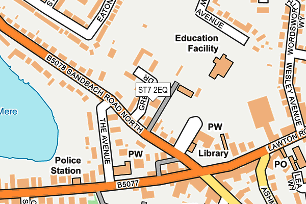
ST7 2EQ lies on Green Drive in Alsager, Stoke-on-trent. ST7 2EQ is located in the Alsager electoral ward, within the unitary authority of Cheshire East and the English Parliamentary constituency of Congleton. The Sub Integrated Care Board (ICB) Location is NHS Cheshire and Merseyside ICB - 27D and the police force is Cheshire. This postcode has been in use since January 1980.


GetTheData
Source: OS OpenMap – Local (Ordnance Survey)
Source: OS VectorMap District (Ordnance Survey)
Licence: Open Government Licence (requires attribution)
| Easting | 379602 |
| Northing | 355607 |
| Latitude | 53.097288 |
| Longitude | -2.306076 |
GetTheData
Source: Open Postcode Geo
Licence: Open Government Licence
| Street | Green Drive |
| Locality | Alsager |
| Town/City | Stoke-on-trent |
| Country | England |
| Postcode District | ST7 |
➜ See where ST7 is on a map ➜ Where is Alsager? | |
GetTheData
Source: Land Registry Price Paid Data
Licence: Open Government Licence
Elevation or altitude of ST7 2EQ as distance above sea level:
| Metres | Feet | |
|---|---|---|
| Elevation | 90m | 295ft |
Elevation is measured from the approximate centre of the postcode, to the nearest point on an OS contour line from OS Terrain 50, which has contour spacing of ten vertical metres.
➜ How high above sea level am I? Find the elevation of your current position using your device's GPS.
GetTheData
Source: Open Postcode Elevation
Licence: Open Government Licence
| Ward | Alsager |
| Constituency | Congleton |
GetTheData
Source: ONS Postcode Database
Licence: Open Government Licence
THE MEWS, GREEN DRIVE, ALSAGER, STOKE-ON-TRENT, ST7 2EQ 2008 9 MAY £345,000 |
GetTheData
Source: HM Land Registry Price Paid Data
Licence: Contains HM Land Registry data © Crown copyright and database right 2025. This data is licensed under the Open Government Licence v3.0.
| Bank Corner (Lawton Road) | Alsager | 163m |
| St Mary's Church (Crewe Road) | Alsager | 188m |
| Bank Corner (Lawton Road) | Alsager | 209m |
| Police Station (Crewe Road) | Alsager | 222m |
| Eaton Road | Alsager | 346m |
| Alsager Station | 0.7km |
| Kidsgrove Station | 4.3km |
GetTheData
Source: NaPTAN
Licence: Open Government Licence
| Percentage of properties with Next Generation Access | 100.0% |
| Percentage of properties with Superfast Broadband | 100.0% |
| Percentage of properties with Ultrafast Broadband | 0.0% |
| Percentage of properties with Full Fibre Broadband | 0.0% |
Superfast Broadband is between 30Mbps and 300Mbps
Ultrafast Broadband is > 300Mbps
| Percentage of properties unable to receive 2Mbps | 0.0% |
| Percentage of properties unable to receive 5Mbps | 0.0% |
| Percentage of properties unable to receive 10Mbps | 0.0% |
| Percentage of properties unable to receive 30Mbps | 0.0% |
GetTheData
Source: Ofcom
Licence: Ofcom Terms of Use (requires attribution)
GetTheData
Source: ONS Postcode Database
Licence: Open Government Licence


➜ Get more ratings from the Food Standards Agency
GetTheData
Source: Food Standards Agency
Licence: FSA terms & conditions
| Last Collection | |||
|---|---|---|---|
| Location | Mon-Fri | Sat | Distance |
| Crewe Road | 16:30 | 10:30 | 350m |
| The Pet Shop | 17:15 | 10:30 | 514m |
| Alsager Post Office | 17:30 | 11:30 | 942m |
GetTheData
Source: Dracos
Licence: Creative Commons Attribution-ShareAlike
The below table lists the International Territorial Level (ITL) codes (formerly Nomenclature of Territorial Units for Statistics (NUTS) codes) and Local Administrative Units (LAU) codes for ST7 2EQ:
| ITL 1 Code | Name |
|---|---|
| TLD | North West (England) |
| ITL 2 Code | Name |
| TLD6 | Cheshire |
| ITL 3 Code | Name |
| TLD62 | Cheshire East |
| LAU 1 Code | Name |
| E06000049 | Cheshire East |
GetTheData
Source: ONS Postcode Directory
Licence: Open Government Licence
The below table lists the Census Output Area (OA), Lower Layer Super Output Area (LSOA), and Middle Layer Super Output Area (MSOA) for ST7 2EQ:
| Code | Name | |
|---|---|---|
| OA | E00092769 | |
| LSOA | E01018389 | Cheshire East 040C |
| MSOA | E02003823 | Cheshire East 040 |
GetTheData
Source: ONS Postcode Directory
Licence: Open Government Licence
| ST7 2AQ | Sandbach Road North | 36m |
| ST7 2AG | Sandbach Road North | 90m |
| ST7 2AN | The Avenue | 104m |
| ST7 2AH | Lynton Place | 105m |
| ST7 2EW | Crewe Road | 136m |
| ST7 2ES | Crewe Road | 164m |
| ST7 2AP | Sandbach Road North | 183m |
| ST7 2NW | Fairview Avenue | 221m |
| ST7 2BQ | Eaton Road | 228m |
| ST7 2EY | Crewe Road | 233m |
GetTheData
Source: Open Postcode Geo; Land Registry Price Paid Data
Licence: Open Government Licence