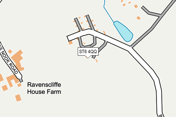
ST6 4QQ lies on Linehouses in Stoke-on-trent. ST6 4QQ is located in the Goldenhill & Sandyford electoral ward, within the unitary authority of Stoke-on-Trent and the English Parliamentary constituency of Stoke-on-Trent North. The Sub Integrated Care Board (ICB) Location is NHS Staffordshire and Stoke-on-Trent ICB - 05W and the police force is Staffordshire. This postcode has been in use since January 1980.


GetTheData
Source: OS OpenMap – Local (Ordnance Survey)
Source: OS VectorMap District (Ordnance Survey)
Licence: Open Government Licence (requires attribution)
| Easting | 384443 |
| Northing | 352576 |
| Latitude | 53.070190 |
| Longitude | -2.233634 |
GetTheData
Source: Open Postcode Geo
Licence: Open Government Licence
| Street | Linehouses |
| Town/City | Stoke-on-trent |
| Country | England |
| Postcode District | ST6 |
➜ See where ST6 is on a map | |
GetTheData
Source: Land Registry Price Paid Data
Licence: Open Government Licence
Elevation or altitude of ST6 4QQ as distance above sea level:
| Metres | Feet | |
|---|---|---|
| Elevation | 170m | 558ft |
Elevation is measured from the approximate centre of the postcode, to the nearest point on an OS contour line from OS Terrain 50, which has contour spacing of ten vertical metres.
➜ How high above sea level am I? Find the elevation of your current position using your device's GPS.
GetTheData
Source: Open Postcode Elevation
Licence: Open Government Licence
| Ward | Goldenhill & Sandyford |
| Constituency | Stoke-on-trent North |
GetTheData
Source: ONS Postcode Database
Licence: Open Government Licence
| Woodstock Road | Latebrook | 591m |
| Woodstock Road | Latebrook | 594m |
| Peckforton View (Chatterley Drive) | Kidsgrove | 868m |
| Peckforton View (Chatterley Dr) | Kidsgrove | 874m |
| Broadfield Road | Goldenhill | 878m |
| Kidsgrove Station | 2km |
| Longport Station | 3.4km |
| Alsager Station | 5.1km |
GetTheData
Source: NaPTAN
Licence: Open Government Licence
| Percentage of properties with Next Generation Access | 100.0% |
| Percentage of properties with Superfast Broadband | 0.0% |
| Percentage of properties with Ultrafast Broadband | 0.0% |
| Percentage of properties with Full Fibre Broadband | 0.0% |
Superfast Broadband is between 30Mbps and 300Mbps
Ultrafast Broadband is > 300Mbps
| Percentage of properties unable to receive 2Mbps | 0.0% |
| Percentage of properties unable to receive 5Mbps | 0.0% |
| Percentage of properties unable to receive 10Mbps | 0.0% |
| Percentage of properties unable to receive 30Mbps | 100.0% |
GetTheData
Source: Ofcom
Licence: Ofcom Terms of Use (requires attribution)
GetTheData
Source: ONS Postcode Database
Licence: Open Government Licence


➜ Get more ratings from the Food Standards Agency
GetTheData
Source: Food Standards Agency
Licence: FSA terms & conditions
| Last Collection | |||
|---|---|---|---|
| Location | Mon-Fri | Sat | Distance |
| Broadfield Road | 17:30 | 10:00 | 1,152m |
| Tower Square | 18:00 | 1,997m | |
| Tower Square | 18:00 | 12:15 | 1,999m |
GetTheData
Source: Dracos
Licence: Creative Commons Attribution-ShareAlike
The below table lists the International Territorial Level (ITL) codes (formerly Nomenclature of Territorial Units for Statistics (NUTS) codes) and Local Administrative Units (LAU) codes for ST6 4QQ:
| ITL 1 Code | Name |
|---|---|
| TLG | West Midlands (England) |
| ITL 2 Code | Name |
| TLG2 | Shropshire and Staffordshire |
| ITL 3 Code | Name |
| TLG23 | Stoke-on-Trent |
| LAU 1 Code | Name |
| E06000021 | Stoke-on-Trent |
GetTheData
Source: ONS Postcode Directory
Licence: Open Government Licence
The below table lists the Census Output Area (OA), Lower Layer Super Output Area (LSOA), and Middle Layer Super Output Area (MSOA) for ST6 4QQ:
| Code | Name | |
|---|---|---|
| OA | E00072496 | |
| LSOA | E01014358 | Stoke-on-Trent 002B |
| MSOA | E02002952 | Stoke-on-Trent 002 |
GetTheData
Source: ONS Postcode Directory
Licence: Open Government Licence
| ST6 4QF | Aubrey Street | 644m |
| ST6 4QL | Acres Nook | 705m |
| ST6 4QN | Woodstock Road | 716m |
| ST6 4QB | Hollywall Lane | 722m |
| ST6 4QA | Boathorse Road | 726m |
| ST6 4QP | Nelson Bank | 739m |
| ST6 4QE | Broadfield Road | 771m |
| ST7 4TB | Beeston View | 774m |
| ST6 4QD | Birchall Avenue | 841m |
| ST6 5QY | Edale Close | 842m |
GetTheData
Source: Open Postcode Geo; Land Registry Price Paid Data
Licence: Open Government Licence