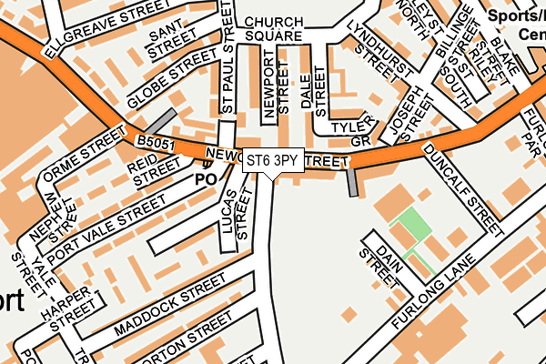
ST6 3PY is located in the Burslem electoral ward, within the unitary authority of Stoke-on-Trent and the English Parliamentary constituency of Stoke-on-Trent North. The Sub Integrated Care Board (ICB) Location is NHS Staffordshire and Stoke-on-Trent ICB - 05W and the police force is Staffordshire. This postcode has been in use since July 1990.


GetTheData
Source: OS OpenMap – Local (Ordnance Survey)
Source: OS VectorMap District (Ordnance Survey)
Licence: Open Government Licence (requires attribution)
| Easting | 386305 |
| Northing | 349555 |
| Latitude | 53.043086 |
| Longitude | -2.205715 |
GetTheData
Source: Open Postcode Geo
Licence: Open Government Licence
| Country | England |
| Postcode District | ST6 |
➜ See where ST6 is on a map ➜ Where is Stoke-on-Trent? | |
GetTheData
Source: Land Registry Price Paid Data
Licence: Open Government Licence
Elevation or altitude of ST6 3PY as distance above sea level:
| Metres | Feet | |
|---|---|---|
| Elevation | 130m | 427ft |
Elevation is measured from the approximate centre of the postcode, to the nearest point on an OS contour line from OS Terrain 50, which has contour spacing of ten vertical metres.
➜ How high above sea level am I? Find the elevation of your current position using your device's GPS.
GetTheData
Source: Open Postcode Elevation
Licence: Open Government Licence
| Ward | Burslem |
| Constituency | Stoke-on-trent North |
GetTheData
Source: ONS Postcode Database
Licence: Open Government Licence
| Newport Lane | Middleport | 40m |
| Dale Street (Newcastle Street) | Middleport | 75m |
| Reid Street (Newcastle Street) | Middleport | 114m |
| Maddock Street | Middleport | 172m |
| Furlong Lane | Middleport | 208m |
| Longport Station | 0.7km |
| Stoke-on-Trent Station | 4.2km |
| Kidsgrove Station | 5.5km |
GetTheData
Source: NaPTAN
Licence: Open Government Licence
| Percentage of properties with Next Generation Access | 100.0% |
| Percentage of properties with Superfast Broadband | 100.0% |
| Percentage of properties with Ultrafast Broadband | 0.0% |
| Percentage of properties with Full Fibre Broadband | 0.0% |
Superfast Broadband is between 30Mbps and 300Mbps
Ultrafast Broadband is > 300Mbps
| Percentage of properties unable to receive 2Mbps | 0.0% |
| Percentage of properties unable to receive 5Mbps | 0.0% |
| Percentage of properties unable to receive 10Mbps | 0.0% |
| Percentage of properties unable to receive 30Mbps | 0.0% |
GetTheData
Source: Ofcom
Licence: Ofcom Terms of Use (requires attribution)
GetTheData
Source: ONS Postcode Database
Licence: Open Government Licence


➜ Get more ratings from the Food Standards Agency
GetTheData
Source: Food Standards Agency
Licence: FSA terms & conditions
| Last Collection | |||
|---|---|---|---|
| Location | Mon-Fri | Sat | Distance |
| Dale Hall Post Office | 18:30 | 09:15 | 20m |
| Station Street | 18:30 | 09:15 | 589m |
| Burslem Post Office | 18:15 | 12:15 | 615m |
GetTheData
Source: Dracos
Licence: Creative Commons Attribution-ShareAlike
The below table lists the International Territorial Level (ITL) codes (formerly Nomenclature of Territorial Units for Statistics (NUTS) codes) and Local Administrative Units (LAU) codes for ST6 3PY:
| ITL 1 Code | Name |
|---|---|
| TLG | West Midlands (England) |
| ITL 2 Code | Name |
| TLG2 | Shropshire and Staffordshire |
| ITL 3 Code | Name |
| TLG23 | Stoke-on-Trent |
| LAU 1 Code | Name |
| E06000021 | Stoke-on-Trent |
GetTheData
Source: ONS Postcode Directory
Licence: Open Government Licence
The below table lists the Census Output Area (OA), Lower Layer Super Output Area (LSOA), and Middle Layer Super Output Area (MSOA) for ST6 3PY:
| Code | Name | |
|---|---|---|
| OA | E00071984 | |
| LSOA | E01014250 | Stoke-on-Trent 009B |
| MSOA | E02002959 | Stoke-on-Trent 009 |
GetTheData
Source: ONS Postcode Directory
Licence: Open Government Licence
| ST6 3QJ | Newcastle Street | 35m |
| ST6 3QH | Newcastle Street | 43m |
| ST6 3PP | Newport Lane | 80m |
| ST6 4BX | Newport Street | 91m |
| ST6 4DP | Dale Street | 104m |
| ST6 4DR | Tyler Grove | 113m |
| ST6 4BU | Newport Street | 116m |
| ST6 3PJ | Newport Lane | 118m |
| ST6 3PG | Travers Street | 122m |
| ST6 3QW | Newcastle Street | 126m |
GetTheData
Source: Open Postcode Geo; Land Registry Price Paid Data
Licence: Open Government Licence