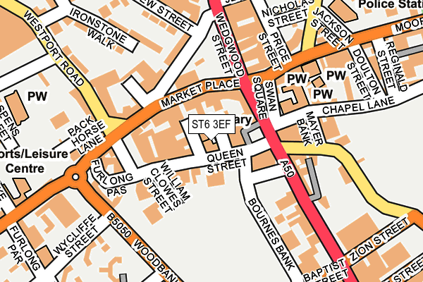
ST6 3EF is located in the Burslem electoral ward, within the unitary authority of Stoke-on-Trent and the English Parliamentary constituency of Stoke-on-Trent North. The Sub Integrated Care Board (ICB) Location is NHS Staffordshire and Stoke-on-Trent ICB - 05W and the police force is Staffordshire. This postcode has been in use since January 1980.


GetTheData
Source: OS OpenMap – Local (Ordnance Survey)
Source: OS VectorMap District (Ordnance Survey)
Licence: Open Government Licence (requires attribution)
| Easting | 386899 |
| Northing | 349762 |
| Latitude | 53.044979 |
| Longitude | -2.196864 |
GetTheData
Source: Open Postcode Geo
Licence: Open Government Licence
| Country | England |
| Postcode District | ST6 |
➜ See where ST6 is on a map ➜ Where is Stoke-on-Trent? | |
GetTheData
Source: Land Registry Price Paid Data
Licence: Open Government Licence
Elevation or altitude of ST6 3EF as distance above sea level:
| Metres | Feet | |
|---|---|---|
| Elevation | 150m | 492ft |
Elevation is measured from the approximate centre of the postcode, to the nearest point on an OS contour line from OS Terrain 50, which has contour spacing of ten vertical metres.
➜ How high above sea level am I? Find the elevation of your current position using your device's GPS.
GetTheData
Source: Open Postcode Elevation
Licence: Open Government Licence
| Ward | Burslem |
| Constituency | Stoke-on-trent North |
GetTheData
Source: ONS Postcode Database
Licence: Open Government Licence
| Swan Bank (Swan Square) | Burslem | 57m |
| Nilet Street (Waterloo Road) | Burslem | 61m |
| Town Hall (Market Place) | Burslem | 98m |
| Wedgwood Street | Burslem | 145m |
| Market Place | Burslem | 145m |
| Longport Station | 1.4km |
| Stoke-on-Trent Station | 4.2km |
| Kidsgrove Station | 5.6km |
GetTheData
Source: NaPTAN
Licence: Open Government Licence
GetTheData
Source: ONS Postcode Database
Licence: Open Government Licence


➜ Get more ratings from the Food Standards Agency
GetTheData
Source: Food Standards Agency
Licence: FSA terms & conditions
| Last Collection | |||
|---|---|---|---|
| Location | Mon-Fri | Sat | Distance |
| Burslem Post Office | 18:15 | 12:15 | 80m |
| Moorland Road | 17:30 | 11:00 | 478m |
| Scotia Road | 17:00 | 09:30 | 564m |
GetTheData
Source: Dracos
Licence: Creative Commons Attribution-ShareAlike
The below table lists the International Territorial Level (ITL) codes (formerly Nomenclature of Territorial Units for Statistics (NUTS) codes) and Local Administrative Units (LAU) codes for ST6 3EF:
| ITL 1 Code | Name |
|---|---|
| TLG | West Midlands (England) |
| ITL 2 Code | Name |
| TLG2 | Shropshire and Staffordshire |
| ITL 3 Code | Name |
| TLG23 | Stoke-on-Trent |
| LAU 1 Code | Name |
| E06000021 | Stoke-on-Trent |
GetTheData
Source: ONS Postcode Directory
Licence: Open Government Licence
The below table lists the Census Output Area (OA), Lower Layer Super Output Area (LSOA), and Middle Layer Super Output Area (MSOA) for ST6 3EF:
| Code | Name | |
|---|---|---|
| OA | E00071958 | |
| LSOA | E01014251 | Stoke-on-Trent 009C |
| MSOA | E02002959 | Stoke-on-Trent 009 |
GetTheData
Source: ONS Postcode Directory
Licence: Open Government Licence
| ST6 3EL | Queen Street | 39m |
| ST6 3AE | Brickhouse Street | 56m |
| ST6 3AA | Market Place | 59m |
| ST6 3EG | Queen Street | 96m |
| ST6 3AG | Market Place | 96m |
| ST6 3EH | Queen Street | 96m |
| ST6 2AF | Nile Street | 122m |
| ST6 2EH | Waterloo Road | 129m |
| ST6 1DW | Moorland Road | 133m |
| ST6 3AH | St Johns Square | 134m |
GetTheData
Source: Open Postcode Geo; Land Registry Price Paid Data
Licence: Open Government Licence