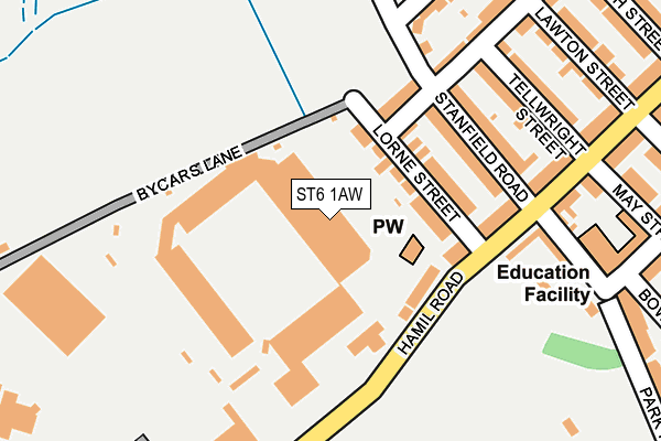
ST6 1AW is located in the Burslem Park electoral ward, within the unitary authority of Stoke-on-Trent and the English Parliamentary constituency of Stoke-on-Trent North. The Sub Integrated Care Board (ICB) Location is NHS Staffordshire and Stoke-on-Trent ICB - 05W and the police force is Staffordshire. This postcode has been in use since May 2017.


GetTheData
Source: OS OpenMap – Local (Ordnance Survey)
Source: OS VectorMap District (Ordnance Survey)
Licence: Open Government Licence (requires attribution)
| Easting | 387247 |
| Northing | 350365 |
| Latitude | 53.050408 |
| Longitude | -2.191697 |
GetTheData
Source: Open Postcode Geo
Licence: Open Government Licence
| Country | England |
| Postcode District | ST6 |
➜ See where ST6 is on a map ➜ Where is Stoke-on-Trent? | |
GetTheData
Source: Land Registry Price Paid Data
Licence: Open Government Licence
Elevation or altitude of ST6 1AW as distance above sea level:
| Metres | Feet | |
|---|---|---|
| Elevation | 160m | 525ft |
Elevation is measured from the approximate centre of the postcode, to the nearest point on an OS contour line from OS Terrain 50, which has contour spacing of ten vertical metres.
➜ How high above sea level am I? Find the elevation of your current position using your device's GPS.
GetTheData
Source: Open Postcode Elevation
Licence: Open Government Licence
| Ward | Burslem Park |
| Constituency | Stoke-on-trent North |
GetTheData
Source: ONS Postcode Database
Licence: Open Government Licence
| Burslem Greenway (Moorland Road) | Burslem | 421m |
| Burslem Greenway (Moorland Road) | Burslem | 433m |
| Federation Road (Scotia Road) | Burslem | 473m |
| Bycars Road (Scotia Road) | Burslem | 480m |
| Hamil Road (High Lane) | Burslem | 488m |
| Longport Station | 1.9km |
| Stoke-on-Trent Station | 4.8km |
| Kidsgrove Station | 5.4km |
GetTheData
Source: NaPTAN
Licence: Open Government Licence
GetTheData
Source: ONS Postcode Database
Licence: Open Government Licence


➜ Get more ratings from the Food Standards Agency
GetTheData
Source: Food Standards Agency
Licence: FSA terms & conditions
| Last Collection | |||
|---|---|---|---|
| Location | Mon-Fri | Sat | Distance |
| Hamil Road | 17:30 | 11:00 | 286m |
| Moorland Road | 17:30 | 09:30 | 400m |
| Moorland Road | 17:30 | 11:00 | 401m |
GetTheData
Source: Dracos
Licence: Creative Commons Attribution-ShareAlike
The below table lists the International Territorial Level (ITL) codes (formerly Nomenclature of Territorial Units for Statistics (NUTS) codes) and Local Administrative Units (LAU) codes for ST6 1AW:
| ITL 1 Code | Name |
|---|---|
| TLG | West Midlands (England) |
| ITL 2 Code | Name |
| TLG2 | Shropshire and Staffordshire |
| ITL 3 Code | Name |
| TLG23 | Stoke-on-Trent |
| LAU 1 Code | Name |
| E06000021 | Stoke-on-Trent |
GetTheData
Source: ONS Postcode Directory
Licence: Open Government Licence
The below table lists the Census Output Area (OA), Lower Layer Super Output Area (LSOA), and Middle Layer Super Output Area (MSOA) for ST6 1AW:
| Code | Name | |
|---|---|---|
| OA | E00071910 | |
| LSOA | E01014247 | Stoke-on-Trent 009A |
| MSOA | E02002959 | Stoke-on-Trent 009 |
GetTheData
Source: ONS Postcode Directory
Licence: Open Government Licence
| ST6 1AR | Lorne Street | 103m |
| ST6 1AT | Stanfield Road | 160m |
| ST6 1AP | Hamil Road | 165m |
| ST6 1AS | Louise Street | 188m |
| ST6 1AX | Tellwright Street | 200m |
| ST6 1AJ | Hamil Road | 224m |
| ST6 1BU | Dollys Lane | 232m |
| ST6 1AU | Hamil Road | 256m |
| ST6 1DB | Hamil Road | 257m |
| ST6 1AZ | Lawton Street | 260m |
GetTheData
Source: Open Postcode Geo; Land Registry Price Paid Data
Licence: Open Government Licence