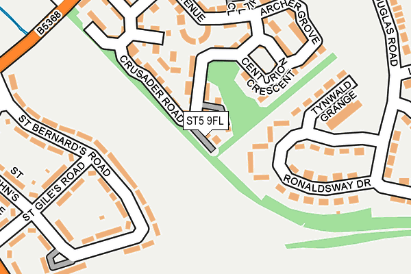
ST5 9FL is located in the Cross Heath electoral ward, within the local authority district of Newcastle-under-Lyme and the English Parliamentary constituency of Newcastle-under-Lyme. The Sub Integrated Care Board (ICB) Location is NHS Staffordshire and Stoke-on-Trent ICB - 05G and the police force is Staffordshire. This postcode has been in use since April 2016.


GetTheData
Source: OS OpenMap – Local (Ordnance Survey)
Source: OS VectorMap District (Ordnance Survey)
Licence: Open Government Licence (requires attribution)
| Easting | 383949 |
| Northing | 346900 |
| Latitude | 53.019171 |
| Longitude | -2.240722 |
GetTheData
Source: Open Postcode Geo
Licence: Open Government Licence
| Country | England |
| Postcode District | ST5 |
➜ See where ST5 is on a map ➜ Where is Newcastle-under-Lyme? | |
GetTheData
Source: Land Registry Price Paid Data
Licence: Open Government Licence
Elevation or altitude of ST5 9FL as distance above sea level:
| Metres | Feet | |
|---|---|---|
| Elevation | 130m | 427ft |
Elevation is measured from the approximate centre of the postcode, to the nearest point on an OS contour line from OS Terrain 50, which has contour spacing of ten vertical metres.
➜ How high above sea level am I? Find the elevation of your current position using your device's GPS.
GetTheData
Source: Open Postcode Elevation
Licence: Open Government Licence
| Ward | Cross Heath |
| Constituency | Newcastle-under-lyme |
GetTheData
Source: ONS Postcode Database
Licence: Open Government Licence
1, CROMWELL PLACE, NEWCASTLE, ST5 9FL 2016 24 MAR £169,995 |
➜ Newcastle-under-Lyme house prices
GetTheData
Source: HM Land Registry Price Paid Data
Licence: Contains HM Land Registry data © Crown copyright and database right 2025. This data is licensed under the Open Government Licence v3.0.
| Castletown Grange (Douglas Road) | Cross Heath | 269m |
| Castletown Grange (Douglas Rd) | Cross Heath | 269m |
| Weston Close (Lower Milehouse Ln) | Cross Heath | 278m |
| Weston Close (Lower Milehouse Ln) | Cross Heath | 287m |
| St Bernards Road (Lower Milehouse Lane) | Knutton | 318m |
| Longport Station | 3km |
| Stoke-on-Trent Station | 4.2km |
GetTheData
Source: NaPTAN
Licence: Open Government Licence
| Percentage of properties with Next Generation Access | 100.0% |
| Percentage of properties with Superfast Broadband | 100.0% |
| Percentage of properties with Ultrafast Broadband | 100.0% |
| Percentage of properties with Full Fibre Broadband | 0.0% |
Superfast Broadband is between 30Mbps and 300Mbps
Ultrafast Broadband is > 300Mbps
| Percentage of properties unable to receive 2Mbps | 0.0% |
| Percentage of properties unable to receive 5Mbps | 0.0% |
| Percentage of properties unable to receive 10Mbps | 0.0% |
| Percentage of properties unable to receive 30Mbps | 0.0% |
GetTheData
Source: Ofcom
Licence: Ofcom Terms of Use (requires attribution)
GetTheData
Source: ONS Postcode Database
Licence: Open Government Licence


➜ Get more ratings from the Food Standards Agency
GetTheData
Source: Food Standards Agency
Licence: FSA terms & conditions
| Last Collection | |||
|---|---|---|---|
| Location | Mon-Fri | Sat | Distance |
| Newcastle Post Office | 17:30 | 12:30 | 1,168m |
| Sidmouth Avenue | 17:30 | 11:45 | 1,261m |
| Thistleberry Avenue | 18:00 | 11:00 | 1,278m |
GetTheData
Source: Dracos
Licence: Creative Commons Attribution-ShareAlike
The below table lists the International Territorial Level (ITL) codes (formerly Nomenclature of Territorial Units for Statistics (NUTS) codes) and Local Administrative Units (LAU) codes for ST5 9FL:
| ITL 1 Code | Name |
|---|---|
| TLG | West Midlands (England) |
| ITL 2 Code | Name |
| TLG2 | Shropshire and Staffordshire |
| ITL 3 Code | Name |
| TLG24 | Staffordshire CC |
| LAU 1 Code | Name |
| E07000195 | Newcastle-under-Lyme |
GetTheData
Source: ONS Postcode Directory
Licence: Open Government Licence
The below table lists the Census Output Area (OA), Lower Layer Super Output Area (LSOA), and Middle Layer Super Output Area (MSOA) for ST5 9FL:
| Code | Name | |
|---|---|---|
| OA | E00150580 | |
| LSOA | E01029554 | Newcastle-under-Lyme 010B |
| MSOA | E02006167 | Newcastle-under-Lyme 010 |
GetTheData
Source: ONS Postcode Directory
Licence: Open Government Licence
| ST5 6HJ | St Bernards Road | 131m |
| ST5 9FB | Comet Avenue | 139m |
| ST5 9HE | Ronaldsway Drive | 139m |
| ST5 9FG | Centurion Crescent | 143m |
| ST5 9FH | Matilda Grove | 144m |
| ST5 9DU | Tynwald Grange | 171m |
| ST5 9FE | Archer Grove | 200m |
| ST5 9FD | Crusader Road | 207m |
| ST5 9FF | Churchill Close | 224m |
| ST5 6HH | St Bernards Road | 232m |
GetTheData
Source: Open Postcode Geo; Land Registry Price Paid Data
Licence: Open Government Licence