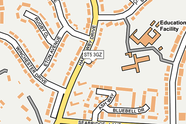
ST5 3GZ lies on Harrowby Drive in Newcastle. ST5 3GZ is located in the Westlands electoral ward, within the local authority district of Newcastle-under-Lyme and the English Parliamentary constituency of Newcastle-under-Lyme. The Sub Integrated Care Board (ICB) Location is NHS Staffordshire and Stoke-on-Trent ICB - 05G and the police force is Staffordshire. This postcode has been in use since October 2007.


GetTheData
Source: OS OpenMap – Local (Ordnance Survey)
Source: OS VectorMap District (Ordnance Survey)
Licence: Open Government Licence (requires attribution)
| Easting | 383979 |
| Northing | 343874 |
| Latitude | 52.991954 |
| Longitude | -2.240123 |
GetTheData
Source: Open Postcode Geo
Licence: Open Government Licence
| Street | Harrowby Drive |
| Town/City | Newcastle |
| Country | England |
| Postcode District | ST5 |
➜ See where ST5 is on a map ➜ Where is Newcastle-under-Lyme? | |
GetTheData
Source: Land Registry Price Paid Data
Licence: Open Government Licence
Elevation or altitude of ST5 3GZ as distance above sea level:
| Metres | Feet | |
|---|---|---|
| Elevation | 150m | 492ft |
Elevation is measured from the approximate centre of the postcode, to the nearest point on an OS contour line from OS Terrain 50, which has contour spacing of ten vertical metres.
➜ How high above sea level am I? Find the elevation of your current position using your device's GPS.
GetTheData
Source: Open Postcode Elevation
Licence: Open Government Licence
| Ward | Westlands |
| Constituency | Newcastle-under-lyme |
GetTheData
Source: ONS Postcode Database
Licence: Open Government Licence
4, HARROWBY COURT, HARROWBY DRIVE, NEWCASTLE, ST5 3GZ 2017 15 JUN £617,500 |
4, HARROWBY COURT, HARROWBY DRIVE, NEWCASTLE, ST5 3GZ 2010 25 JUN £499,995 |
1, HARROWBY COURT, HARROWBY DRIVE, NEWCASTLE, ST5 3GZ 2009 7 AUG £449,500 |
3, HARROWBY COURT, HARROWBY DRIVE, NEWCASTLE, ST5 3GZ 2009 6 FEB £399,995 |
2, HARROWBY COURT, NEWCASTLE, ST5 3GZ 2008 25 APR £475,000 |
4, HARROWBY COURT, HARROWBY DRIVE, NEWCASTLE, ST5 3GZ 2007 21 SEP £499,995 |
➜ Newcastle-under-Lyme house prices
GetTheData
Source: HM Land Registry Price Paid Data
Licence: Contains HM Land Registry data © Crown copyright and database right 2025. This data is licensed under the Open Government Licence v3.0.
| Repton Drive (Harrowby Drive) | Westlands | 113m |
| Stockwood Road (Ridgemont Rd) | Seabridge | 281m |
| Seabridge School (Roe Lane) | Westlands | 288m |
| Langford Road (Ridgemont Rd) | Seabridge | 292m |
| Ridgmont Road (Seabridge Lane) | Seabridge | 431m |
| Stoke-on-Trent Station | 4.4km |
| Wedgwood Station | 6.5km |
GetTheData
Source: NaPTAN
Licence: Open Government Licence
| Percentage of properties with Next Generation Access | 100.0% |
| Percentage of properties with Superfast Broadband | 100.0% |
| Percentage of properties with Ultrafast Broadband | 0.0% |
| Percentage of properties with Full Fibre Broadband | 0.0% |
Superfast Broadband is between 30Mbps and 300Mbps
Ultrafast Broadband is > 300Mbps
| Percentage of properties unable to receive 2Mbps | 0.0% |
| Percentage of properties unable to receive 5Mbps | 0.0% |
| Percentage of properties unable to receive 10Mbps | 0.0% |
| Percentage of properties unable to receive 30Mbps | 0.0% |
GetTheData
Source: Ofcom
Licence: Ofcom Terms of Use (requires attribution)
GetTheData
Source: ONS Postcode Database
Licence: Open Government Licence


➜ Get more ratings from the Food Standards Agency
GetTheData
Source: Food Standards Agency
Licence: FSA terms & conditions
| Last Collection | |||
|---|---|---|---|
| Location | Mon-Fri | Sat | Distance |
| Windermere Road Post Office | 17:00 | 11:45 | 971m |
| Earls Drive | 17:30 | 10:15 | 994m |
| 66 Paris Avenue | 17:30 | 11:30 | 1,250m |
GetTheData
Source: Dracos
Licence: Creative Commons Attribution-ShareAlike
The below table lists the International Territorial Level (ITL) codes (formerly Nomenclature of Territorial Units for Statistics (NUTS) codes) and Local Administrative Units (LAU) codes for ST5 3GZ:
| ITL 1 Code | Name |
|---|---|
| TLG | West Midlands (England) |
| ITL 2 Code | Name |
| TLG2 | Shropshire and Staffordshire |
| ITL 3 Code | Name |
| TLG24 | Staffordshire CC |
| LAU 1 Code | Name |
| E07000195 | Newcastle-under-Lyme |
GetTheData
Source: ONS Postcode Directory
Licence: Open Government Licence
The below table lists the Census Output Area (OA), Lower Layer Super Output Area (LSOA), and Middle Layer Super Output Area (MSOA) for ST5 3GZ:
| Code | Name | |
|---|---|---|
| OA | E00150867 | |
| LSOA | E01029608 | Newcastle-under-Lyme 015G |
| MSOA | E02006172 | Newcastle-under-Lyme 015 |
GetTheData
Source: ONS Postcode Directory
Licence: Open Government Licence
| ST5 3JW | Harrowby Drive | 59m |
| ST5 3JP | Harrowby Drive | 78m |
| ST5 3JR | Harrowby Drive | 112m |
| ST5 3JL | Eton Avenue | 120m |
| ST5 3UB | Ash Way | 120m |
| ST5 3JS | Harrowby Drive | 145m |
| ST5 3JD | Sherborne Drive | 180m |
| ST5 3JU | Harrowby Drive | 183m |
| ST5 3UD | Bluebell Drive | 193m |
| ST5 3JT | Harrowby Drive | 199m |
GetTheData
Source: Open Postcode Geo; Land Registry Price Paid Data
Licence: Open Government Licence