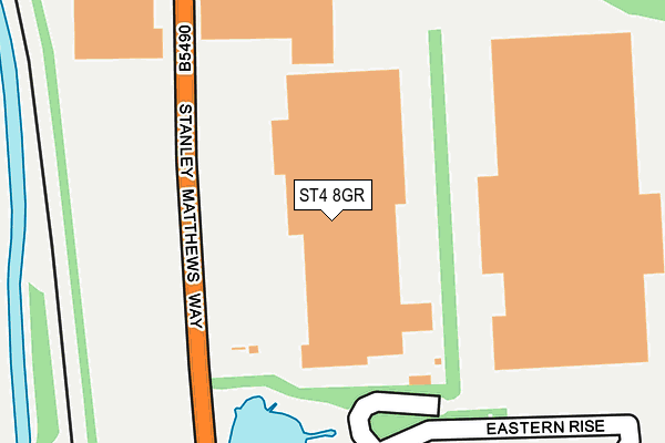
ST4 8GR is located in the Hollybush electoral ward, within the unitary authority of Stoke-on-Trent and the English Parliamentary constituency of Stoke-on-Trent South. The Sub Integrated Care Board (ICB) Location is NHS Staffordshire and Stoke-on-Trent ICB - 05W and the police force is Staffordshire. This postcode has been in use since December 2000.


GetTheData
Source: OS OpenMap – Local (Ordnance Survey)
Source: OS VectorMap District (Ordnance Survey)
Licence: Open Government Licence (requires attribution)
| Easting | 388305 |
| Northing | 342596 |
| Latitude | 52.980596 |
| Longitude | -2.175630 |
GetTheData
Source: Open Postcode Geo
Licence: Open Government Licence
| Country | England |
| Postcode District | ST4 |
➜ See where ST4 is on a map ➜ Where is Stoke-on-Trent? | |
GetTheData
Source: Land Registry Price Paid Data
Licence: Open Government Licence
Elevation or altitude of ST4 8GR as distance above sea level:
| Metres | Feet | |
|---|---|---|
| Elevation | 120m | 394ft |
Elevation is measured from the approximate centre of the postcode, to the nearest point on an OS contour line from OS Terrain 50, which has contour spacing of ten vertical metres.
➜ How high above sea level am I? Find the elevation of your current position using your device's GPS.
GetTheData
Source: Open Postcode Elevation
Licence: Open Government Licence
| Ward | Hollybush |
| Constituency | Stoke-on-trent South |
GetTheData
Source: ONS Postcode Database
Licence: Open Government Licence
| Pets At Home (Stanley Matthews Way) | Hem Heath | 154m |
| Latium Logistics (Stanley Matthews Way) | Hem Heath | 258m |
| Pets At Home (Stanley Matthews Way) | Hem Heath | 297m |
| Latium Logistics (Stanley Matthews Way) | Hem Heath | 360m |
| Dunelm Distribution Centre (Radial Park) | Sideway | 768m |
| Longton Station | 2.8km |
| Stoke-on-Trent Station | 3.1km |
| Wedgwood Station | 3.3km |
GetTheData
Source: NaPTAN
Licence: Open Government Licence
GetTheData
Source: ONS Postcode Database
Licence: Open Government Licence


➜ Get more ratings from the Food Standards Agency
GetTheData
Source: Food Standards Agency
Licence: FSA terms & conditions
| Last Collection | |||
|---|---|---|---|
| Location | Mon-Fri | Sat | Distance |
| Pacific Road | 17:30 | 09:30 | 1,059m |
| Cemlyn Avenue | 17:30 | 11:00 | 1,246m |
| Wilson Road | 17:45 | 09:15 | 1,316m |
GetTheData
Source: Dracos
Licence: Creative Commons Attribution-ShareAlike
The below table lists the International Territorial Level (ITL) codes (formerly Nomenclature of Territorial Units for Statistics (NUTS) codes) and Local Administrative Units (LAU) codes for ST4 8GR:
| ITL 1 Code | Name |
|---|---|
| TLG | West Midlands (England) |
| ITL 2 Code | Name |
| TLG2 | Shropshire and Staffordshire |
| ITL 3 Code | Name |
| TLG23 | Stoke-on-Trent |
| LAU 1 Code | Name |
| E06000021 | Stoke-on-Trent |
GetTheData
Source: ONS Postcode Directory
Licence: Open Government Licence
The below table lists the Census Output Area (OA), Lower Layer Super Output Area (LSOA), and Middle Layer Super Output Area (MSOA) for ST4 8GR:
| Code | Name | |
|---|---|---|
| OA | E00071875 | |
| LSOA | E01014234 | Stoke-on-Trent 026B |
| MSOA | E02002976 | Stoke-on-Trent 026 |
GetTheData
Source: ONS Postcode Directory
Licence: Open Government Licence
| ST4 8HS | Bengal Grove | 688m |
| ST3 2BJ | Laurel Grove | 692m |
| ST4 8UL | Aegean Close | 756m |
| ST3 2BH | Roundway | 776m |
| ST4 4EX | Sideway | 790m |
| ST3 2BQ | Meaford Drive | 795m |
| ST3 2BF | Park View Close | 814m |
| ST3 2BG | Meaford Drive | 816m |
| ST4 8UH | Biscay Grove | 821m |
| ST4 8XD | Stowford Grove | 865m |
GetTheData
Source: Open Postcode Geo; Land Registry Price Paid Data
Licence: Open Government Licence