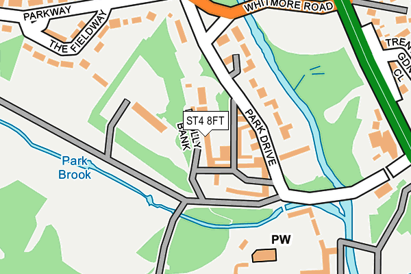
ST4 8FT lies on Holly Bank in Stoke-on-trent. ST4 8FT is located in the Swynnerton & Oulton electoral ward, within the local authority district of Stafford and the English Parliamentary constituency of Stone. The Sub Integrated Care Board (ICB) Location is NHS Staffordshire and Stoke-on-Trent ICB - 05V and the police force is Staffordshire. This postcode has been in use since June 1998.


GetTheData
Source: OS OpenMap – Local (Ordnance Survey)
Source: OS VectorMap District (Ordnance Survey)
Licence: Open Government Licence (requires attribution)
| Easting | 386451 |
| Northing | 341080 |
| Latitude | 52.966907 |
| Longitude | -2.203179 |
GetTheData
Source: Open Postcode Geo
Licence: Open Government Licence
| Street | Holly Bank |
| Town/City | Stoke-on-trent |
| Country | England |
| Postcode District | ST4 |
➜ See where ST4 is on a map ➜ Where is Stoke-on-Trent? | |
GetTheData
Source: Land Registry Price Paid Data
Licence: Open Government Licence
Elevation or altitude of ST4 8FT as distance above sea level:
| Metres | Feet | |
|---|---|---|
| Elevation | 100m | 328ft |
Elevation is measured from the approximate centre of the postcode, to the nearest point on an OS contour line from OS Terrain 50, which has contour spacing of ten vertical metres.
➜ How high above sea level am I? Find the elevation of your current position using your device's GPS.
GetTheData
Source: Open Postcode Elevation
Licence: Open Government Licence
| Ward | Swynnerton & Oulton |
| Constituency | Stone |
GetTheData
Source: ONS Postcode Database
Licence: Open Government Licence
GABLES END, HOLLY BANK, STOKE-ON-TRENT, ST4 8FT 2018 17 OCT £450,000 |
GABLES END, HOLLY BANK, STOKE-ON-TRENT, ST4 8FT 2000 27 JAN £205,000 |
HOLLY HOUSE, HOLLY BANK, STOKE-ON-TRENT, ST4 8FT 1998 10 JUL £210,000 |
HOLLY HOUSE, HOLLY BANK, STOKE-ON-TRENT, ST4 8FT 1997 7 NOV £65,000 |
GABLES END, HOLLY BANK, STOKE-ON-TRENT, ST4 8FT 1997 29 SEP £50,000 |
HOLLY HOUSE, HOLLY BANK, STOKE-ON-TRENT, ST4 8FT 1997 28 AUG £65,000 |
HILLTOP HOUSE, HOLLY BANK, STOKE-ON-TRENT, ST4 8FT 1997 28 AUG £135,000 |
GetTheData
Source: HM Land Registry Price Paid Data
Licence: Contains HM Land Registry data © Crown copyright and database right 2025. This data is licensed under the Open Government Licence v3.0.
| The Parkway (Whitmore Road) | Hanchurch | 257m |
| Poachers Cottage Ph (Trentham Gardens) | Trentham | 298m |
| Whitmore Road (Stone Road) | Trentham | 333m |
| Trentham Gardens (Stone Road) | Trentham | 400m |
| Allerton Road (Stone Road) | Trentham | 417m |
| Wedgwood Station | 2.8km |
| Barlaston Station | 3.6km |
| Stoke-on-Trent Station | 4.8km |
GetTheData
Source: NaPTAN
Licence: Open Government Licence
| Percentage of properties with Next Generation Access | 100.0% |
| Percentage of properties with Superfast Broadband | 100.0% |
| Percentage of properties with Ultrafast Broadband | 0.0% |
| Percentage of properties with Full Fibre Broadband | 0.0% |
Superfast Broadband is between 30Mbps and 300Mbps
Ultrafast Broadband is > 300Mbps
| Percentage of properties unable to receive 2Mbps | 0.0% |
| Percentage of properties unable to receive 5Mbps | 0.0% |
| Percentage of properties unable to receive 10Mbps | 0.0% |
| Percentage of properties unable to receive 30Mbps | 0.0% |
GetTheData
Source: Ofcom
Licence: Ofcom Terms of Use (requires attribution)
GetTheData
Source: ONS Postcode Database
Licence: Open Government Licence


➜ Get more ratings from the Food Standards Agency
GetTheData
Source: Food Standards Agency
Licence: FSA terms & conditions
| Last Collection | |||
|---|---|---|---|
| Location | Mon-Fri | Sat | Distance |
| Allerton Road | 17:30 | 11:00 | 320m |
| Dairyfields | 18:00 | 09:30 | 325m |
| Bankhouse Road | 17:00 | 09:15 | 737m |
GetTheData
Source: Dracos
Licence: Creative Commons Attribution-ShareAlike
The below table lists the International Territorial Level (ITL) codes (formerly Nomenclature of Territorial Units for Statistics (NUTS) codes) and Local Administrative Units (LAU) codes for ST4 8FT:
| ITL 1 Code | Name |
|---|---|
| TLG | West Midlands (England) |
| ITL 2 Code | Name |
| TLG2 | Shropshire and Staffordshire |
| ITL 3 Code | Name |
| TLG24 | Staffordshire CC |
| LAU 1 Code | Name |
| E07000197 | Stafford |
GetTheData
Source: ONS Postcode Directory
Licence: Open Government Licence
The below table lists the Census Output Area (OA), Lower Layer Super Output Area (LSOA), and Middle Layer Super Output Area (MSOA) for ST4 8FT:
| Code | Name | |
|---|---|---|
| OA | E00151581 | |
| LSOA | E01029748 | Stafford 002D |
| MSOA | E02006189 | Stafford 002 |
GetTheData
Source: ONS Postcode Directory
Licence: Open Government Licence
| ST4 8AB | Park Drive | 65m |
| ST4 8FB | Trentham Court | 72m |
| ST4 8FE | Mill Court | 74m |
| ST4 8AE | Trentham Park | 97m |
| ST4 8AH | The Fieldway | 207m |
| ST4 8AA | Stone Road | 245m |
| ST4 8AQ | The Fieldway | 255m |
| ST4 8AL | Whitmore Road | 265m |
| ST4 8NG | Stone Road | 297m |
| ST4 8AJ | Parkway | 305m |
GetTheData
Source: Open Postcode Geo; Land Registry Price Paid Data
Licence: Open Government Licence