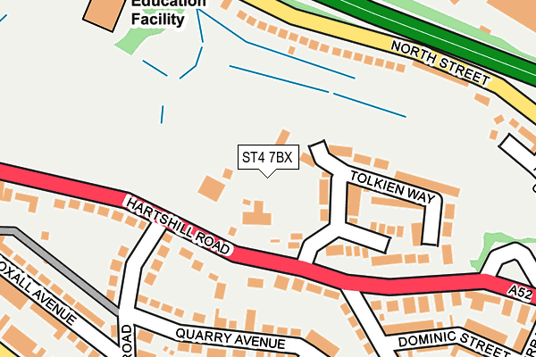
ST4 7BX is located in the Hartshill Park & Stoke electoral ward, within the unitary authority of Stoke-on-Trent and the English Parliamentary constituency of Stoke-on-Trent Central. The Sub Integrated Care Board (ICB) Location is NHS Staffordshire and Stoke-on-Trent ICB - 05W and the police force is Staffordshire. This postcode has been in use since July 2013.


GetTheData
Source: OS OpenMap – Local (Ordnance Survey)
Source: OS VectorMap District (Ordnance Survey)
Licence: Open Government Licence (requires attribution)
| Easting | 387003 |
| Northing | 345803 |
| Latitude | 53.009376 |
| Longitude | -2.195152 |
GetTheData
Source: Open Postcode Geo
Licence: Open Government Licence
| Country | England |
| Postcode District | ST4 |
➜ See where ST4 is on a map ➜ Where is Stoke-on-Trent? | |
GetTheData
Source: Land Registry Price Paid Data
Licence: Open Government Licence
Elevation or altitude of ST4 7BX as distance above sea level:
| Metres | Feet | |
|---|---|---|
| Elevation | 150m | 492ft |
Elevation is measured from the approximate centre of the postcode, to the nearest point on an OS contour line from OS Terrain 50, which has contour spacing of ten vertical metres.
➜ How high above sea level am I? Find the elevation of your current position using your device's GPS.
GetTheData
Source: Open Postcode Elevation
Licence: Open Government Licence
| Ward | Hartshill Park & Stoke |
| Constituency | Stoke-on-trent Central |
GetTheData
Source: ONS Postcode Database
Licence: Open Government Licence
| Tolkien Way (Hartshill Road) | Stoke-upon-trent | 85m |
| Quarry Road (Hartshill Road) | Hartshill | 118m |
| Richmond Street (Hartshill Road) | Stoke-upon-trent | 131m |
| Quarry Road (Hartshill Road) | Hartshill | 135m |
| Accident Unit (Princes Road) | Hartshill | 339m |
| Stoke-on-Trent Station | 1km |
| Longport Station | 3.9km |
| Longton Station | 4.5km |
GetTheData
Source: NaPTAN
Licence: Open Government Licence
GetTheData
Source: ONS Postcode Database
Licence: Open Government Licence


➜ Get more ratings from the Food Standards Agency
GetTheData
Source: Food Standards Agency
Licence: FSA terms & conditions
| Last Collection | |||
|---|---|---|---|
| Location | Mon-Fri | Sat | Distance |
| The Avenue | 17:30 | 09:45 | 704m |
| Trade Street | 18:30 | 10:00 | 810m |
| Stoke Railway Station | 18:00 | 12:00 | 976m |
GetTheData
Source: Dracos
Licence: Creative Commons Attribution-ShareAlike
The below table lists the International Territorial Level (ITL) codes (formerly Nomenclature of Territorial Units for Statistics (NUTS) codes) and Local Administrative Units (LAU) codes for ST4 7BX:
| ITL 1 Code | Name |
|---|---|
| TLG | West Midlands (England) |
| ITL 2 Code | Name |
| TLG2 | Shropshire and Staffordshire |
| ITL 3 Code | Name |
| TLG23 | Stoke-on-Trent |
| LAU 1 Code | Name |
| E06000021 | Stoke-on-Trent |
GetTheData
Source: ONS Postcode Directory
Licence: Open Government Licence
The below table lists the Census Output Area (OA), Lower Layer Super Output Area (LSOA), and Middle Layer Super Output Area (MSOA) for ST4 7BX:
| Code | Name | |
|---|---|---|
| OA | E00072162 | |
| LSOA | E01014291 | Stoke-on-Trent 018D |
| MSOA | E02002968 | Stoke-on-Trent 018 |
GetTheData
Source: ONS Postcode Directory
Licence: Open Government Licence
| ST4 7NE | Hartshill Road | 115m |
| ST4 7SJ | Tolkien Way | 120m |
| ST4 7SL | Hallahan Grove | 148m |
| ST4 7EW | Quarry Avenue | 168m |
| ST4 7DG | North Street | 171m |
| ST4 7ER | Quarry Road | 193m |
| ST4 7EP | Quarry Avenue | 200m |
| ST4 7DX | Richmond Street | 223m |
| ST4 7ES | Quarry Road | 246m |
| ST4 7EJ | Oxford Street | 247m |
GetTheData
Source: Open Postcode Geo; Land Registry Price Paid Data
Licence: Open Government Licence