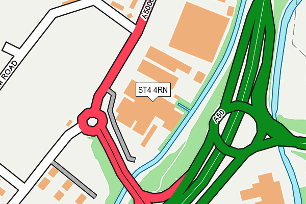
ST4 4RN is located in the Boothen electoral ward, within the unitary authority of Stoke-on-Trent and the English Parliamentary constituency of Stoke-on-Trent Central. The Sub Integrated Care Board (ICB) Location is NHS Staffordshire and Stoke-on-Trent ICB - 05W and the police force is Staffordshire. This postcode has been in use since July 1986.


GetTheData
Source: OS OpenMap – Local (Ordnance Survey)
Source: OS VectorMap District (Ordnance Survey)
Licence: Open Government Licence (requires attribution)
| Easting | 387637 |
| Northing | 343760 |
| Latitude | 52.991027 |
| Longitude | -2.185624 |
GetTheData
Source: Open Postcode Geo
Licence: Open Government Licence
| Country | England |
| Postcode District | ST4 |
➜ See where ST4 is on a map ➜ Where is Stoke-on-Trent? | |
GetTheData
Source: Land Registry Price Paid Data
Licence: Open Government Licence
Elevation or altitude of ST4 4RN as distance above sea level:
| Metres | Feet | |
|---|---|---|
| Elevation | 110m | 361ft |
Elevation is measured from the approximate centre of the postcode, to the nearest point on an OS contour line from OS Terrain 50, which has contour spacing of ten vertical metres.
➜ How high above sea level am I? Find the elevation of your current position using your device's GPS.
GetTheData
Source: Open Postcode Elevation
Licence: Open Government Licence
| Ward | Boothen |
| Constituency | Stoke-on-trent Central |
GetTheData
Source: ONS Postcode Database
Licence: Open Government Licence
| Campbell Road | Sideway | 96m |
| Campbell Road | Sideway | 99m |
| Queensway (Campbell Road) | Sideway | 110m |
| Queensway (Campbell Road) | Sideway | 132m |
| Plough Motel (Campbell Road) | Boothen | 269m |
| Stoke-on-Trent Station | 1.9km |
| Longton Station | 3.3km |
| Wedgwood Station | 4.6km |
GetTheData
Source: NaPTAN
Licence: Open Government Licence
GetTheData
Source: ONS Postcode Database
Licence: Open Government Licence


➜ Get more ratings from the Food Standards Agency
GetTheData
Source: Food Standards Agency
Licence: FSA terms & conditions
| Last Collection | |||
|---|---|---|---|
| Location | Mon-Fri | Sat | Distance |
| Fletcher Road | 18:00 | 09:45 | 453m |
| Corporation Street | 18:00 | 10:00 | 739m |
| London Road Post Office | 18:00 | 10:00 | 859m |
GetTheData
Source: Dracos
Licence: Creative Commons Attribution-ShareAlike
The below table lists the International Territorial Level (ITL) codes (formerly Nomenclature of Territorial Units for Statistics (NUTS) codes) and Local Administrative Units (LAU) codes for ST4 4RN:
| ITL 1 Code | Name |
|---|---|
| TLG | West Midlands (England) |
| ITL 2 Code | Name |
| TLG2 | Shropshire and Staffordshire |
| ITL 3 Code | Name |
| TLG23 | Stoke-on-Trent |
| LAU 1 Code | Name |
| E06000021 | Stoke-on-Trent |
GetTheData
Source: ONS Postcode Directory
Licence: Open Government Licence
The below table lists the Census Output Area (OA), Lower Layer Super Output Area (LSOA), and Middle Layer Super Output Area (MSOA) for ST4 4RN:
| Code | Name | |
|---|---|---|
| OA | E00072405 | |
| LSOA | E01014343 | Stoke-on-Trent 023D |
| MSOA | E02002973 | Stoke-on-Trent 023 |
GetTheData
Source: ONS Postcode Directory
Licence: Open Government Licence
| ST4 4BY | Bannister Close | 218m |
| ST4 4RJ | Campbell Road | 231m |
| ST4 4BZ | South Terrace Court | 250m |
| ST4 4BD | Holm Close | 285m |
| ST4 4BH | Sideway Road | 297m |
| ST4 4BG | South Terrace | 304m |
| ST4 4BQ | Water Street | 384m |
| ST4 4BJ | Boothen Green | 385m |
| ST4 4BE | Fletcher Road | 401m |
| ST4 4FB | Campbell Road | 423m |
GetTheData
Source: Open Postcode Geo; Land Registry Price Paid Data
Licence: Open Government Licence