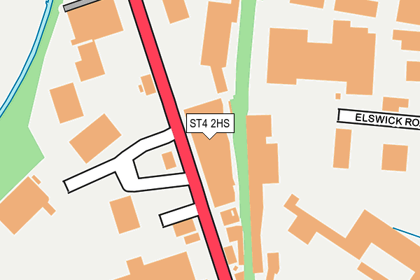
ST4 2HS lies on Victoria Road in Stoke-on-trent. ST4 2HS is located in the Hanley Park, Joiner's Square & Shelton electoral ward, within the unitary authority of Stoke-on-Trent and the English Parliamentary constituency of Stoke-on-Trent Central. The Sub Integrated Care Board (ICB) Location is NHS Staffordshire and Stoke-on-Trent ICB - 05W and the police force is Staffordshire. This postcode has been in use since January 1980.


GetTheData
Source: OS OpenMap – Local (Ordnance Survey)
Source: OS VectorMap District (Ordnance Survey)
Licence: Open Government Licence (requires attribution)
| Easting | 389037 |
| Northing | 345748 |
| Latitude | 53.008945 |
| Longitude | -2.164835 |
GetTheData
Source: Open Postcode Geo
Licence: Open Government Licence
| Street | Victoria Road |
| Town/City | Stoke-on-trent |
| Country | England |
| Postcode District | ST4 |
➜ See where ST4 is on a map ➜ Where is Stoke-on-Trent? | |
GetTheData
Source: Land Registry Price Paid Data
Licence: Open Government Licence
Elevation or altitude of ST4 2HS as distance above sea level:
| Metres | Feet | |
|---|---|---|
| Elevation | 120m | 394ft |
Elevation is measured from the approximate centre of the postcode, to the nearest point on an OS contour line from OS Terrain 50, which has contour spacing of ten vertical metres.
➜ How high above sea level am I? Find the elevation of your current position using your device's GPS.
GetTheData
Source: Open Postcode Elevation
Licence: Open Government Licence
| Ward | Hanley Park, Joiner's Square & Shelton |
| Constituency | Stoke-on-trent Central |
GetTheData
Source: ONS Postcode Database
Licence: Open Government Licence
| Sixth Form College (Victoria Road) | Fenton | 69m |
| Sixth Form College (Victoria Road) | Fenton | 156m |
| Berry Hill Road (Victoria Road) | Joiners Square | 314m |
| Berry Hill Road (Victoria Road) | Joiners Square | 458m |
| Alfred Street (Victoria Road) | Fenton | 556m |
| Stoke-on-Trent Station | 1.1km |
| Longton Station | 2.8km |
| Longport Station | 5km |
GetTheData
Source: NaPTAN
Licence: Open Government Licence
| Median download speed | 7.7Mbps |
| Average download speed | 7.7Mbps |
| Maximum download speed | 10.28Mbps |
| Median upload speed | 1.0Mbps |
| Average upload speed | 0.9Mbps |
| Maximum upload speed | 1.10Mbps |
GetTheData
Source: Ofcom
Licence: Ofcom Terms of Use (requires attribution)
GetTheData
Source: ONS Postcode Database
Licence: Open Government Licence


➜ Get more ratings from the Food Standards Agency
GetTheData
Source: Food Standards Agency
Licence: FSA terms & conditions
| Last Collection | |||
|---|---|---|---|
| Location | Mon-Fri | Sat | Distance |
| Royal Mail | 19:00 | 13:00 | 146m |
| James Street | 18:00 | 09:45 | 400m |
| Manor Street | 17:45 | 11:30 | 508m |
GetTheData
Source: Dracos
Licence: Creative Commons Attribution-ShareAlike
The below table lists the International Territorial Level (ITL) codes (formerly Nomenclature of Territorial Units for Statistics (NUTS) codes) and Local Administrative Units (LAU) codes for ST4 2HS:
| ITL 1 Code | Name |
|---|---|
| TLG | West Midlands (England) |
| ITL 2 Code | Name |
| TLG2 | Shropshire and Staffordshire |
| ITL 3 Code | Name |
| TLG23 | Stoke-on-Trent |
| LAU 1 Code | Name |
| E06000021 | Stoke-on-Trent |
GetTheData
Source: ONS Postcode Directory
Licence: Open Government Licence
The below table lists the Census Output Area (OA), Lower Layer Super Output Area (LSOA), and Middle Layer Super Output Area (MSOA) for ST4 2HS:
| Code | Name | |
|---|---|---|
| OA | E00071836 | |
| LSOA | E01033216 | Stoke-on-Trent 016G |
| MSOA | E02002966 | Stoke-on-Trent 016 |
GetTheData
Source: ONS Postcode Directory
Licence: Open Government Licence
| ST4 2HU | Victoria Road | 137m |
| ST4 2HX | Victoria Road | 219m |
| ST4 2XB | Ravenside Retail Park | 225m |
| ST4 2TE | Dewsbury Road | 321m |
| ST4 2LZ | Hayfield Crescent | 485m |
| ST4 2SL | Morville Close | 519m |
| ST4 2HH | Alfred Street | 560m |
| ST4 2SW | Crabtree Close | 571m |
| ST4 2JD | Manor Street | 597m |
| ST4 2JB | Manor Street | 606m |
GetTheData
Source: Open Postcode Geo; Land Registry Price Paid Data
Licence: Open Government Licence