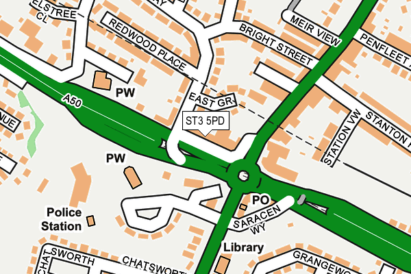
ST3 5PD is located in the Meir North electoral ward, within the unitary authority of Stoke-on-Trent and the English Parliamentary constituency of Stoke-on-Trent South. The Sub Integrated Care Board (ICB) Location is NHS Staffordshire and Stoke-on-Trent ICB - 05W and the police force is Staffordshire. This postcode has been in use since January 1980.


GetTheData
Source: OS OpenMap – Local (Ordnance Survey)
Source: OS VectorMap District (Ordnance Survey)
Licence: Open Government Licence (requires attribution)
| Easting | 393060 |
| Northing | 342330 |
| Latitude | 52.978271 |
| Longitude | -2.104805 |
GetTheData
Source: Open Postcode Geo
Licence: Open Government Licence
| Country | England |
| Postcode District | ST3 |
➜ See where ST3 is on a map ➜ Where is Stoke-on-Trent? | |
GetTheData
Source: Land Registry Price Paid Data
Licence: Open Government Licence
Elevation or altitude of ST3 5PD as distance above sea level:
| Metres | Feet | |
|---|---|---|
| Elevation | 200m | 656ft |
Elevation is measured from the approximate centre of the postcode, to the nearest point on an OS contour line from OS Terrain 50, which has contour spacing of ten vertical metres.
➜ How high above sea level am I? Find the elevation of your current position using your device's GPS.
GetTheData
Source: Open Postcode Elevation
Licence: Open Government Licence
| Ward | Meir North |
| Constituency | Stoke-on-trent South |
GetTheData
Source: ONS Postcode Database
Licence: Open Government Licence
| Broadway (Uttoxeter Road) | Meir | 19m |
| Broadway (Uttoxeter Road) | Meir | 53m |
| Late Shop (Weston Road) | Meir | 121m |
| Late Shop (Weston Road) | Meir | 125m |
| Meir Youth Centre (Sandon Road) | Meir | 155m |
| Longton Station | 2.5km |
| Blythe Bridge Station | 2.8km |
| Wedgwood Station | 5.4km |
GetTheData
Source: NaPTAN
Licence: Open Government Licence
GetTheData
Source: ONS Postcode Database
Licence: Open Government Licence


➜ Get more ratings from the Food Standards Agency
GetTheData
Source: Food Standards Agency
Licence: FSA terms & conditions
| Last Collection | |||
|---|---|---|---|
| Location | Mon-Fri | Sat | Distance |
| Normacot Post Office | 17:00 | 12:00 | 1,366m |
| Lilleshall Street | 16:00 | 11:00 | 1,704m |
| Gladstone Pottery | 14:45 | 2,039m | |
GetTheData
Source: Dracos
Licence: Creative Commons Attribution-ShareAlike
The below table lists the International Territorial Level (ITL) codes (formerly Nomenclature of Territorial Units for Statistics (NUTS) codes) and Local Administrative Units (LAU) codes for ST3 5PD:
| ITL 1 Code | Name |
|---|---|
| TLG | West Midlands (England) |
| ITL 2 Code | Name |
| TLG2 | Shropshire and Staffordshire |
| ITL 3 Code | Name |
| TLG23 | Stoke-on-Trent |
| LAU 1 Code | Name |
| E06000021 | Stoke-on-Trent |
GetTheData
Source: ONS Postcode Directory
Licence: Open Government Licence
The below table lists the Census Output Area (OA), Lower Layer Super Output Area (LSOA), and Middle Layer Super Output Area (MSOA) for ST3 5PD:
| Code | Name | |
|---|---|---|
| OA | E00072294 | |
| LSOA | E01014321 | Stoke-on-Trent 028A |
| MSOA | E02002978 | Stoke-on-Trent 028 |
GetTheData
Source: ONS Postcode Directory
Licence: Open Government Licence
| ST3 5PG | East Grove | 58m |
| ST3 5PX | Broadway | 61m |
| ST3 5PF | Broadway | 88m |
| ST3 6AE | Smiths Buildings | 94m |
| ST3 7DT | Sandon Road | 114m |
| ST3 7AE | Uttoxeter Road | 120m |
| ST3 6AB | Weston Road | 128m |
| ST3 6AF | Cornelious Street | 144m |
| ST3 6AQ | Bright Street | 156m |
| ST3 6AG | Bright Street | 163m |
GetTheData
Source: Open Postcode Geo; Land Registry Price Paid Data
Licence: Open Government Licence