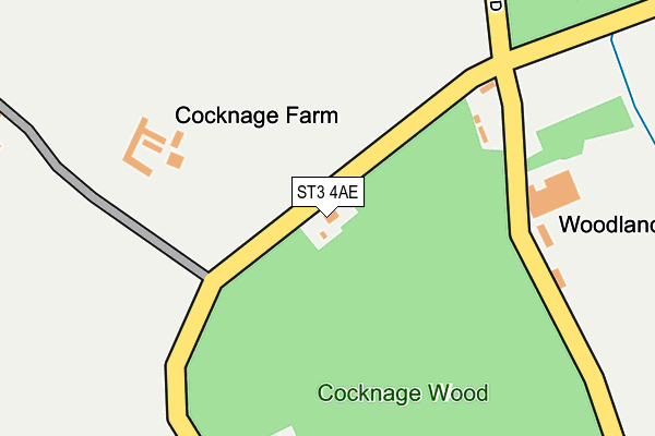
ST3 4AE lies on Cocknage in Stoke-on-trent. ST3 4AE is located in the Barlaston electoral ward, within the local authority district of Stafford and the English Parliamentary constituency of Stone. The Sub Integrated Care Board (ICB) Location is NHS Staffordshire and Stoke-on-Trent ICB - 05V and the police force is Staffordshire. This postcode has been in use since January 1980.


GetTheData
Source: OS OpenMap – Local (Ordnance Survey)
Source: OS VectorMap District (Ordnance Survey)
Licence: Open Government Licence (requires attribution)
| Easting | 391195 |
| Northing | 340924 |
| Latitude | 52.965621 |
| Longitude | -2.132541 |
GetTheData
Source: Open Postcode Geo
Licence: Open Government Licence
| Street | Cocknage |
| Town/City | Stoke-on-trent |
| Country | England |
| Postcode District | ST3 |
➜ See where ST3 is on a map | |
GetTheData
Source: Land Registry Price Paid Data
Licence: Open Government Licence
Elevation or altitude of ST3 4AE as distance above sea level:
| Metres | Feet | |
|---|---|---|
| Elevation | 190m | 623ft |
Elevation is measured from the approximate centre of the postcode, to the nearest point on an OS contour line from OS Terrain 50, which has contour spacing of ten vertical metres.
➜ How high above sea level am I? Find the elevation of your current position using your device's GPS.
GetTheData
Source: Open Postcode Elevation
Licence: Open Government Licence
| Ward | Barlaston |
| Constituency | Stone |
GetTheData
Source: ONS Postcode Database
Licence: Open Government Licence
| Queens Park Avenue | Dresden | 1,115m |
| Queens Park Avenue | Dresden | 1,119m |
| Chaplin Road | Dresden | 1,235m |
| Chaplin Road | Dresden | 1,237m |
| Barlaston Road | Newstead | 1,238m |
| Longton Station | 2.7km |
| Wedgwood Station | 3km |
| Barlaston Station | 3.5km |
GetTheData
Source: NaPTAN
Licence: Open Government Licence
| Percentage of properties with Next Generation Access | 100.0% |
| Percentage of properties with Superfast Broadband | 20.0% |
| Percentage of properties with Ultrafast Broadband | 20.0% |
| Percentage of properties with Full Fibre Broadband | 0.0% |
Superfast Broadband is between 30Mbps and 300Mbps
Ultrafast Broadband is > 300Mbps
| Median download speed | 13.1Mbps |
| Average download speed | 11.4Mbps |
| Maximum download speed | 19.83Mbps |
| Median upload speed | 0.9Mbps |
| Average upload speed | 1.8Mbps |
| Maximum upload speed | 3.82Mbps |
| Percentage of properties unable to receive 2Mbps | 0.0% |
| Percentage of properties unable to receive 5Mbps | 0.0% |
| Percentage of properties unable to receive 10Mbps | 0.0% |
| Percentage of properties unable to receive 30Mbps | 80.0% |
GetTheData
Source: Ofcom
Licence: Ofcom Terms of Use (requires attribution)
GetTheData
Source: ONS Postcode Database
Licence: Open Government Licence


➜ Get more ratings from the Food Standards Agency
GetTheData
Source: Food Standards Agency
Licence: FSA terms & conditions
| Last Collection | |||
|---|---|---|---|
| Location | Mon-Fri | Sat | Distance |
| Newstead Post Office | 16:30 | 11:30 | 1,461m |
| Dresden Post Office | 16:30 | 12:00 | 1,523m |
| Trentham Road | 16:30 | 12:30 | 1,563m |
GetTheData
Source: Dracos
Licence: Creative Commons Attribution-ShareAlike
The below table lists the International Territorial Level (ITL) codes (formerly Nomenclature of Territorial Units for Statistics (NUTS) codes) and Local Administrative Units (LAU) codes for ST3 4AE:
| ITL 1 Code | Name |
|---|---|
| TLG | West Midlands (England) |
| ITL 2 Code | Name |
| TLG2 | Shropshire and Staffordshire |
| ITL 3 Code | Name |
| TLG24 | Staffordshire CC |
| LAU 1 Code | Name |
| E07000197 | Stafford |
GetTheData
Source: ONS Postcode Directory
Licence: Open Government Licence
The below table lists the Census Output Area (OA), Lower Layer Super Output Area (LSOA), and Middle Layer Super Output Area (MSOA) for ST3 4AE:
| Code | Name | |
|---|---|---|
| OA | E00151238 | |
| LSOA | E01029681 | Stafford 002A |
| MSOA | E02006189 | Stafford 002 |
GetTheData
Source: ONS Postcode Directory
Licence: Open Government Licence
| ST3 4AF | Woodpark Lane | 433m |
| ST3 4AD | Woodpark Lane | 558m |
| ST3 4AB | Cocknage Road | 645m |
| ST3 4AH | Cocknage | 658m |
| ST3 4AW | Cocknage Road | 752m |
| ST3 4UB | Palomino Close | 764m |
| ST3 4AJ | Cocknage | 796m |
| ST3 4TU | Romney Grove | 817m |
| ST3 4UD | Ryeland Close | 831m |
| ST3 4UA | Southdown Close | 872m |
GetTheData
Source: Open Postcode Geo; Land Registry Price Paid Data
Licence: Open Government Licence