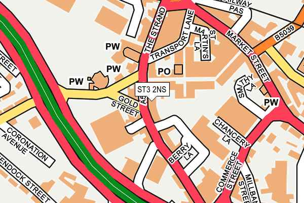
ST3 2NS lies on The Strand in Stoke-on-trent. ST3 2NS is located in the Longton & Meir Hay South electoral ward, within the unitary authority of Stoke-on-Trent and the English Parliamentary constituency of Stoke-on-Trent South. The Sub Integrated Care Board (ICB) Location is NHS Staffordshire and Stoke-on-Trent ICB - 05W and the police force is Staffordshire. This postcode has been in use since January 1980.


GetTheData
Source: OS OpenMap – Local (Ordnance Survey)
Source: OS VectorMap District (Ordnance Survey)
Licence: Open Government Licence (requires attribution)
| Easting | 390922 |
| Northing | 343388 |
| Latitude | 52.987766 |
| Longitude | -2.136675 |
GetTheData
Source: Open Postcode Geo
Licence: Open Government Licence
| Street | The Strand |
| Town/City | Stoke-on-trent |
| Country | England |
| Postcode District | ST3 |
➜ See where ST3 is on a map ➜ Where is Stoke-on-Trent? | |
GetTheData
Source: Land Registry Price Paid Data
Licence: Open Government Licence
Elevation or altitude of ST3 2NS as distance above sea level:
| Metres | Feet | |
|---|---|---|
| Elevation | 150m | 492ft |
Elevation is measured from the approximate centre of the postcode, to the nearest point on an OS contour line from OS Terrain 50, which has contour spacing of ten vertical metres.
➜ How high above sea level am I? Find the elevation of your current position using your device's GPS.
GetTheData
Source: Open Postcode Elevation
Licence: Open Government Licence
| Ward | Longton & Meir Hay South |
| Constituency | Stoke-on-trent South |
GetTheData
Source: ONS Postcode Database
Licence: Open Government Licence
97 - 99, THE STRAND, STOKE-ON-TRENT, ST3 2NS 2006 10 MAR £190,000 |
97 - 99, THE STRAND, STOKE-ON-TRENT, ST3 2NS 2002 16 SEP £102,500 |
GetTheData
Source: HM Land Registry Price Paid Data
Licence: Contains HM Land Registry data © Crown copyright and database right 2025. This data is licensed under the Open Government Licence v3.0.
| Stop C (The Strand) | Longton | 41m |
| Stop B (The Strand) | Longton | 132m |
| Heathcote Road | Longton | 248m |
| Alighting Stop (Caroline Street) | Longton | 263m |
| Longton Police Station (Sutherland Road) | Longton | 264m |
| Longton Station | 0.2km |
| Stoke-on-Trent Station | 3.7km |
| Wedgwood Station | 4.7km |
GetTheData
Source: NaPTAN
Licence: Open Government Licence
| Median download speed | 20.0Mbps |
| Average download speed | 21.5Mbps |
| Maximum download speed | 72.73Mbps |
| Median upload speed | 1.1Mbps |
| Average upload speed | 2.6Mbps |
| Maximum upload speed | 20.00Mbps |
GetTheData
Source: Ofcom
Licence: Ofcom Terms of Use (requires attribution)
GetTheData
Source: ONS Postcode Database
Licence: Open Government Licence


➜ Get more ratings from the Food Standards Agency
GetTheData
Source: Food Standards Agency
Licence: FSA terms & conditions
| Last Collection | |||
|---|---|---|---|
| Location | Mon-Fri | Sat | Distance |
| The Strand | 17:30 | 11:00 | 143m |
| Gladstone Pottery | 14:45 | 352m | |
| Ashwood | 18:00 | 10:15 | 659m |
GetTheData
Source: Dracos
Licence: Creative Commons Attribution-ShareAlike
The below table lists the International Territorial Level (ITL) codes (formerly Nomenclature of Territorial Units for Statistics (NUTS) codes) and Local Administrative Units (LAU) codes for ST3 2NS:
| ITL 1 Code | Name |
|---|---|
| TLG | West Midlands (England) |
| ITL 2 Code | Name |
| TLG2 | Shropshire and Staffordshire |
| ITL 3 Code | Name |
| TLG23 | Stoke-on-Trent |
| LAU 1 Code | Name |
| E06000021 | Stoke-on-Trent |
GetTheData
Source: ONS Postcode Directory
Licence: Open Government Licence
The below table lists the Census Output Area (OA), Lower Layer Super Output Area (LSOA), and Middle Layer Super Output Area (MSOA) for ST3 2NS:
| Code | Name | |
|---|---|---|
| OA | E00072209 | |
| LSOA | E01014302 | Stoke-on-Trent 022D |
| MSOA | E02002972 | Stoke-on-Trent 022 |
GetTheData
Source: ONS Postcode Directory
Licence: Open Government Licence
| ST3 2JW | Gold Street | 41m |
| ST3 2JN | The Strand | 41m |
| ST3 2NR | The Strand | 61m |
| ST3 2NU | Edensor Road | 80m |
| ST3 2JR | Heathcote Road | 82m |
| ST3 2PD | The Strand | 176m |
| ST3 1BX | Market Street | 188m |
| ST3 1BS | Market Street | 208m |
| ST3 1BE | Market Street | 226m |
| ST3 1EL | Wood Street | 241m |
GetTheData
Source: Open Postcode Geo; Land Registry Price Paid Data
Licence: Open Government Licence