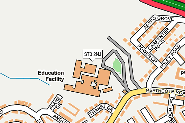
ST3 2NJ is located in the Hollybush electoral ward, within the unitary authority of Stoke-on-Trent and the English Parliamentary constituency of Stoke-on-Trent South. The Sub Integrated Care Board (ICB) Location is NHS Staffordshire and Stoke-on-Trent ICB - 05W and the police force is Staffordshire. This postcode has been in use since January 1980.


GetTheData
Source: OS OpenMap – Local (Ordnance Survey)
Source: OS VectorMap District (Ordnance Survey)
Licence: Open Government Licence (requires attribution)
| Easting | 390203 |
| Northing | 343407 |
| Latitude | 52.987924 |
| Longitude | -2.147386 |
GetTheData
Source: Open Postcode Geo
Licence: Open Government Licence
| Country | England |
| Postcode District | ST3 |
➜ See where ST3 is on a map ➜ Where is Stoke-on-Trent? | |
GetTheData
Source: Land Registry Price Paid Data
Licence: Open Government Licence
Elevation or altitude of ST3 2NJ as distance above sea level:
| Metres | Feet | |
|---|---|---|
| Elevation | 150m | 492ft |
Elevation is measured from the approximate centre of the postcode, to the nearest point on an OS contour line from OS Terrain 50, which has contour spacing of ten vertical metres.
➜ How high above sea level am I? Find the elevation of your current position using your device's GPS.
GetTheData
Source: Open Postcode Elevation
Licence: Open Government Licence
| Ward | Hollybush |
| Constituency | Stoke-on-trent South |
GetTheData
Source: ONS Postcode Database
Licence: Open Government Licence
| Thanet Grove (Longton Hall Road) | Longton | 110m |
| Heathcote Road (Foley Road) | Longton | 172m |
| The Red House (Heathcote Road) | Longton | 214m |
| The John Marston (Longton Hall Road) | Blurton | 282m |
| The John Marston (Longton Hall Road) | Blurton | 283m |
| Longton Station | 0.7km |
| Stoke-on-Trent Station | 3.2km |
| Wedgwood Station | 4.4km |
GetTheData
Source: NaPTAN
Licence: Open Government Licence
GetTheData
Source: ONS Postcode Database
Licence: Open Government Licence


➜ Get more ratings from the Food Standards Agency
GetTheData
Source: Food Standards Agency
Licence: FSA terms & conditions
| Last Collection | |||
|---|---|---|---|
| Location | Mon-Fri | Sat | Distance |
| King Street Old Post Office | 17:30 | 12:00 | 722m |
| East Fenton Post Office | 17:15 | 12:00 | 727m |
| The Strand | 17:30 | 11:00 | 780m |
GetTheData
Source: Dracos
Licence: Creative Commons Attribution-ShareAlike
The below table lists the International Territorial Level (ITL) codes (formerly Nomenclature of Territorial Units for Statistics (NUTS) codes) and Local Administrative Units (LAU) codes for ST3 2NJ:
| ITL 1 Code | Name |
|---|---|
| TLG | West Midlands (England) |
| ITL 2 Code | Name |
| TLG2 | Shropshire and Staffordshire |
| ITL 3 Code | Name |
| TLG23 | Stoke-on-Trent |
| LAU 1 Code | Name |
| E06000021 | Stoke-on-Trent |
GetTheData
Source: ONS Postcode Directory
Licence: Open Government Licence
The below table lists the Census Output Area (OA), Lower Layer Super Output Area (LSOA), and Middle Layer Super Output Area (MSOA) for ST3 2NJ:
| Code | Name | |
|---|---|---|
| OA | E00072256 | |
| LSOA | E01014313 | Stoke-on-Trent 027D |
| MSOA | E02002977 | Stoke-on-Trent 027 |
GetTheData
Source: ONS Postcode Directory
Licence: Open Government Licence
| ST3 2NH | Thanet Grove | 112m |
| ST3 2NG | Longton Hall Road | 134m |
| ST3 2SW | Bardsey Walk | 148m |
| ST3 2LN | Power Grove | 149m |
| ST3 2SP | Guernsey Walk | 160m |
| ST3 2ST | Farne Grove | 167m |
| ST3 2NQ | Longton Hall Road | 184m |
| ST3 2RX | Warminster Place | 197m |
| ST3 2NF | Heathcote Road | 197m |
| ST3 2RY | Corby Place | 200m |
GetTheData
Source: Open Postcode Geo; Land Registry Price Paid Data
Licence: Open Government Licence