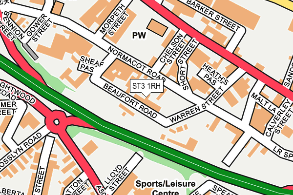
ST3 1RH lies on Beaufort Road in Stoke-on-trent. ST3 1RH is located in the Longton & Meir Hay South electoral ward, within the unitary authority of Stoke-on-Trent and the English Parliamentary constituency of Stoke-on-Trent South. The Sub Integrated Care Board (ICB) Location is NHS Staffordshire and Stoke-on-Trent ICB - 05W and the police force is Staffordshire. This postcode has been in use since October 1985.


GetTheData
Source: OS OpenMap – Local (Ordnance Survey)
Source: OS VectorMap District (Ordnance Survey)
Licence: Open Government Licence (requires attribution)
| Easting | 391398 |
| Northing | 342983 |
| Latitude | 52.984134 |
| Longitude | -2.129574 |
GetTheData
Source: Open Postcode Geo
Licence: Open Government Licence
| Street | Beaufort Road |
| Town/City | Stoke-on-trent |
| Country | England |
| Postcode District | ST3 |
➜ See where ST3 is on a map ➜ Where is Stoke-on-Trent? | |
GetTheData
Source: Land Registry Price Paid Data
Licence: Open Government Licence
Elevation or altitude of ST3 1RH as distance above sea level:
| Metres | Feet | |
|---|---|---|
| Elevation | 160m | 525ft |
Elevation is measured from the approximate centre of the postcode, to the nearest point on an OS contour line from OS Terrain 50, which has contour spacing of ten vertical metres.
➜ How high above sea level am I? Find the elevation of your current position using your device's GPS.
GetTheData
Source: Open Postcode Elevation
Licence: Open Government Licence
| Ward | Longton & Meir Hay South |
| Constituency | Stoke-on-trent South |
GetTheData
Source: ONS Postcode Database
Licence: Open Government Licence
| Longton Library (Lightwood Road) | Longton | 178m |
| St James' Church (Uttoxeter Road) | Longton | 180m |
| Dunrobin Street (Lightwood Road) | Longton | 187m |
| St James' Church (Uttoxeter Road) | Longton | 189m |
| The Dunrobin (Lightwood Road) | Longton | 256m |
| Longton Station | 0.8km |
| Stoke-on-Trent Station | 4.4km |
| Blythe Bridge Station | 4.6km |
GetTheData
Source: NaPTAN
Licence: Open Government Licence
| Percentage of properties with Next Generation Access | 100.0% |
| Percentage of properties with Superfast Broadband | 100.0% |
| Percentage of properties with Ultrafast Broadband | 100.0% |
| Percentage of properties with Full Fibre Broadband | 0.0% |
Superfast Broadband is between 30Mbps and 300Mbps
Ultrafast Broadband is > 300Mbps
| Percentage of properties unable to receive 2Mbps | 0.0% |
| Percentage of properties unable to receive 5Mbps | 0.0% |
| Percentage of properties unable to receive 10Mbps | 0.0% |
| Percentage of properties unable to receive 30Mbps | 0.0% |
GetTheData
Source: Ofcom
Licence: Ofcom Terms of Use (requires attribution)
Estimated total energy consumption in ST3 1RH by fuel type, 2015.
| Consumption (kWh) | 64,069 |
|---|---|
| Meter count | 10 |
| Mean (kWh/meter) | 6,407 |
| Median (kWh/meter) | 4,049 |
| Consumption (kWh) | 100,469 |
|---|---|
| Meter count | 19 |
| Mean (kWh/meter) | 5,288 |
| Median (kWh/meter) | 5,464 |
GetTheData
Source: Postcode level gas estimates: 2015 (experimental)
Source: Postcode level electricity estimates: 2015 (experimental)
Licence: Open Government Licence
GetTheData
Source: ONS Postcode Database
Licence: Open Government Licence

➜ Get more ratings from the Food Standards Agency
GetTheData
Source: Food Standards Agency
Licence: FSA terms & conditions
| Last Collection | |||
|---|---|---|---|
| Location | Mon-Fri | Sat | Distance |
| Lilleshall Street | 16:00 | 11:00 | 332m |
| Gladstone Pottery | 14:45 | 334m | |
| The Strand | 17:30 | 11:00 | 508m |
GetTheData
Source: Dracos
Licence: Creative Commons Attribution-ShareAlike
The below table lists the International Territorial Level (ITL) codes (formerly Nomenclature of Territorial Units for Statistics (NUTS) codes) and Local Administrative Units (LAU) codes for ST3 1RH:
| ITL 1 Code | Name |
|---|---|
| TLG | West Midlands (England) |
| ITL 2 Code | Name |
| TLG2 | Shropshire and Staffordshire |
| ITL 3 Code | Name |
| TLG23 | Stoke-on-Trent |
| LAU 1 Code | Name |
| E06000021 | Stoke-on-Trent |
GetTheData
Source: ONS Postcode Directory
Licence: Open Government Licence
The below table lists the Census Output Area (OA), Lower Layer Super Output Area (LSOA), and Middle Layer Super Output Area (MSOA) for ST3 1RH:
| Code | Name | |
|---|---|---|
| OA | E00072218 | |
| LSOA | E01014302 | Stoke-on-Trent 022D |
| MSOA | E02002972 | Stoke-on-Trent 022 |
GetTheData
Source: ONS Postcode Directory
Licence: Open Government Licence
| ST3 1PR | Normacot Road | 68m |
| ST3 1QD | Warren Street | 154m |
| ST3 4JF | Lightwood Road | 192m |
| ST3 1PH | Uttoxeter Road | 193m |
| ST3 1PF | Uttoxeter Road | 196m |
| ST3 4SY | Tatton Street | 218m |
| ST3 1RD | Locketts Lane | 245m |
| ST3 4LE | Cromartie Street | 250m |
| ST3 1QH | Uttoxeter Road | 255m |
| ST3 4JD | Rosslyn Road | 256m |
GetTheData
Source: Open Postcode Geo; Land Registry Price Paid Data
Licence: Open Government Licence