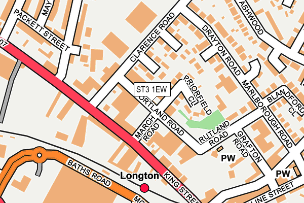
ST3 1EW lies on Portland Road in Stoke-on-trent. ST3 1EW is located in the Sandford Hill electoral ward, within the unitary authority of Stoke-on-Trent and the English Parliamentary constituency of Stoke-on-Trent South. The Sub Integrated Care Board (ICB) Location is NHS Staffordshire and Stoke-on-Trent ICB - 05W and the police force is Staffordshire. This postcode has been in use since January 1980.


GetTheData
Source: OS OpenMap – Local (Ordnance Survey)
Source: OS VectorMap District (Ordnance Survey)
Licence: Open Government Licence (requires attribution)
| Easting | 390870 |
| Northing | 343825 |
| Latitude | 52.991677 |
| Longitude | -2.137463 |
GetTheData
Source: Open Postcode Geo
Licence: Open Government Licence
| Street | Portland Road |
| Town/City | Stoke-on-trent |
| Country | England |
| Postcode District | ST3 |
➜ See where ST3 is on a map ➜ Where is Stoke-on-Trent? | |
GetTheData
Source: Land Registry Price Paid Data
Licence: Open Government Licence
Elevation or altitude of ST3 1EW as distance above sea level:
| Metres | Feet | |
|---|---|---|
| Elevation | 150m | 492ft |
Elevation is measured from the approximate centre of the postcode, to the nearest point on an OS contour line from OS Terrain 50, which has contour spacing of ten vertical metres.
➜ How high above sea level am I? Find the elevation of your current position using your device's GPS.
GetTheData
Source: Open Postcode Elevation
Licence: Open Government Licence
| Ward | Sandford Hill |
| Constituency | Stoke-on-trent South |
GetTheData
Source: ONS Postcode Database
Licence: Open Government Licence
2, PORTLAND ROAD, STOKE-ON-TRENT, ST3 1EW 2005 6 APR £50,000 |
2, PORTLAND ROAD, STOKE-ON-TRENT, ST3 1EW 2004 14 MAY £170,000 |
GetTheData
Source: HM Land Registry Price Paid Data
Licence: Contains HM Land Registry data © Crown copyright and database right 2025. This data is licensed under the Open Government Licence v3.0.
| March Road (King Street) | Longton | 84m |
| Stop E (King Street) | Longton | 115m |
| Alighting Stop (Caroline Street) | Longton | 281m |
| Smith Street (Ashwood) | Sandford Hill | 287m |
| Friar Street (Ashwood) | Sandford Hill | 324m |
| Longton Station | 0.2km |
| Stoke-on-Trent Station | 3.4km |
| Wedgwood Station | 5km |
GetTheData
Source: NaPTAN
Licence: Open Government Licence
GetTheData
Source: ONS Postcode Database
Licence: Open Government Licence


➜ Get more ratings from the Food Standards Agency
GetTheData
Source: Food Standards Agency
Licence: FSA terms & conditions
| Last Collection | |||
|---|---|---|---|
| Location | Mon-Fri | Sat | Distance |
| Ashwood | 18:00 | 10:15 | 336m |
| The Strand | 17:30 | 11:00 | 580m |
| King Street Old Post Office | 17:30 | 12:00 | 644m |
GetTheData
Source: Dracos
Licence: Creative Commons Attribution-ShareAlike
The below table lists the International Territorial Level (ITL) codes (formerly Nomenclature of Territorial Units for Statistics (NUTS) codes) and Local Administrative Units (LAU) codes for ST3 1EW:
| ITL 1 Code | Name |
|---|---|
| TLG | West Midlands (England) |
| ITL 2 Code | Name |
| TLG2 | Shropshire and Staffordshire |
| ITL 3 Code | Name |
| TLG23 | Stoke-on-Trent |
| LAU 1 Code | Name |
| E06000021 | Stoke-on-Trent |
GetTheData
Source: ONS Postcode Directory
Licence: Open Government Licence
The below table lists the Census Output Area (OA), Lower Layer Super Output Area (LSOA), and Middle Layer Super Output Area (MSOA) for ST3 1EW:
| Code | Name | |
|---|---|---|
| OA | E00072205 | |
| LSOA | E01014302 | Stoke-on-Trent 022D |
| MSOA | E02002972 | Stoke-on-Trent 022 |
GetTheData
Source: ONS Postcode Directory
Licence: Open Government Licence
| ST3 1EP | Priorfield Close | 61m |
| ST3 1BD | Kelmore Close | 83m |
| ST3 1EZ | King Street | 135m |
| ST3 1BB | Glenwood Close | 138m |
| ST3 1EG | Heathdene Close | 139m |
| ST4 3DN | Rill Street | 173m |
| ST3 1EH | Rutland Road | 181m |
| ST3 1BA | Drayton Road | 197m |
| ST4 3DL | Goldenhill Road | 209m |
| ST3 1DT | Ashwood | 233m |
GetTheData
Source: Open Postcode Geo; Land Registry Price Paid Data
Licence: Open Government Licence