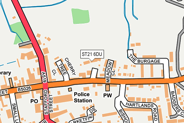
ST21 6DU lies on Southlands Court in Eccleshall, Stafford. ST21 6DU is located in the Eccleshall electoral ward, within the local authority district of Stafford and the English Parliamentary constituency of Stone. The Sub Integrated Care Board (ICB) Location is NHS Staffordshire and Stoke-on-Trent ICB - 05V and the police force is Staffordshire. This postcode has been in use since January 2005.


GetTheData
Source: OS OpenMap – Local (Ordnance Survey)
Source: OS VectorMap District (Ordnance Survey)
Licence: Open Government Licence (requires attribution)
| Easting | 383318 |
| Northing | 329250 |
| Latitude | 52.860476 |
| Longitude | -2.249214 |
GetTheData
Source: Open Postcode Geo
Licence: Open Government Licence
| Street | Southlands Court |
| Locality | Eccleshall |
| Town/City | Stafford |
| Country | England |
| Postcode District | ST21 |
➜ See where ST21 is on a map ➜ Where is Eccleshall? | |
GetTheData
Source: Land Registry Price Paid Data
Licence: Open Government Licence
Elevation or altitude of ST21 6DU as distance above sea level:
| Metres | Feet | |
|---|---|---|
| Elevation | 90m | 295ft |
Elevation is measured from the approximate centre of the postcode, to the nearest point on an OS contour line from OS Terrain 50, which has contour spacing of ten vertical metres.
➜ How high above sea level am I? Find the elevation of your current position using your device's GPS.
GetTheData
Source: Open Postcode Elevation
Licence: Open Government Licence
| Ward | Eccleshall |
| Constituency | Stone |
GetTheData
Source: ONS Postcode Database
Licence: Open Government Licence
2015 11 DEC £297,500 |
2013 18 MAR £305,000 |
3, SOUTHLANDS COURT, ECCLESHALL, STAFFORD, ST21 6DU 2008 21 FEB £335,000 |
5, SOUTHLANDS COURT, ECCLESHALL, STAFFORD, ST21 6DU 2005 25 APR £345,000 |
4, SOUTHLANDS COURT, ECCLESHALL, STAFFORD, ST21 6DU 2004 10 DEC £310,000 |
2004 26 NOV £315,000 |
2004 16 OCT £332,000 |
3, SOUTHLANDS COURT, ECCLESHALL, STAFFORD, ST21 6DU 2004 2 MAR £339,500 |
GetTheData
Source: HM Land Registry Price Paid Data
Licence: Contains HM Land Registry data © Crown copyright and database right 2025. This data is licensed under the Open Government Licence v3.0.
| Cherry Tree Close (Stone Road) | Eccleshall | 118m |
| Cherry Tree Close (Stone Rd) | Eccleshall | 131m |
| Stone Road (Castle Street) | Eccleshall | 155m |
| Post Office (Stafford Street) | Eccleshall | 191m |
| Post Office (Stafford Street) | Eccleshall | 198m |
| Norton Bridge Station | 4km |
GetTheData
Source: NaPTAN
Licence: Open Government Licence
| Percentage of properties with Next Generation Access | 100.0% |
| Percentage of properties with Superfast Broadband | 100.0% |
| Percentage of properties with Ultrafast Broadband | 0.0% |
| Percentage of properties with Full Fibre Broadband | 0.0% |
Superfast Broadband is between 30Mbps and 300Mbps
Ultrafast Broadband is > 300Mbps
| Percentage of properties unable to receive 2Mbps | 0.0% |
| Percentage of properties unable to receive 5Mbps | 0.0% |
| Percentage of properties unable to receive 10Mbps | 0.0% |
| Percentage of properties unable to receive 30Mbps | 0.0% |
GetTheData
Source: Ofcom
Licence: Ofcom Terms of Use (requires attribution)
GetTheData
Source: ONS Postcode Database
Licence: Open Government Licence


➜ Get more ratings from the Food Standards Agency
GetTheData
Source: Food Standards Agency
Licence: FSA terms & conditions
| Last Collection | |||
|---|---|---|---|
| Location | Mon-Fri | Sat | Distance |
| Stone Road | 15:00 | 07:00 | 187m |
| Eccleshall Post Office | 16:45 | 10:45 | 198m |
| The Crescent | 17:00 | 08:00 | 567m |
GetTheData
Source: Dracos
Licence: Creative Commons Attribution-ShareAlike
The below table lists the International Territorial Level (ITL) codes (formerly Nomenclature of Territorial Units for Statistics (NUTS) codes) and Local Administrative Units (LAU) codes for ST21 6DU:
| ITL 1 Code | Name |
|---|---|
| TLG | West Midlands (England) |
| ITL 2 Code | Name |
| TLG2 | Shropshire and Staffordshire |
| ITL 3 Code | Name |
| TLG24 | Staffordshire CC |
| LAU 1 Code | Name |
| E07000197 | Stafford |
GetTheData
Source: ONS Postcode Directory
Licence: Open Government Licence
The below table lists the Census Output Area (OA), Lower Layer Super Output Area (LSOA), and Middle Layer Super Output Area (MSOA) for ST21 6DU:
| Code | Name | |
|---|---|---|
| OA | E00151308 | |
| LSOA | E01029695 | Stafford 005A |
| MSOA | E02006192 | Stafford 005 |
GetTheData
Source: ONS Postcode Directory
Licence: Open Government Licence
| ST21 6DJ | Stone Road | 72m |
| ST21 6DH | Meadow Close | 76m |
| ST21 6DN | Stone Road | 77m |
| ST21 6DQ | Cherry Tree Close | 120m |
| ST21 6DG | Castle Street | 146m |
| ST21 6DF | Castle Street | 176m |
| ST21 6DR | The Burgage | 193m |
| ST21 6LA | Market Fields | 207m |
| ST21 6BH | Stafford Street | 214m |
| ST21 6EZ | Castle Street | 227m |
GetTheData
Source: Open Postcode Geo; Land Registry Price Paid Data
Licence: Open Government Licence