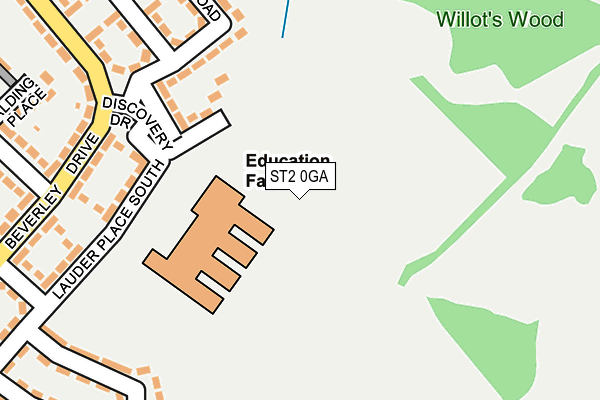
ST2 0GA is located in the Bentilee, Ubberley & Townsend electoral ward, within the unitary authority of Stoke-on-Trent and the English Parliamentary constituency of Stoke-on-Trent Central. The Sub Integrated Care Board (ICB) Location is NHS Staffordshire and Stoke-on-Trent ICB - 05W and the police force is Staffordshire. This postcode has been in use since July 2013.


GetTheData
Source: OS OpenMap – Local (Ordnance Survey)
Source: OS VectorMap District (Ordnance Survey)
Licence: Open Government Licence (requires attribution)
| Easting | 392393 |
| Northing | 345577 |
| Latitude | 53.007450 |
| Longitude | -2.114816 |
GetTheData
Source: Open Postcode Geo
Licence: Open Government Licence
| Country | England |
| Postcode District | ST2 |
➜ See where ST2 is on a map ➜ Where is Stoke-on-Trent? | |
GetTheData
Source: Land Registry Price Paid Data
Licence: Open Government Licence
Elevation or altitude of ST2 0GA as distance above sea level:
| Metres | Feet | |
|---|---|---|
| Elevation | 200m | 656ft |
Elevation is measured from the approximate centre of the postcode, to the nearest point on an OS contour line from OS Terrain 50, which has contour spacing of ten vertical metres.
➜ How high above sea level am I? Find the elevation of your current position using your device's GPS.
GetTheData
Source: Open Postcode Elevation
Licence: Open Government Licence
| Ward | Bentilee, Ubberley & Townsend |
| Constituency | Stoke-on-trent Central |
GetTheData
Source: ONS Postcode Database
Licence: Open Government Licence
| Thornhill Road (Beverley Drive) | Bentilee | 214m |
| Ubberley Road (Beverley Drive) | Bentilee | 232m |
| Thornhill Road (Beverley Drive) | Bentilee | 256m |
| Glenfield Way (Beverley Drive) | Bentilee | 291m |
| Homestead Street (Dawlish Drive) | Bentilee | 411m |
| Longton Station | 2.5km |
| Stoke-on-Trent Station | 4.4km |
| Blythe Bridge Station | 5.4km |
GetTheData
Source: NaPTAN
Licence: Open Government Licence
GetTheData
Source: ONS Postcode Database
Licence: Open Government Licence


➜ Get more ratings from the Food Standards Agency
GetTheData
Source: Food Standards Agency
Licence: FSA terms & conditions
| Last Collection | |||
|---|---|---|---|
| Location | Mon-Fri | Sat | Distance |
| Wendling Close | 17:45 | 09:30 | 931m |
| Newmount Road | 17:30 | 11:15 | 1,936m |
| Ashwood | 18:00 | 10:15 | 2,002m |
GetTheData
Source: Dracos
Licence: Creative Commons Attribution-ShareAlike
The below table lists the International Territorial Level (ITL) codes (formerly Nomenclature of Territorial Units for Statistics (NUTS) codes) and Local Administrative Units (LAU) codes for ST2 0GA:
| ITL 1 Code | Name |
|---|---|
| TLG | West Midlands (England) |
| ITL 2 Code | Name |
| TLG2 | Shropshire and Staffordshire |
| ITL 3 Code | Name |
| TLG23 | Stoke-on-Trent |
| LAU 1 Code | Name |
| E06000021 | Stoke-on-Trent |
GetTheData
Source: ONS Postcode Directory
Licence: Open Government Licence
The below table lists the Census Output Area (OA), Lower Layer Super Output Area (LSOA), and Middle Layer Super Output Area (MSOA) for ST2 0GA:
| Code | Name | |
|---|---|---|
| OA | E00071816 | |
| LSOA | E01014223 | Stoke-on-Trent 017D |
| MSOA | E02002967 | Stoke-on-Trent 017 |
GetTheData
Source: ONS Postcode Directory
Licence: Open Government Licence
| ST2 0QJ | Lauder Place North | 131m |
| ST2 0QF | Beverley Drive | 216m |
| ST2 0QE | Beverley Drive | 230m |
| ST2 0QG | Thornhill Road | 236m |
| ST2 0QU | Glenfield Way | 272m |
| ST2 0QR | Spalding Place | 282m |
| ST2 0QP | Ubberley Road | 289m |
| ST2 0QT | Beverley Drive | 297m |
| ST2 0QS | Ubberley Road | 308m |
| ST2 0RA | Moffat Grove | 318m |
GetTheData
Source: Open Postcode Geo; Land Registry Price Paid Data
Licence: Open Government Licence