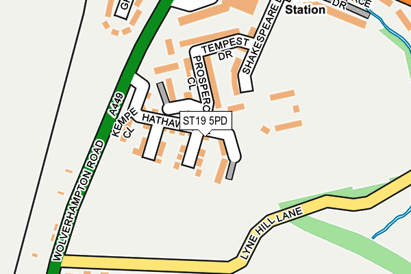
ST19 5PD is located in the Penkridge South & Gailey electoral ward, within the local authority district of South Staffordshire and the English Parliamentary constituency of Stafford. The Sub Integrated Care Board (ICB) Location is NHS Staffordshire and Stoke-on-Trent ICB - 05V and the police force is Staffordshire. This postcode has been in use since October 2016.


GetTheData
Source: OS OpenMap – Local (Ordnance Survey)
Source: OS VectorMap District (Ordnance Survey)
Licence: Open Government Licence (requires attribution)
| Easting | 392072 |
| Northing | 313080 |
| Latitude | 52.715334 |
| Longitude | -2.118793 |
GetTheData
Source: Open Postcode Geo
Licence: Open Government Licence
| Country | England |
| Postcode District | ST19 |
➜ See where ST19 is on a map ➜ Where is Penkridge? | |
GetTheData
Source: Land Registry Price Paid Data
Licence: Open Government Licence
Elevation or altitude of ST19 5PD as distance above sea level:
| Metres | Feet | |
|---|---|---|
| Elevation | 90m | 295ft |
Elevation is measured from the approximate centre of the postcode, to the nearest point on an OS contour line from OS Terrain 50, which has contour spacing of ten vertical metres.
➜ How high above sea level am I? Find the elevation of your current position using your device's GPS.
GetTheData
Source: Open Postcode Elevation
Licence: Open Government Licence
| Ward | Penkridge South & Gailey |
| Constituency | Stafford |
GetTheData
Source: ONS Postcode Database
Licence: Open Government Licence
22, HATHAWAY CLOSE, PENKRIDGE, STAFFORD, ST19 5PD 2024 20 SEP £397,500 |
2023 14 JUL £373,000 |
2022 26 AUG £295,000 |
2021 22 OCT £349,950 |
3, HATHAWAY CLOSE, PENKRIDGE, STAFFORD, ST19 5PD 2021 30 SEP £257,950 |
2021 30 SEP £332,500 |
1, HATHAWAY CLOSE, PENKRIDGE, STAFFORD, ST19 5PD 2021 25 JUN £389,950 |
2021 30 APR £249,950 |
36, HATHAWAY CLOSE, PENKRIDGE, STAFFORD, ST19 5PD 2017 24 FEB £324,950 |
22, HATHAWAY CLOSE, PENKRIDGE, STAFFORD, ST19 5PD 2017 17 FEB £339,950 |
GetTheData
Source: HM Land Registry Price Paid Data
Licence: Contains HM Land Registry data © Crown copyright and database right 2025. This data is licensed under the Open Government Licence v3.0.
| Fire Station (Boscomoor Lane) | Boscomoor | 334m |
| Boscomoor Close (Vale Gardens) | Boscomoor | 349m |
| Fire Station (Boscomoor Lane) | Boscomoor | 352m |
| Bungham Lane (Wolverhampton Road) | Rockhouse Estate | 380m |
| Boscomoor Close (Val Gardens) | Boscomoor | 381m |
| Penkridge Station | 0.9km |
GetTheData
Source: NaPTAN
Licence: Open Government Licence
| Percentage of properties with Next Generation Access | 0.0% |
| Percentage of properties with Superfast Broadband | 0.0% |
| Percentage of properties with Ultrafast Broadband | 0.0% |
| Percentage of properties with Full Fibre Broadband | 0.0% |
Superfast Broadband is between 30Mbps and 300Mbps
Ultrafast Broadband is > 300Mbps
| Median download speed | 17.1Mbps |
| Average download speed | 16.9Mbps |
| Maximum download speed | 20.00Mbps |
| Median upload speed | 1.1Mbps |
| Average upload speed | 1.1Mbps |
| Maximum upload speed | 1.30Mbps |
| Percentage of properties unable to receive 2Mbps | 0.0% |
| Percentage of properties unable to receive 5Mbps | 0.0% |
| Percentage of properties unable to receive 10Mbps | 0.0% |
| Percentage of properties unable to receive 30Mbps | 100.0% |
GetTheData
Source: Ofcom
Licence: Ofcom Terms of Use (requires attribution)
GetTheData
Source: ONS Postcode Database
Licence: Open Government Licence


➜ Get more ratings from the Food Standards Agency
GetTheData
Source: Food Standards Agency
Licence: FSA terms & conditions
| Last Collection | |||
|---|---|---|---|
| Location | Mon-Fri | Sat | Distance |
| Boscomoor Road | 17:00 | 09:30 | 354m |
| Vale Gardens | 17:00 | 09:00 | 695m |
| Walhouse Drive | 17:00 | 09:15 | 801m |
GetTheData
Source: Dracos
Licence: Creative Commons Attribution-ShareAlike
The below table lists the International Territorial Level (ITL) codes (formerly Nomenclature of Territorial Units for Statistics (NUTS) codes) and Local Administrative Units (LAU) codes for ST19 5PD:
| ITL 1 Code | Name |
|---|---|
| TLG | West Midlands (England) |
| ITL 2 Code | Name |
| TLG2 | Shropshire and Staffordshire |
| ITL 3 Code | Name |
| TLG24 | Staffordshire CC |
| LAU 1 Code | Name |
| E07000196 | South Staffordshire |
GetTheData
Source: ONS Postcode Directory
Licence: Open Government Licence
The below table lists the Census Output Area (OA), Lower Layer Super Output Area (LSOA), and Middle Layer Super Output Area (MSOA) for ST19 5PD:
| Code | Name | |
|---|---|---|
| OA | E00151118 | |
| LSOA | E01029658 | South Staffordshire 001D |
| MSOA | E02006174 | South Staffordshire 001 |
GetTheData
Source: ONS Postcode Directory
Licence: Open Government Licence
| ST19 5NS | Wolverhampton Road | 180m |
| ST19 5LU | Grange Crescent | 221m |
| ST19 5NT | Lyne Hill Lane | 233m |
| ST19 5NH | Bungham Lane | 326m |
| ST19 5LP | Boscomoor Close | 359m |
| ST19 5NU | Boscomoor Lane | 372m |
| ST19 5NW | Grange Avenue | 414m |
| ST19 5JZ | Manston Hill | 435m |
| ST19 5LR | Vale Gardens | 437m |
| ST19 5NJ | Grange Road | 453m |
GetTheData
Source: Open Postcode Geo; Land Registry Price Paid Data
Licence: Open Government Licence