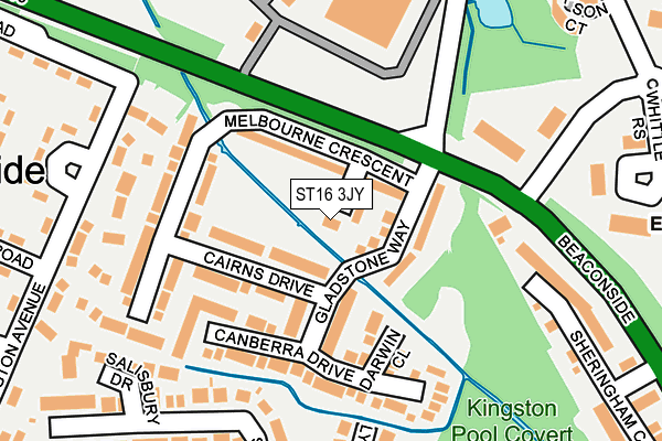
ST16 3JY lies on Tasman Drive in Stafford. ST16 3JY is located in the Littleworth electoral ward, within the local authority district of Stafford and the English Parliamentary constituency of Stafford. The Sub Integrated Care Board (ICB) Location is NHS Staffordshire and Stoke-on-Trent ICB - 05V and the police force is Staffordshire. This postcode has been in use since January 1980.


GetTheData
Source: OS OpenMap – Local (Ordnance Survey)
Source: OS VectorMap District (Ordnance Survey)
Licence: Open Government Licence (requires attribution)
| Easting | 394002 |
| Northing | 324088 |
| Latitude | 52.814300 |
| Longitude | -2.090433 |
GetTheData
Source: Open Postcode Geo
Licence: Open Government Licence
| Street | Tasman Drive |
| Town/City | Stafford |
| Country | England |
| Postcode District | ST16 |
➜ See where ST16 is on a map ➜ Where is Stafford? | |
GetTheData
Source: Land Registry Price Paid Data
Licence: Open Government Licence
Elevation or altitude of ST16 3JY as distance above sea level:
| Metres | Feet | |
|---|---|---|
| Elevation | 80m | 262ft |
Elevation is measured from the approximate centre of the postcode, to the nearest point on an OS contour line from OS Terrain 50, which has contour spacing of ten vertical metres.
➜ How high above sea level am I? Find the elevation of your current position using your device's GPS.
GetTheData
Source: Open Postcode Elevation
Licence: Open Government Licence
| Ward | Littleworth |
| Constituency | Stafford |
GetTheData
Source: ONS Postcode Database
Licence: Open Government Licence
| Portal Road (Ellington Avenue) | Coton Fields | 217m |
| Marconi Gate (Dyson Way) | Beaconside | 222m |
| Portal Road (Ellington Avenue) | Coton Fields | 226m |
| Marconi Gate (Dyson Way) | Beaconside | 235m |
| Salmond Avenue (Portal Road) | Coton Fields | 285m |
| Stafford Station | 2.4km |
GetTheData
Source: NaPTAN
Licence: Open Government Licence
| Percentage of properties with Next Generation Access | 100.0% |
| Percentage of properties with Superfast Broadband | 100.0% |
| Percentage of properties with Ultrafast Broadband | 100.0% |
| Percentage of properties with Full Fibre Broadband | 0.0% |
Superfast Broadband is between 30Mbps and 300Mbps
Ultrafast Broadband is > 300Mbps
| Median download speed | 100.0Mbps |
| Average download speed | 73.2Mbps |
| Maximum download speed | 200.00Mbps |
| Median upload speed | 4.0Mbps |
| Average upload speed | 4.0Mbps |
| Maximum upload speed | 7.01Mbps |
| Percentage of properties unable to receive 2Mbps | 0.0% |
| Percentage of properties unable to receive 5Mbps | 0.0% |
| Percentage of properties unable to receive 10Mbps | 0.0% |
| Percentage of properties unable to receive 30Mbps | 0.0% |
GetTheData
Source: Ofcom
Licence: Ofcom Terms of Use (requires attribution)
Estimated total energy consumption in ST16 3JY by fuel type, 2015.
| Consumption (kWh) | 78,662 |
|---|---|
| Meter count | 14 |
| Mean (kWh/meter) | 5,619 |
| Median (kWh/meter) | 5,004 |
| Consumption (kWh) | 26,322 |
|---|---|
| Meter count | 10 |
| Mean (kWh/meter) | 2,632 |
| Median (kWh/meter) | 2,102 |
GetTheData
Source: Postcode level gas estimates: 2015 (experimental)
Source: Postcode level electricity estimates: 2015 (experimental)
Licence: Open Government Licence
GetTheData
Source: ONS Postcode Database
Licence: Open Government Licence


➜ Get more ratings from the Food Standards Agency
GetTheData
Source: Food Standards Agency
Licence: FSA terms & conditions
| Last Collection | |||
|---|---|---|---|
| Location | Mon-Fri | Sat | Distance |
| Staffordshire Tech Park | 17:15 | 10:00 | 200m |
| Marlborough Avenue | 17:30 | 09:45 | 310m |
| Alliss Close | 17:15 | 09:45 | 455m |
GetTheData
Source: Dracos
Licence: Creative Commons Attribution-ShareAlike
The below table lists the International Territorial Level (ITL) codes (formerly Nomenclature of Territorial Units for Statistics (NUTS) codes) and Local Administrative Units (LAU) codes for ST16 3JY:
| ITL 1 Code | Name |
|---|---|
| TLG | West Midlands (England) |
| ITL 2 Code | Name |
| TLG2 | Shropshire and Staffordshire |
| ITL 3 Code | Name |
| TLG24 | Staffordshire CC |
| LAU 1 Code | Name |
| E07000197 | Stafford |
GetTheData
Source: ONS Postcode Directory
Licence: Open Government Licence
The below table lists the Census Output Area (OA), Lower Layer Super Output Area (LSOA), and Middle Layer Super Output Area (MSOA) for ST16 3JY:
| Code | Name | |
|---|---|---|
| OA | E00151458 | |
| LSOA | E01029724 | Stafford 011D |
| MSOA | E02006198 | Stafford 011 |
GetTheData
Source: ONS Postcode Directory
Licence: Open Government Licence
| ST16 3PW | Cairns Drive | 70m |
| ST16 3JT | Gladstone Way | 74m |
| ST16 3PY | Darwin Close | 113m |
| ST16 3JU | Melbourne Crescent | 127m |
| ST16 3PX | Canberra Drive | 138m |
| ST18 0FZ | Marconi Gate | 172m |
| ST16 3SF | Salisbury Road | 190m |
| ST16 3SQ | Lymington Road | 230m |
| ST16 3SS | Salisbury Drive | 233m |
| ST16 3SE | Salisbury Road | 242m |
GetTheData
Source: Open Postcode Geo; Land Registry Price Paid Data
Licence: Open Government Licence