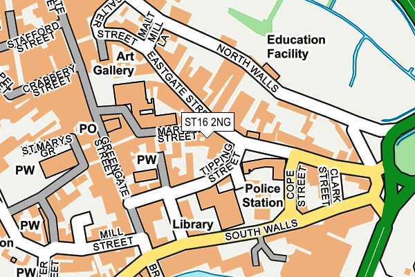
ST16 2NG is located in the Forebridge electoral ward, within the local authority district of Stafford and the English Parliamentary constituency of Stafford. The Sub Integrated Care Board (ICB) Location is NHS Staffordshire and Stoke-on-Trent ICB - 05V and the police force is Staffordshire. This postcode has been in use since January 1980.


GetTheData
Source: OS OpenMap – Local (Ordnance Survey)
Source: OS VectorMap District (Ordnance Survey)
Licence: Open Government Licence (requires attribution)
| Easting | 392347 |
| Northing | 323238 |
| Latitude | 52.806637 |
| Longitude | -2.114967 |
GetTheData
Source: Open Postcode Geo
Licence: Open Government Licence
| Country | England |
| Postcode District | ST16 |
➜ See where ST16 is on a map ➜ Where is Stafford? | |
GetTheData
Source: Land Registry Price Paid Data
Licence: Open Government Licence
Elevation or altitude of ST16 2NG as distance above sea level:
| Metres | Feet | |
|---|---|---|
| Elevation | 80m | 262ft |
Elevation is measured from the approximate centre of the postcode, to the nearest point on an OS contour line from OS Terrain 50, which has contour spacing of ten vertical metres.
➜ How high above sea level am I? Find the elevation of your current position using your device's GPS.
GetTheData
Source: Open Postcode Elevation
Licence: Open Government Licence
| Ward | Forebridge |
| Constituency | Stafford |
GetTheData
Source: ONS Postcode Database
Licence: Open Government Licence
| Shrewsbury Arms Ph (Eastgate St) | Stafford Town Centre | 23m |
| Police Station (Pitcher Bank) | Stafford Town Centre | 99m |
| Police Station (Cope Street) | Stafford Town Centre | 123m |
| Gatehouse Theatre (Eastgate St) | Stafford Town Centre | 123m |
| Cope Street (South Walls) | Stafford Town Centre | 151m |
| Stafford Station | 0.6km |
GetTheData
Source: NaPTAN
Licence: Open Government Licence
GetTheData
Source: ONS Postcode Database
Licence: Open Government Licence


➜ Get more ratings from the Food Standards Agency
GetTheData
Source: Food Standards Agency
Licence: FSA terms & conditions
| Last Collection | |||
|---|---|---|---|
| Location | Mon-Fri | Sat | Distance |
| Stafford Post Office | 18:30 | 12:00 | 179m |
| Stafford Post Office | 18:30 | 12:00 | 181m |
| Market Square | 184m | ||
GetTheData
Source: Dracos
Licence: Creative Commons Attribution-ShareAlike
The below table lists the International Territorial Level (ITL) codes (formerly Nomenclature of Territorial Units for Statistics (NUTS) codes) and Local Administrative Units (LAU) codes for ST16 2NG:
| ITL 1 Code | Name |
|---|---|
| TLG | West Midlands (England) |
| ITL 2 Code | Name |
| TLG2 | Shropshire and Staffordshire |
| ITL 3 Code | Name |
| TLG24 | Staffordshire CC |
| LAU 1 Code | Name |
| E07000197 | Stafford |
GetTheData
Source: ONS Postcode Directory
Licence: Open Government Licence
The below table lists the Census Output Area (OA), Lower Layer Super Output Area (LSOA), and Middle Layer Super Output Area (MSOA) for ST16 2NG:
| Code | Name | |
|---|---|---|
| OA | E00166308 | |
| LSOA | E01029701 | Stafford 010E |
| MSOA | E02006197 | Stafford 010 |
GetTheData
Source: ONS Postcode Directory
Licence: Open Government Licence
| ST16 2LN | Tipping Street | 67m |
| ST16 2ND | Avarne Place | 81m |
| ST16 2LZ | Eastgate Street | 115m |
| ST16 2JZ | Market Street | 141m |
| ST16 3AD | North Walls | 144m |
| ST16 2HS | Greengate Street | 158m |
| ST16 2JL | Market Square | 163m |
| ST16 2JU | Salter Street | 163m |
| ST16 2JE | Greengate Street | 175m |
| ST16 3AA | South Walls | 175m |
GetTheData
Source: Open Postcode Geo; Land Registry Price Paid Data
Licence: Open Government Licence