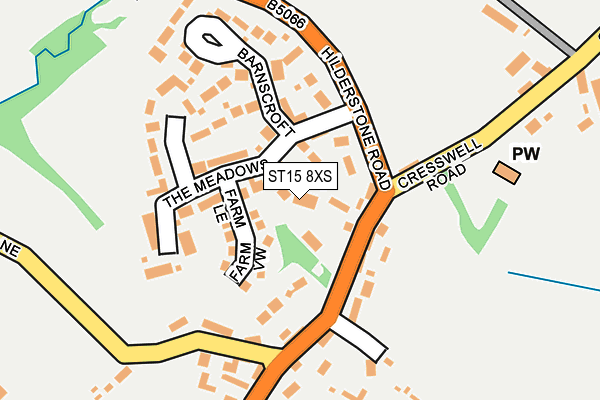
ST15 8XS lies on Bourne Court in Hilderstone, Stone. ST15 8XS is located in the Milwich electoral ward, within the local authority district of Stafford and the English Parliamentary constituency of Stone. The Sub Integrated Care Board (ICB) Location is NHS Staffordshire and Stoke-on-Trent ICB - 05V and the police force is Staffordshire. This postcode has been in use since September 1991.


GetTheData
Source: OS OpenMap – Local (Ordnance Survey)
Source: OS VectorMap District (Ordnance Survey)
Licence: Open Government Licence (requires attribution)
| Easting | 394818 |
| Northing | 334712 |
| Latitude | 52.909811 |
| Longitude | -2.078499 |
GetTheData
Source: Open Postcode Geo
Licence: Open Government Licence
| Street | Bourne Court |
| Locality | Hilderstone |
| Town/City | Stone |
| Country | England |
| Postcode District | ST15 |
➜ See where ST15 is on a map ➜ Where is Hilderstone? | |
GetTheData
Source: Land Registry Price Paid Data
Licence: Open Government Licence
Elevation or altitude of ST15 8XS as distance above sea level:
| Metres | Feet | |
|---|---|---|
| Elevation | 170m | 558ft |
Elevation is measured from the approximate centre of the postcode, to the nearest point on an OS contour line from OS Terrain 50, which has contour spacing of ten vertical metres.
➜ How high above sea level am I? Find the elevation of your current position using your device's GPS.
GetTheData
Source: Open Postcode Elevation
Licence: Open Government Licence
| Ward | Milwich |
| Constituency | Stone |
GetTheData
Source: ONS Postcode Database
Licence: Open Government Licence
2021 1 SEP £515,000 |
2017 6 OCT £395,000 |
2011 28 JAN £350,000 |
GetTheData
Source: HM Land Registry Price Paid Data
Licence: Contains HM Land Registry data © Crown copyright and database right 2025. This data is licensed under the Open Government Licence v3.0.
| Old School (Cresswell Rd) | Hilderstone | 139m |
| Old School (Cresswell Rd) | Hilderstone | 146m |
| The Old Chapel (Sandon Road) | Hilderstone | 510m |
| The Old Chapel (Sandon Rd) | Hilderstone | 544m |
| Bird In Hand Ph (Cresswell Rd) | Sharpley Heath | 1,676m |
GetTheData
Source: NaPTAN
Licence: Open Government Licence
| Percentage of properties with Next Generation Access | 100.0% |
| Percentage of properties with Superfast Broadband | 100.0% |
| Percentage of properties with Ultrafast Broadband | 0.0% |
| Percentage of properties with Full Fibre Broadband | 0.0% |
Superfast Broadband is between 30Mbps and 300Mbps
Ultrafast Broadband is > 300Mbps
| Percentage of properties unable to receive 2Mbps | 0.0% |
| Percentage of properties unable to receive 5Mbps | 0.0% |
| Percentage of properties unable to receive 10Mbps | 0.0% |
| Percentage of properties unable to receive 30Mbps | 0.0% |
GetTheData
Source: Ofcom
Licence: Ofcom Terms of Use (requires attribution)
GetTheData
Source: ONS Postcode Database
Licence: Open Government Licence

➜ Get more ratings from the Food Standards Agency
GetTheData
Source: Food Standards Agency
Licence: FSA terms & conditions
| Last Collection | |||
|---|---|---|---|
| Location | Mon-Fri | Sat | Distance |
| Dingle Lane | 16:00 | 08:00 | 171m |
| Moss Lane | 16:00 | 07:00 | 2,331m |
| Fulford Old Post Office | 16:30 | 10:45 | 2,924m |
GetTheData
Source: Dracos
Licence: Creative Commons Attribution-ShareAlike
The below table lists the International Territorial Level (ITL) codes (formerly Nomenclature of Territorial Units for Statistics (NUTS) codes) and Local Administrative Units (LAU) codes for ST15 8XS:
| ITL 1 Code | Name |
|---|---|
| TLG | West Midlands (England) |
| ITL 2 Code | Name |
| TLG2 | Shropshire and Staffordshire |
| ITL 3 Code | Name |
| TLG24 | Staffordshire CC |
| LAU 1 Code | Name |
| E07000197 | Stafford |
GetTheData
Source: ONS Postcode Directory
Licence: Open Government Licence
The below table lists the Census Output Area (OA), Lower Layer Super Output Area (LSOA), and Middle Layer Super Output Area (MSOA) for ST15 8XS:
| Code | Name | |
|---|---|---|
| OA | E00151501 | |
| LSOA | E01029733 | Stafford 004A |
| MSOA | E02006191 | Stafford 004 |
GetTheData
Source: ONS Postcode Directory
Licence: Open Government Licence
| ST15 8XR | Church Down | 44m |
| ST15 8YF | Farm Lea | 47m |
| ST15 8XT | The Meadows | 78m |
| ST15 8XU | Barnes Croft | 139m |
| ST15 8WD | Roebuck Court | 152m |
| ST15 8XL | Brempton Croft | 167m |
| ST15 8SG | Dingle Lane | 187m |
| ST15 8SF | Sandon Road | 190m |
| ST15 8SE | East Holme | 534m |
| ST15 8SQ | 577m |
GetTheData
Source: Open Postcode Geo; Land Registry Price Paid Data
Licence: Open Government Licence