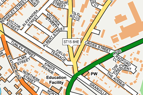
ST15 8HE lies on Old Road in Stone. ST15 8HE is located in the St Michael's & Stonefield electoral ward, within the local authority district of Stafford and the English Parliamentary constituency of Stone. The Sub Integrated Care Board (ICB) Location is NHS Staffordshire and Stoke-on-Trent ICB - 05V and the police force is Staffordshire. This postcode has been in use since January 1980.


GetTheData
Source: OS OpenMap – Local (Ordnance Survey)
Source: OS VectorMap District (Ordnance Survey)
Licence: Open Government Licence (requires attribution)
| Easting | 390130 |
| Northing | 334367 |
| Latitude | 52.906643 |
| Longitude | -2.148196 |
GetTheData
Source: Open Postcode Geo
Licence: Open Government Licence
| Street | Old Road |
| Town/City | Stone |
| Country | England |
| Postcode District | ST15 |
➜ See where ST15 is on a map ➜ Where is Stone? | |
GetTheData
Source: Land Registry Price Paid Data
Licence: Open Government Licence
Elevation or altitude of ST15 8HE as distance above sea level:
| Metres | Feet | |
|---|---|---|
| Elevation | 100m | 328ft |
Elevation is measured from the approximate centre of the postcode, to the nearest point on an OS contour line from OS Terrain 50, which has contour spacing of ten vertical metres.
➜ How high above sea level am I? Find the elevation of your current position using your device's GPS.
GetTheData
Source: Open Postcode Elevation
Licence: Open Government Licence
| Ward | St Michael's & Stonefield |
| Constituency | Stone |
GetTheData
Source: ONS Postcode Database
Licence: Open Government Licence
| Albert Street (Field Terrace) | Stone | 68m |
| Albert Street (Field Terrace) | Stone | 76m |
| Lotus Court (Oulton Road) | Oultoncross | 176m |
| Lotus Court (Oulton Road) | Oultoncross | 232m |
| Alma Street (Station Road) | Stone | 261m |
| Stone Station | 0.5km |
| Barlaston Station | 4.2km |
| Wedgwood Station | 5.2km |
GetTheData
Source: NaPTAN
Licence: Open Government Licence
GetTheData
Source: ONS Postcode Database
Licence: Open Government Licence


➜ Get more ratings from the Food Standards Agency
GetTheData
Source: Food Standards Agency
Licence: FSA terms & conditions
| Last Collection | |||
|---|---|---|---|
| Location | Mon-Fri | Sat | Distance |
| Kings Avenue | 17:30 | 10:30 | 117m |
| Station Road | 17:45 | 10:15 | 290m |
| Newcastle Road | 17:45 | 09:15 | 531m |
GetTheData
Source: Dracos
Licence: Creative Commons Attribution-ShareAlike
The below table lists the International Territorial Level (ITL) codes (formerly Nomenclature of Territorial Units for Statistics (NUTS) codes) and Local Administrative Units (LAU) codes for ST15 8HE:
| ITL 1 Code | Name |
|---|---|
| TLG | West Midlands (England) |
| ITL 2 Code | Name |
| TLG2 | Shropshire and Staffordshire |
| ITL 3 Code | Name |
| TLG24 | Staffordshire CC |
| LAU 1 Code | Name |
| E07000197 | Stafford |
GetTheData
Source: ONS Postcode Directory
Licence: Open Government Licence
The below table lists the Census Output Area (OA), Lower Layer Super Output Area (LSOA), and Middle Layer Super Output Area (MSOA) for ST15 8HE:
| Code | Name | |
|---|---|---|
| OA | E00151570 | |
| LSOA | E01029744 | Stafford 003B |
| MSOA | E02006190 | Stafford 003 |
GetTheData
Source: ONS Postcode Directory
Licence: Open Government Licence
| ST15 8JH | Old Road | 21m |
| ST15 8DZ | Oulton Road | 35m |
| ST15 8EB | Oulton Road | 46m |
| ST15 8HG | Field Terrace | 85m |
| ST15 8HQ | Albert Street | 100m |
| ST15 8DH | Cross Street | 110m |
| ST15 8HD | Kings Avenue | 128m |
| ST15 8HR | Old Road | 128m |
| ST15 8EG | Kings Avenue | 135m |
| ST15 8HN | Edward Street | 139m |
GetTheData
Source: Open Postcode Geo; Land Registry Price Paid Data
Licence: Open Government Licence