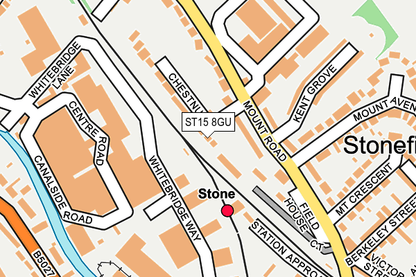
ST15 8GU lies on Chestnut Court in Stone. ST15 8GU is located in the St Michael's & Stonefield electoral ward, within the local authority district of Stafford and the English Parliamentary constituency of Stone. The Sub Integrated Care Board (ICB) Location is NHS Staffordshire and Stoke-on-Trent ICB - 05V and the police force is Staffordshire. This postcode has been in use since December 1998.


GetTheData
Source: OS OpenMap – Local (Ordnance Survey)
Source: OS VectorMap District (Ordnance Survey)
Licence: Open Government Licence (requires attribution)
| Easting | 389637 |
| Northing | 334648 |
| Latitude | 52.909176 |
| Longitude | -2.155533 |
GetTheData
Source: Open Postcode Geo
Licence: Open Government Licence
| Street | Chestnut Court |
| Town/City | Stone |
| Country | England |
| Postcode District | ST15 |
➜ See where ST15 is on a map ➜ Where is Stone? | |
GetTheData
Source: Land Registry Price Paid Data
Licence: Open Government Licence
Elevation or altitude of ST15 8GU as distance above sea level:
| Metres | Feet | |
|---|---|---|
| Elevation | 100m | 328ft |
Elevation is measured from the approximate centre of the postcode, to the nearest point on an OS contour line from OS Terrain 50, which has contour spacing of ten vertical metres.
➜ How high above sea level am I? Find the elevation of your current position using your device's GPS.
GetTheData
Source: Open Postcode Elevation
Licence: Open Government Licence
| Ward | St Michael's & Stonefield |
| Constituency | Stone |
GetTheData
Source: ONS Postcode Database
Licence: Open Government Licence
| Mount Road (Mount Avenue) | Stonefield | 205m |
| Trent Road (Newcastle Road) | Stone | 336m |
| Filleybrooks Garage (Newcastle Road) | Whitebridge Estate | 386m |
| Alma Street (Station Road) | Stone | 393m |
| Filleybrooks Garage (Newcastle Road) | Whitebridge Estate | 404m |
| Stone Station | 0.1km |
| Barlaston Station | 3.8km |
| Wedgwood Station | 4.8km |
GetTheData
Source: NaPTAN
Licence: Open Government Licence
| Percentage of properties with Next Generation Access | 100.0% |
| Percentage of properties with Superfast Broadband | 100.0% |
| Percentage of properties with Ultrafast Broadband | 100.0% |
| Percentage of properties with Full Fibre Broadband | 0.0% |
Superfast Broadband is between 30Mbps and 300Mbps
Ultrafast Broadband is > 300Mbps
| Percentage of properties unable to receive 2Mbps | 0.0% |
| Percentage of properties unable to receive 5Mbps | 0.0% |
| Percentage of properties unable to receive 10Mbps | 0.0% |
| Percentage of properties unable to receive 30Mbps | 0.0% |
GetTheData
Source: Ofcom
Licence: Ofcom Terms of Use (requires attribution)
GetTheData
Source: ONS Postcode Database
Licence: Open Government Licence


➜ Get more ratings from the Food Standards Agency
GetTheData
Source: Food Standards Agency
Licence: FSA terms & conditions
| Last Collection | |||
|---|---|---|---|
| Location | Mon-Fri | Sat | Distance |
| Station Road | 17:45 | 10:15 | 325m |
| Newcastle Road | 17:45 | 09:15 | 416m |
| Kings Avenue | 17:30 | 10:30 | 616m |
GetTheData
Source: Dracos
Licence: Creative Commons Attribution-ShareAlike
The below table lists the International Territorial Level (ITL) codes (formerly Nomenclature of Territorial Units for Statistics (NUTS) codes) and Local Administrative Units (LAU) codes for ST15 8GU:
| ITL 1 Code | Name |
|---|---|
| TLG | West Midlands (England) |
| ITL 2 Code | Name |
| TLG2 | Shropshire and Staffordshire |
| ITL 3 Code | Name |
| TLG24 | Staffordshire CC |
| LAU 1 Code | Name |
| E07000197 | Stafford |
GetTheData
Source: ONS Postcode Directory
Licence: Open Government Licence
The below table lists the Census Output Area (OA), Lower Layer Super Output Area (LSOA), and Middle Layer Super Output Area (MSOA) for ST15 8GU:
| Code | Name | |
|---|---|---|
| OA | E00166320 | |
| LSOA | E01029744 | Stafford 003B |
| MSOA | E02006190 | Stafford 003 |
GetTheData
Source: ONS Postcode Directory
Licence: Open Government Licence
| ST15 8LH | Mount Road | 84m |
| ST15 8GP | Chestnut Grove | 92m |
| ST15 8DD | Mount Road | 93m |
| ST15 8LJ | Mount Road | 120m |
| ST15 8JS | Whitebridge Way | 125m |
| ST15 8YL | Fieldhouse Court | 151m |
| ST15 8LP | Mount Road | 163m |
| ST15 8LQ | Whitebridge Lane | 175m |
| ST15 8LW | Mount Avenue | 184m |
| ST15 8LN | Kent Grove | 191m |
GetTheData
Source: Open Postcode Geo; Land Registry Price Paid Data
Licence: Open Government Licence