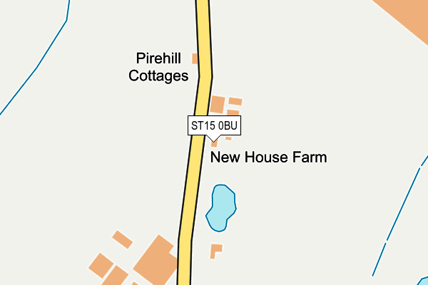
ST15 0BU lies on Pirehill Lane in Stone. ST15 0BU is located in the Milwich electoral ward, within the local authority district of Stafford and the English Parliamentary constituency of Stone. The Sub Integrated Care Board (ICB) Location is NHS Staffordshire and Stoke-on-Trent ICB - 05V and the police force is Staffordshire. This postcode has been in use since January 1980.


GetTheData
Source: OS OpenMap – Local (Ordnance Survey)
Source: OS VectorMap District (Ordnance Survey)
Licence: Open Government Licence (requires attribution)
| Easting | 389836 |
| Northing | 331652 |
| Latitude | 52.882232 |
| Longitude | -2.152481 |
GetTheData
Source: Open Postcode Geo
Licence: Open Government Licence
| Street | Pirehill Lane |
| Town/City | Stone |
| Country | England |
| Postcode District | ST15 |
➜ See where ST15 is on a map | |
GetTheData
Source: Land Registry Price Paid Data
Licence: Open Government Licence
Elevation or altitude of ST15 0BU as distance above sea level:
| Metres | Feet | |
|---|---|---|
| Elevation | 120m | 394ft |
Elevation is measured from the approximate centre of the postcode, to the nearest point on an OS contour line from OS Terrain 50, which has contour spacing of ten vertical metres.
➜ How high above sea level am I? Find the elevation of your current position using your device's GPS.
GetTheData
Source: Open Postcode Elevation
Licence: Open Government Licence
| Ward | Milwich |
| Constituency | Stone |
GetTheData
Source: ONS Postcode Database
Licence: Open Government Licence
| Cuisine De France (Opal Way) | Walton | 500m |
| Cuisine De France (Opal Way) | Walton | 554m |
| Dutton Way (Redfern Rd) | Walton | 659m |
| Capula (Beacon Road) | Walton | 662m |
| Capula (Beacon Road) | Walton | 674m |
| Stone Station | 2.9km |
| Norton Bridge Station | 3.1km |
GetTheData
Source: NaPTAN
Licence: Open Government Licence
| Percentage of properties with Next Generation Access | 100.0% |
| Percentage of properties with Superfast Broadband | 0.0% |
| Percentage of properties with Ultrafast Broadband | 0.0% |
| Percentage of properties with Full Fibre Broadband | 0.0% |
Superfast Broadband is between 30Mbps and 300Mbps
Ultrafast Broadband is > 300Mbps
| Median download speed | 4.1Mbps |
| Average download speed | 4.5Mbps |
| Maximum download speed | 6.60Mbps |
| Median upload speed | 0.8Mbps |
| Average upload speed | 0.8Mbps |
| Maximum upload speed | 1.05Mbps |
| Percentage of properties unable to receive 2Mbps | 100.0% |
| Percentage of properties unable to receive 5Mbps | 100.0% |
| Percentage of properties unable to receive 10Mbps | 100.0% |
| Percentage of properties unable to receive 30Mbps | 100.0% |
GetTheData
Source: Ofcom
Licence: Ofcom Terms of Use (requires attribution)
Estimated total energy consumption in ST15 0BU by fuel type, 2015.
| Consumption (kWh) | 46,318 |
|---|---|
| Meter count | 6 |
| Mean (kWh/meter) | 7,720 |
| Median (kWh/meter) | 8,586 |
GetTheData
Source: Postcode level gas estimates: 2015 (experimental)
Source: Postcode level electricity estimates: 2015 (experimental)
Licence: Open Government Licence
GetTheData
Source: ONS Postcode Database
Licence: Open Government Licence


➜ Get more ratings from the Food Standards Agency
GetTheData
Source: Food Standards Agency
Licence: FSA terms & conditions
| Last Collection | |||
|---|---|---|---|
| Location | Mon-Fri | Sat | Distance |
| Valley Road | 17:45 | 09:30 | 1,184m |
| Aston Village Hall | 17:45 | 07:00 | 1,340m |
| Eccleshall Road | 17:30 | 09:45 | 1,432m |
GetTheData
Source: Dracos
Licence: Creative Commons Attribution-ShareAlike
The below table lists the International Territorial Level (ITL) codes (formerly Nomenclature of Territorial Units for Statistics (NUTS) codes) and Local Administrative Units (LAU) codes for ST15 0BU:
| ITL 1 Code | Name |
|---|---|
| TLG | West Midlands (England) |
| ITL 2 Code | Name |
| TLG2 | Shropshire and Staffordshire |
| ITL 3 Code | Name |
| TLG24 | Staffordshire CC |
| LAU 1 Code | Name |
| E07000197 | Stafford |
GetTheData
Source: ONS Postcode Directory
Licence: Open Government Licence
The below table lists the Census Output Area (OA), Lower Layer Super Output Area (LSOA), and Middle Layer Super Output Area (MSOA) for ST15 0BU:
| Code | Name | |
|---|---|---|
| OA | E00151504 | |
| LSOA | E01029733 | Stafford 004A |
| MSOA | E02006191 | Stafford 004 |
GetTheData
Source: ONS Postcode Directory
Licence: Open Government Licence
| ST15 0BA | Boundary Close | 505m |
| ST15 0AY | Coombe Park Road | 531m |
| ST15 0AZ | Cherry Tree Close | 572m |
| ST15 0LE | Dutton Way | 603m |
| ST15 0LD | Windsor Close | 604m |
| ST15 0AU | Pirehill Lane | 624m |
| ST15 0AX | Hawthorn Avenue | 635m |
| ST15 0LF | Redfern Road | 661m |
| ST15 0LB | Essex Drive | 690m |
| ST15 0LH | Goodill Close | 701m |
GetTheData
Source: Open Postcode Geo; Land Registry Price Paid Data
Licence: Open Government Licence