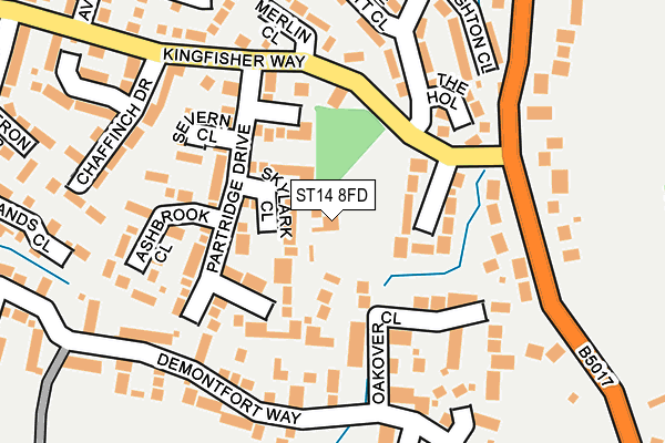
ST14 8FD lies on Woodleighton Road in Uttoxeter. ST14 8FD is located in the Town electoral ward, within the local authority district of East Staffordshire and the English Parliamentary constituency of Burton. The Sub Integrated Care Board (ICB) Location is NHS Staffordshire and Stoke-on-Trent ICB - 05D and the police force is Staffordshire. This postcode has been in use since July 2013.


GetTheData
Source: OS OpenMap – Local (Ordnance Survey)
Source: OS VectorMap District (Ordnance Survey)
Licence: Open Government Licence (requires attribution)
| Easting | 409311 |
| Northing | 332619 |
| Latitude | 52.890944 |
| Longitude | -1.863055 |
GetTheData
Source: Open Postcode Geo
Licence: Open Government Licence
| Street | Woodleighton Road |
| Town/City | Uttoxeter |
| Country | England |
| Postcode District | ST14 |
➜ See where ST14 is on a map ➜ Where is Uttoxeter? | |
GetTheData
Source: Land Registry Price Paid Data
Licence: Open Government Licence
Elevation or altitude of ST14 8FD as distance above sea level:
| Metres | Feet | |
|---|---|---|
| Elevation | 100m | 328ft |
Elevation is measured from the approximate centre of the postcode, to the nearest point on an OS contour line from OS Terrain 50, which has contour spacing of ten vertical metres.
➜ How high above sea level am I? Find the elevation of your current position using your device's GPS.
GetTheData
Source: Open Postcode Elevation
Licence: Open Government Licence
| Ward | Town |
| Constituency | Burton |
GetTheData
Source: ONS Postcode Database
Licence: Open Government Licence
WOOD LEIGHTON HOUSE, WOODLEIGHTON ROAD, UTTOXETER, ST14 8FD 2013 19 JUN £770,000 |
GetTheData
Source: HM Land Registry Price Paid Data
Licence: Contains HM Land Registry data © Crown copyright and database right 2025. This data is licensed under the Open Government Licence v3.0.
| George Elliott Close (Leighton Road) | Balance Hill | 158m |
| Partridge Drive (Kingfisher Way) | Balance Hill | 168m |
| Chaffinch Drive (Kingfisher Way) | Balance Hill | 193m |
| Woodleighton Road (Highwood Road) | Balance Hill | 194m |
| Woodleighton Road (Highwood Road) | Balance Hill | 207m |
| Uttoxeter Station | 0.8km |
GetTheData
Source: NaPTAN
Licence: Open Government Licence
| Percentage of properties with Next Generation Access | 100.0% |
| Percentage of properties with Superfast Broadband | 100.0% |
| Percentage of properties with Ultrafast Broadband | 0.0% |
| Percentage of properties with Full Fibre Broadband | 0.0% |
Superfast Broadband is between 30Mbps and 300Mbps
Ultrafast Broadband is > 300Mbps
| Percentage of properties unable to receive 2Mbps | 0.0% |
| Percentage of properties unable to receive 5Mbps | 0.0% |
| Percentage of properties unable to receive 10Mbps | 0.0% |
| Percentage of properties unable to receive 30Mbps | 0.0% |
GetTheData
Source: Ofcom
Licence: Ofcom Terms of Use (requires attribution)
GetTheData
Source: ONS Postcode Database
Licence: Open Government Licence


➜ Get more ratings from the Food Standards Agency
GetTheData
Source: Food Standards Agency
Licence: FSA terms & conditions
| Last Collection | |||
|---|---|---|---|
| Location | Mon-Fri | Sat | Distance |
| Uttoxeter Post Office | 18:15 | 12:15 | 821m |
| Copes Way | 17:00 | 07:30 | 2,178m |
| Park Crescent | 16:00 | 08:00 | 2,781m |
GetTheData
Source: Dracos
Licence: Creative Commons Attribution-ShareAlike
The below table lists the International Territorial Level (ITL) codes (formerly Nomenclature of Territorial Units for Statistics (NUTS) codes) and Local Administrative Units (LAU) codes for ST14 8FD:
| ITL 1 Code | Name |
|---|---|
| TLG | West Midlands (England) |
| ITL 2 Code | Name |
| TLG2 | Shropshire and Staffordshire |
| ITL 3 Code | Name |
| TLG24 | Staffordshire CC |
| LAU 1 Code | Name |
| E07000193 | East Staffordshire |
GetTheData
Source: ONS Postcode Directory
Licence: Open Government Licence
The below table lists the Census Output Area (OA), Lower Layer Super Output Area (LSOA), and Middle Layer Super Output Area (MSOA) for ST14 8FD:
| Code | Name | |
|---|---|---|
| OA | E00150094 | |
| LSOA | E01029460 | East Staffordshire 003B |
| MSOA | E02006133 | East Staffordshire 003 |
GetTheData
Source: ONS Postcode Directory
Licence: Open Government Licence
| ST14 8UA | Skylark Close | 41m |
| ST14 8BX | Woodleighton Grove | 70m |
| ST14 8UB | Greenfinch Close | 82m |
| ST14 8TZ | Mallard Close | 85m |
| ST14 8TY | Partridge Drive | 110m |
| ST14 8XZ | Oakover Close | 123m |
| ST14 8BY | The Hollow | 139m |
| ST14 8UJ | Severn Close | 155m |
| ST14 8UL | Ashbrook Close | 182m |
| ST14 8BJ | Highwood Road | 184m |
GetTheData
Source: Open Postcode Geo; Land Registry Price Paid Data
Licence: Open Government Licence