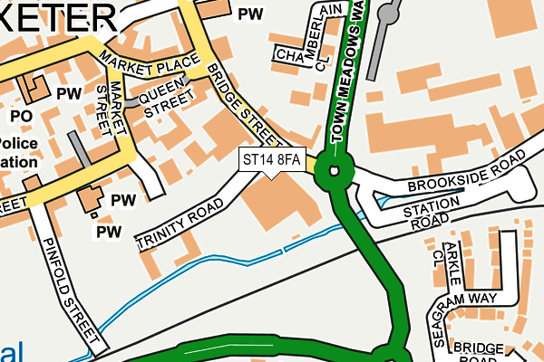
ST14 8FA is located in the Town electoral ward, within the local authority district of East Staffordshire and the English Parliamentary constituency of Burton. The Sub Integrated Care Board (ICB) Location is NHS Staffordshire and Stoke-on-Trent ICB - 05D and the police force is Staffordshire. This postcode has been in use since February 2016.


GetTheData
Source: OS OpenMap – Local (Ordnance Survey)
Source: OS VectorMap District (Ordnance Survey)
Licence: Open Government Licence (requires attribution)
| Easting | 409394 |
| Northing | 333294 |
| Latitude | 52.897010 |
| Longitude | -1.861803 |
GetTheData
Source: Open Postcode Geo
Licence: Open Government Licence
| Country | England |
| Postcode District | ST14 |
➜ See where ST14 is on a map ➜ Where is Uttoxeter? | |
GetTheData
Source: Land Registry Price Paid Data
Licence: Open Government Licence
Elevation or altitude of ST14 8FA as distance above sea level:
| Metres | Feet | |
|---|---|---|
| Elevation | 80m | 262ft |
Elevation is measured from the approximate centre of the postcode, to the nearest point on an OS contour line from OS Terrain 50, which has contour spacing of ten vertical metres.
➜ How high above sea level am I? Find the elevation of your current position using your device's GPS.
GetTheData
Source: Open Postcode Elevation
Licence: Open Government Licence
| Ward | Town |
| Constituency | Burton |
GetTheData
Source: ONS Postcode Database
Licence: Open Government Licence
| Trinity Road (Bridge Street) | Uttoxeter | 53m |
| Railway Station (Station Road) | Uttoxeter | 211m |
| Post Office (Carter Street) | Uttoxeter | 313m |
| Tesco Store (Town Meadows Way) | Uttoxeter Town Centre | 356m |
| Thomas Alleynes High School (Dove Bank (S)) | Uttoxeter Town Centre | 413m |
| Uttoxeter Station | 0.3km |
GetTheData
Source: NaPTAN
Licence: Open Government Licence
GetTheData
Source: ONS Postcode Database
Licence: Open Government Licence


➜ Get more ratings from the Food Standards Agency
GetTheData
Source: Food Standards Agency
Licence: FSA terms & conditions
| Last Collection | |||
|---|---|---|---|
| Location | Mon-Fri | Sat | Distance |
| Uttoxeter Post Office | 18:15 | 12:15 | 319m |
| Copes Way | 17:00 | 07:30 | 1,760m |
| Park Crescent | 16:00 | 08:00 | 2,384m |
GetTheData
Source: Dracos
Licence: Creative Commons Attribution-ShareAlike
The below table lists the International Territorial Level (ITL) codes (formerly Nomenclature of Territorial Units for Statistics (NUTS) codes) and Local Administrative Units (LAU) codes for ST14 8FA:
| ITL 1 Code | Name |
|---|---|
| TLG | West Midlands (England) |
| ITL 2 Code | Name |
| TLG2 | Shropshire and Staffordshire |
| ITL 3 Code | Name |
| TLG24 | Staffordshire CC |
| LAU 1 Code | Name |
| E07000193 | East Staffordshire |
GetTheData
Source: ONS Postcode Directory
Licence: Open Government Licence
The below table lists the Census Output Area (OA), Lower Layer Super Output Area (LSOA), and Middle Layer Super Output Area (MSOA) for ST14 8FA:
| Code | Name | |
|---|---|---|
| OA | E00150102 | |
| LSOA | E01029460 | East Staffordshire 003B |
| MSOA | E02006133 | East Staffordshire 003 |
GetTheData
Source: ONS Postcode Directory
Licence: Open Government Licence
| ST14 8AP | Bridge Street | 62m |
| ST14 8AR | Bridge Street | 116m |
| ST14 8HJ | Queen Street | 121m |
| ST14 8HN | Market Place | 140m |
| ST14 8ET | Chamberlain Close | 150m |
| ST14 8HT | Spiceal Mews | 165m |
| ST14 8HY | Market Place | 167m |
| ST14 8HP | Market Place | 195m |
| ST14 8XH | Arkle Close | 207m |
| ST14 8HF | Market Place | 230m |
GetTheData
Source: Open Postcode Geo; Land Registry Price Paid Data
Licence: Open Government Licence