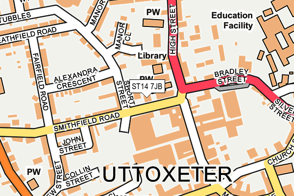
ST14 7JB is located in the Heath electoral ward, within the local authority district of East Staffordshire and the English Parliamentary constituency of Burton. The Sub Integrated Care Board (ICB) Location is NHS Staffordshire and Stoke-on-Trent ICB - 05D and the police force is Staffordshire. This postcode has been in use since January 1980.


GetTheData
Source: OS OpenMap – Local (Ordnance Survey)
Source: OS VectorMap District (Ordnance Survey)
Licence: Open Government Licence (requires attribution)
| Easting | 409050 |
| Northing | 333630 |
| Latitude | 52.900054 |
| Longitude | -1.866904 |
GetTheData
Source: Open Postcode Geo
Licence: Open Government Licence
| Country | England |
| Postcode District | ST14 |
➜ See where ST14 is on a map ➜ Where is Uttoxeter? | |
GetTheData
Source: Land Registry Price Paid Data
Licence: Open Government Licence
Elevation or altitude of ST14 7JB as distance above sea level:
| Metres | Feet | |
|---|---|---|
| Elevation | 90m | 295ft |
Elevation is measured from the approximate centre of the postcode, to the nearest point on an OS contour line from OS Terrain 50, which has contour spacing of ten vertical metres.
➜ How high above sea level am I? Find the elevation of your current position using your device's GPS.
GetTheData
Source: Open Postcode Elevation
Licence: Open Government Licence
| Ward | Heath |
| Constituency | Burton |
GetTheData
Source: ONS Postcode Database
Licence: Open Government Licence
| Wellington Inn (High Street) | Uttoxeter Town Centre | 157m |
| Wellington Inn (High Street) | Uttoxeter Town Centre | 181m |
| Post Office (Carter Street) | Uttoxeter | 214m |
| Smithfield Road (Stone Road) | Uttoxeter | 317m |
| Cheadle Road (High Street) | The Wharf | 349m |
| Uttoxeter Station | 0.7km |
GetTheData
Source: NaPTAN
Licence: Open Government Licence
GetTheData
Source: ONS Postcode Database
Licence: Open Government Licence


➜ Get more ratings from the Food Standards Agency
GetTheData
Source: Food Standards Agency
Licence: FSA terms & conditions
| Last Collection | |||
|---|---|---|---|
| Location | Mon-Fri | Sat | Distance |
| Uttoxeter Post Office | 18:15 | 12:15 | 223m |
| Copes Way | 17:00 | 07:30 | 1,286m |
| Park Crescent | 16:00 | 08:00 | 2,612m |
GetTheData
Source: Dracos
Licence: Creative Commons Attribution-ShareAlike
The below table lists the International Territorial Level (ITL) codes (formerly Nomenclature of Territorial Units for Statistics (NUTS) codes) and Local Administrative Units (LAU) codes for ST14 7JB:
| ITL 1 Code | Name |
|---|---|
| TLG | West Midlands (England) |
| ITL 2 Code | Name |
| TLG2 | Shropshire and Staffordshire |
| ITL 3 Code | Name |
| TLG24 | Staffordshire CC |
| LAU 1 Code | Name |
| E07000193 | East Staffordshire |
GetTheData
Source: ONS Postcode Directory
Licence: Open Government Licence
The below table lists the Census Output Area (OA), Lower Layer Super Output Area (LSOA), and Middle Layer Super Output Area (MSOA) for ST14 7JB:
| Code | Name | |
|---|---|---|
| OA | E00150098 | |
| LSOA | E01029462 | East Staffordshire 003D |
| MSOA | E02006133 | East Staffordshire 003 |
GetTheData
Source: ONS Postcode Directory
Licence: Open Government Licence
| ST14 7LG | Smithfield Road | 37m |
| ST14 7LH | Short Street | 64m |
| ST14 7FN | Carters Square | 88m |
| ST14 7LE | Smithfield Road | 114m |
| ST14 7HN | High Street | 125m |
| ST14 7LQ | Alexandra Crescent | 129m |
| ST14 7JR | The Steeplechase | 130m |
| ST14 7JD | High Street | 133m |
| ST14 7QA | Bradley Street | 139m |
| ST14 7QU | James Street | 141m |
GetTheData
Source: Open Postcode Geo; Land Registry Price Paid Data
Licence: Open Government Licence